Mapping Lyme Disease Risk from Space

Researchers used field and remote sensing data to map the spread of ticks carrying Lyme disease bacteria in central and eastern Canada.
author-share


Image
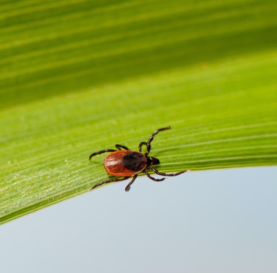
Deer tick (species name Ixodes scapularis) is shown on a green leaf. Deer ticks carry the bacteria that causes Lyme disease.
Deer ticks (Ixodes scapularis), or black-legged ticks, carry the bacteria that causes Lyme disease. Image from Catherine Bouchard, Public Health Agency of Canada.

In the summer of 2014, I spent a day in Rock Creek Park in Washington, D.C. I was hiking off-trail, venturing into the woods, and, most importantly, not wearing bug spray. A few days later I felt tired and achy. I thought I had a bad cold or the flu.

Later, while I was swimming in a pool, my boyfriend pointed at my back with a terrified look on his face. “You have a big bull's-eye rash on your left shoulder blade,” he said. Sure enough, the glaring bull's-eye rash on my back told me I had probably been bitten by a tick carrying bacteria known as Borrelia burgdorferi, which causes Lyme disease.

I had only recently moved to D.C. and hadn't realized that I needed to check for ticks. The doctor confirmed that it was Lyme disease and I took a hefty course of antibiotics to clear it from my system.

Lyme disease is one of the most common vector-borne diseases in North America. In 2014, my case was one of more than 25,350 reported in the U.S., according to the CDC. Deer ticks (Ixodes scapularis), which carry the bacteria that cause Lyme disease, are found in warm, forested areas in the Northern Hemisphere. And as the global climate warms, deer ticks are migrating north, which means more people are at risk of contracting the disease.

Dr. Serge Olivier Kotchi, who works at the Public Health Agency of Canada, studies Lyme disease as a medical geographer, which means he studies health and disease from a geographic perspective. Specifically, Kotchi has been studying how climate change impacts the incidence of vector-borne diseases in Canada, such as Lyme and West Nile Virus.

Kotchi and his colleagues recently published a study in Remote Sensing which found that the risk of Lyme disease in Canada is expanding north as temperatures change. They found that between 2000 and 2015, Lyme risk doubled in the province of Quebec in eastern Canada and tripled in the province of Manitoba in central Canada.
Image
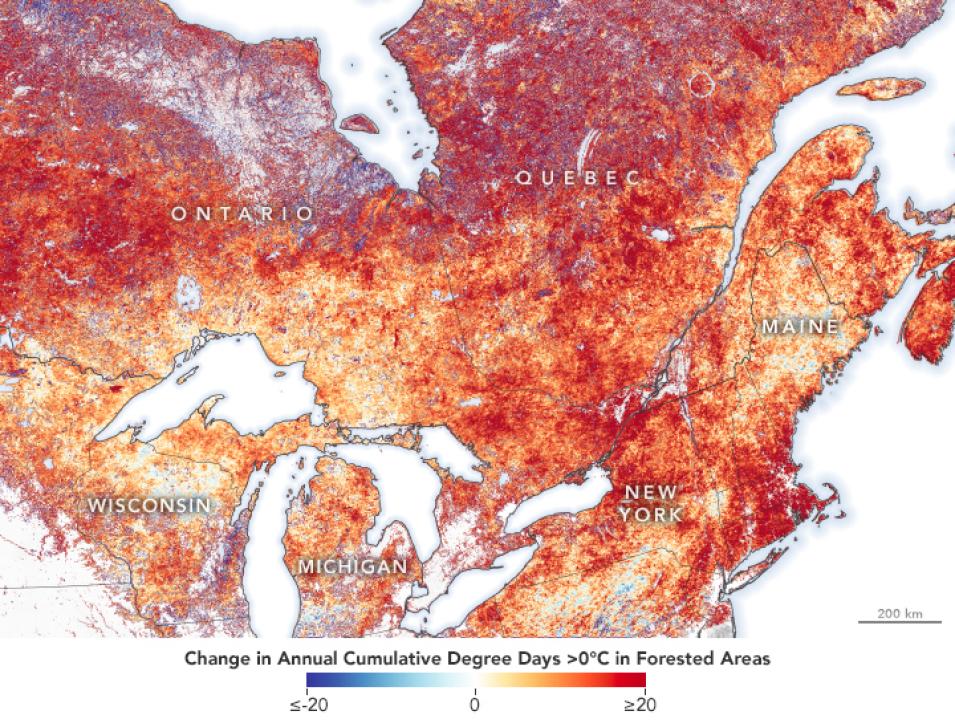
daysabovezero_tmo_2015

The authors mapped established populations of deer ticks by using field data of tick surveillance from previous research in combination with remote sensing data and temperature data from meteorological stations.

Previous field research in Canada used a technique called drag sampling to determine the presence of deer ticks. Researchers drag a square meter piece of cloth through the woods and count the number of ticks that fall on the cloth. This sampling technique also involves capturing rodents in live traps and examining them for ticks and Lyme exposure.


In order to map Lyme risk over a large area at a 1 kilometer resolution, Kotchi and his colleagues combined these field data with remote sensing data from the Moderate Resolution Imaging Spectroradiometer (MODIS) instrument. He used MODIS land surface temperature (MOD11A2) and land cover data (MCD12Q1), which are archived at NASA’s Land Processes Distributed Active Archive Center (LP DAAC).

Deer ticks die off in freezing temperatures, but warmer winters in Canada are allowing ticks to establish farther north. The authors used MODIS temperature data to predict suitable deer tick habitat. They did this by looking at average temperature for each day and summing the degrees the average temperature exceeded 0°C over the whole year (a measurement known as degree days). Using these calculations of degree days in a year, the authors developed an algorithm to predict tick occurrence. They found that much of central and eastern Canada warmed by 15 to 35 degree days per year, making these areas more habitable to deer ticks. Some places in southern Manitoba, Ontario, and Quebec warmed more than 35 degree days per year.

Image
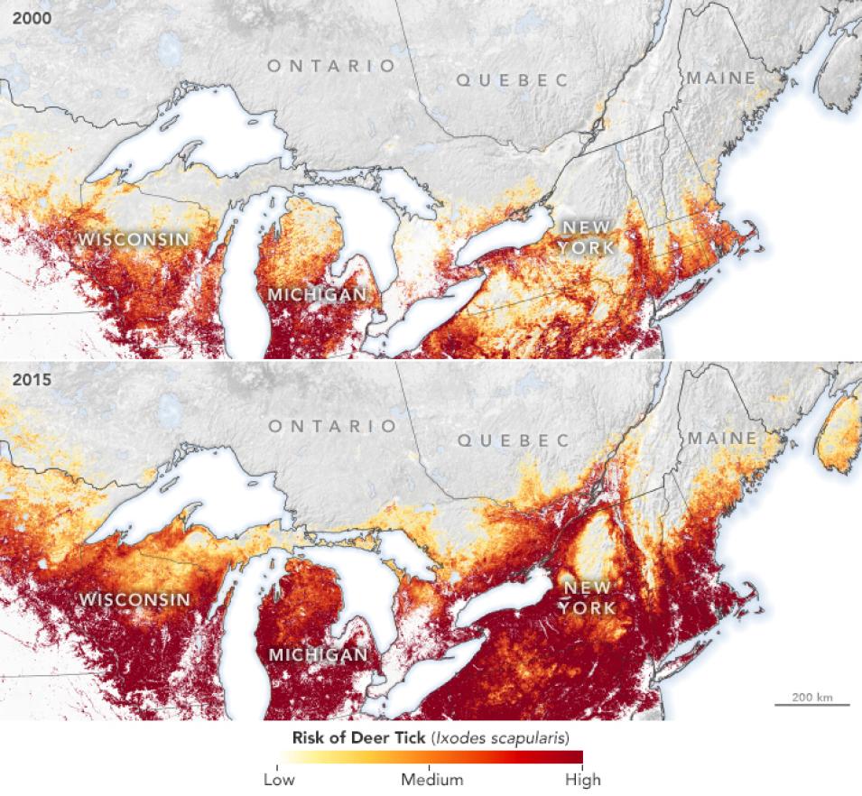
ixodesscapularisrisk_tmo_2015


The authors developed maps of annual Lyme risk in terms of number of adult deer ticks within a square kilometer. The risk maps show that in Quebec province, the average number of deer ticks per square kilometer rose from 56 in the year 2000 to 103 in 2015. In Manitoba province, the number of deer ticks tripled, from 36 per square kilometer to 110.

The risk for Lyme disease is highest in southern parts of Canada, which are also more populated. Kotchi found that during 2012, which was an especially hot year, Lyme disease risk in every Canadian province was higher than all of the other years he analyzed.

As the climate warms, Lyme disease risk in Canada is expected to increase. “The first cases of Lyme disease in Quebec were in the late 1990s,” said Kotchi. “Lyme has been expanding in Canada ever since.” According to the Public Health Agency of Canada, Lyme disease cases in Canada increased from 144 in 2009 to 992 in 2016.

Kotchi’s work is instrumental in helping the Public Health Agency of Canada assess emerging tick populations and communicate Lyme risk to its citizens.

Learn more

Kotchi, S.O., Bouchard, C., Brazeau, S. & Ogden, N.H. (2021). Earth Observation-Informed Risk Maps of the Lyme Disease Vector Ixodes scapularis in Central and Eastern Canada. Remote Sensing, 13(3): 524 [doi:10.3390/rs13030524].

Find NASA data related to environmental variables that can be used to investigate disease transmission and spread, along with resources for using these data in the new Diseases Data Pathfinder.

Last Updated