IMPACTS Campaign Investigates the Processes Causing Snowfall in Winter Storms

IMPACTS—the first campaign to study intense East Coast snowstorms in the past 30 years—aims to give scientists a better understanding of what drives the processes that generate snowfall in the snowbands of intense storms.
author-share
Image
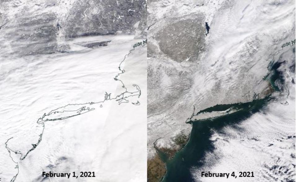
These before-and-after images from the Moderate Resolution Imaging Spectroradiometer (MODIS) aboard NASA’s Terra satellite show area impacted by the winter storm that hit the New York and New Jersey on February 1, 2021, and its aftermath on February 4. For a closer look at these images, visit NASA Worldview.

States of emergency were declared for New Jersey, New York City, and more than 40 counties in New York State on February 1, 2021, after a massive winter storm pummeled the East Coast. The storm’s heavy snows and high winds closed schools, cancelled thousands of flights, and wreaked havoc on local travel—and if there wasn’t a global pandemic, there would have likely been a NASA P-3 Orion research aircraft flying right through its most intense snowbands.

Outfitted with an array of state-of-the-art microphysics probes and dropsonde capabilities, the P-3 aircraft is one of two planes used in NASA’s Investigation of Microphysics and Precipitation for Atlantic Coast-Threatening Snowstorms (IMPACTS) field campaign. The other is the ER-2 and, together, they’ll collect an impressive amount of data that scientists will use to identify and investigate the processes that form and drive the snowbands inside winter storms.

Winter snowstorms like the one that brought New York City and New Jersey to a stand-still last February are not uncommon along the East Coast. Yet the processes inside these storms that produce such large amounts of snow are poorly understood by scientists and poorly predicted by the numerical weather models. IMPACTS, the first comprehensive study of East Coast snowstorms in 30 years, aims to change that.

“The goal of IMPACTS is to give scientists a better understanding of what is driving the processes that create and generate snowfall, particularly the intense snow bands,” said Dr. Geoffrey Stano, Chief Scientist at NASA’s Global Hydrometeorology Resource Center Distributed Active Archive Center (GHRC DAAC). “This will improve our scientific understanding, which in turn could be applied to operational forecasting.”

Funded by NASA’s Earth Venture program, IMPACTS has three main objectives: provide observations critical to understanding the mechanisms of snowband formation, organization, and evolution; examine how the microphysical characteristics and likely growth mechanisms of snow particles vary across snowbands; and improve remotely sensed interpretations and modeling of snowfall to advance prediction capabilities.

That IMPACTS is the first major field campaign to investigate these processes in the past 30 years is significant, as it gives scientists an opportunity to study these storms with the latest remote sensing and meteorological technologies.

“What makes [IMPACTS] interesting is that you have the Geostationary Operational Environmental Satellite-16 (GOES-16) satellite that’s constantly running for you, you have the National Weather Service’s radar, soundings, and weather balloons and, on top of all that normal instrumentation, the field campaign is bringing together different universities that provide different ground instrumentation, such as launching weather balloons at different locations and times, and ground instruments that help identify the type and amount of precipitation, and you put that in the way of the storm versus waiting for the storm to come to you,” said Stano. “At the same time, you have aircraft—the ER-2 and the P-3—providing instrumentation that, in the P-3’s case, allow you to take in-situ measurements from inside clouds. There is really no other way to get these kinds of observations.”

Those aircraft—the ER-2 and the P-3—comprise the heart of the IMPACTS mission, as the instruments they carry provide a range of measurements for the campaign’s study of snow-generation processes.
Image
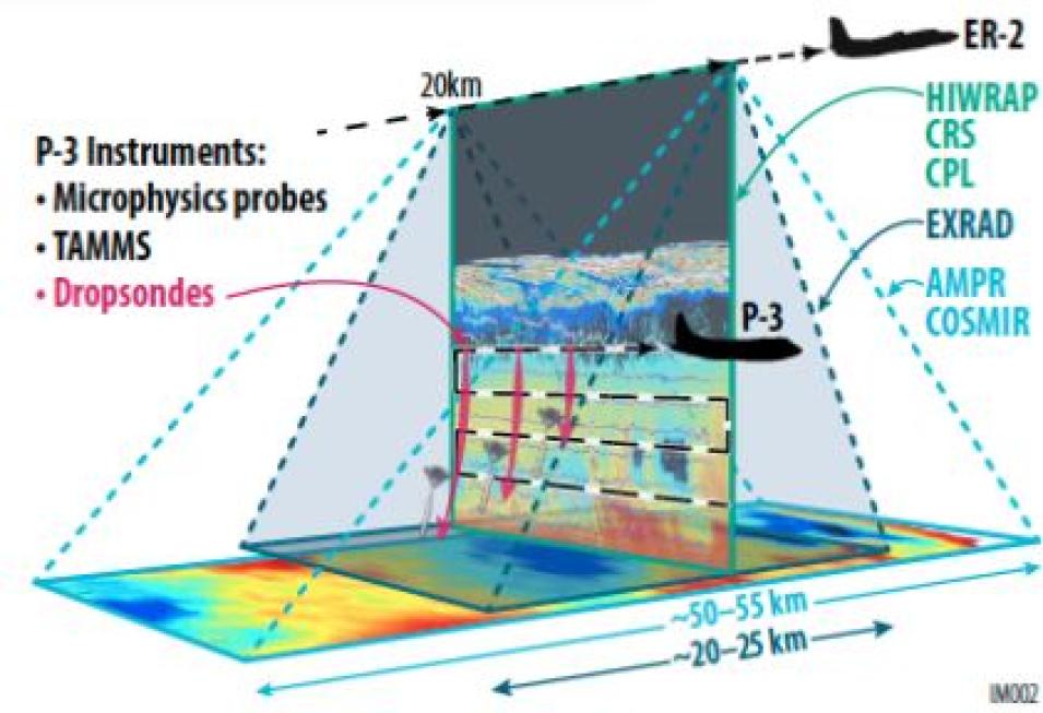
This graphic shows the how the ER-2 and P-3 planes fly in a near-vertical stacked formation during the IMPACTS field campaign. Image credit: IMPACTS.


“We have two aircraft,” said Dr. Lynn McMurdie, Principal Investigator with the IMPACTS field campaign. “One that flies well above the storms, the ER-2, that has remote-sensing instrumentation—radar and lidar and passive microwave instruments, and the P-3 that flies underneath it, in the clouds themselves, with microphysics probes that collect different information about cloud particles.”

The two aircraft fly in a coordinated, near-vertically stacked, pattern, with the ER-2 above the storm and the P-3 inside it.

“All along our plan has been to coordinate those two aircraft so one flies underneath the other and the one on top is informed by the measurements collected by the one underneath,” said McMurdie. “The P-3 will fly at different elevations [inside the storms] because the nature of a cloud changes with its height. It’s different up at the top, than in the middle, and down low. So, we know that we want to fly them together and we know we want to fly them where snowfall is occurring within the storm.”

The P-3 aircraft flies at altitudes ranging from 4,000 to 22,000 feet and its probes physically sample clouds and precipitation. The ER-2 flies much higher, at approximately 65,000 feet, and it carries radars that provide data on the structure of vertical clouds and precipitation structure and intensity, passive microwave radiometers (identical to those aboard NASA satellites) that measure rainfall from space, lidar (vertically pointed laser) that helps identify particle type and density inside storms, and a lightning instrument that can observe the electrical field within storms.

When analyzed in concert with observations from ground sensors and satellite instruments, the data from this suite of airborne instruments can help scientists gain valuable insights into the processes at work within winter storms.

“We get a lot of information from both airplanes, as both are unique ways to examine the structure of storm systems and exactly where you have enhancement of snowfall,” McMurdie said. “We also have radar on the ground but [it doesn’t] give us a lot of vertical structure, and the processes that make the snowfall happen at different levels. The radar on the [ER-2] looks straight down and gives very high-resolution vertical information. At the same time, we are flying inside the clouds, which is something you don’t do in a normal day.”

Like pieces of a puzzle, the amalgam of all these different data sources allows scientists to establish a more comprehensive picture of what is physically occurring inside snowstorms.

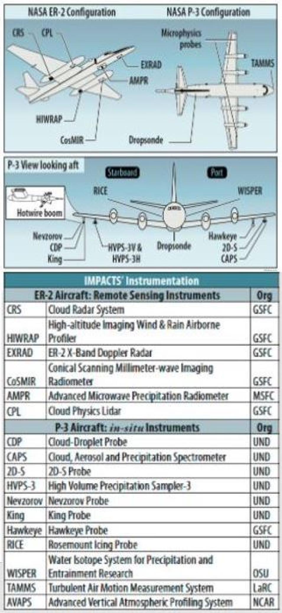
Image
This graphic shows the location of each instrument carried aboard the ER-2 and P-3 aircraft.

“You can bring a lot of related instrumentation together to help develop a physical understanding of what is being observed,” said Stano. “What’s interesting about that is, not only does that help advance the state of the science but, eventually, that knowledge can go into the operational environment.”

In addition, data from the campaign can also serve as a validation technique for instrumentation that’s already been launched.

“Prior to the IMPACTS field campaign, one of the last big field campaigns that our DAAC focused on was the GOES-R post-launch test field campaign,” Stano said. “That campaign, which crossed the entire United States, was specifically set up to test and validate all the earth-observing instruments aboard GOES-16. IMPACTS is kind of looking at things from a slightly different perspective but, obviously, you get the opportunity to compare instrumentation again.”

McMurdie agrees, noting that co-locating instruments gives the IMPACTS team a chance to confirm the accuracy of their measurements.

“The GPM satellite has a radar with the same wavelength as one of the radars on our aircraft, so if we’re lucky and there happens to be a GPM overpass, we’ll line-up right along it and make measurements from the aircraft at the same time the satellite is going overhead,” she said. “You can really test how you deduce how much snowfall is occurring on the ground with what we actually measured. That really informs our algorithms.”

IMPACTS is still in its early stages. The first of its three deployments began January 17, 2020, and ended March 1, 2020, just before the pandemic. Its second deployment was originally scheduled for the winter of 2021, but COVID restrictions kept the planes grounded. Currently, the IMPACTS team plans to conduct its next flights this coming winter (January through February) and then once more during the winter of 2023.

Yet, even though there are still two deployments to come, the datasets from the first IMPACTS flights have already been processed and archived and are currently available from GHRC DAAC. The collection features more than 60 datasets covering 19 parameters, including Radar, Atmospheric Water Vapor, Atmospheric Temperature, Clouds, Precipitation, Aerosols, Lidar, and Atmospheric Electricity, and the data are available in NetCDF, ASCII, and HDF-5 formats. The processing levels of IMPACTS data range from 0 to 3.

Beyond the data, GHRC DAAC has provided users with a variety of data-related resources as well.

“We developed user guides that provide a detailed breakdown of every dataset and say, ‘this is what this file is for,’” Stano said. “We try to make sure that we collate other known information about the instrument [the dataset is from], if any of the instruments have flown previously in other campaigns, and we make sure that there are links out to where you can find previous versions of these data.”

The DAAC also provides tools designed to help users explore and visualize data, such as Panoply, a cross-platform application developed by NASA's Goddard Institute for Space Studies (GISS) that plots geo-gridded and other arrays from NetCDF, HDF, GRIB, and other data formats, and Field Campaign Explorer (FCX), a cloud-based tool that assists users with data discovery and helps them more rapidly collect, visualize, and analyze observations from field campaigns. FCX is currently under development but, according to Stano, it will eventually be an open-source tool that allows users to take advantage of FCX’s capabilities by writing their own algorithms for their unique purposes.

Analysis of IMPACTS data is ongoing too.

“We’re probably still in the research and analysis stage. We’ve got their first year’s-worth of data and the researchers and science team are pouring through the observations and starting to identify what they gathered,” said Stano. “That is going to continue for the next two years. They will look for interesting cases where perceptions of what they expected to see didn’t match what happened. Those are cases they really want to try to identify and start looking into to see what the observations provide.”

Therefore, it will likely be some time before data from the IMPACTS campaign informs any East Coast winter weather forecasts.

“We’re not there yet. That’s what we’re trying to get to,” McMurdie said. “We’re trying to understand the processes—how does it happen—instead of better predicting when it will happen. That is also a goal, we do want to improve prediction, because all of our numerical models require a large set of assumptions to predict how much precipitation is actually falling and where, so we are testing those assumptions with these direct measurements.”

Stano concurs.

“From the standpoint of an operational impact—how will this help the meteorological community— we’re going to have to do the analysis and the reviews of the data,” said Stano. “But the hope would be that as papers are written and results are presented to the community, they’ll start developing new tools and new things to look for that could potentially support improved forecasts.”

Whenever that happens, there’s a good chance those forecasts will benefit the millions of people living along the eastern seaboard, helping them better prepare for the storms destined to come their way next winter, and in the winters thereafter.


Last Updated