No Longer Just an Experiment: 30 Years of the IGS

The International Global Navigation Satellite Systems Service (IGS), a voluntary federation of more than 200 self-funding entities, celebrates three decades of providing high-quality data.
author-share
Image
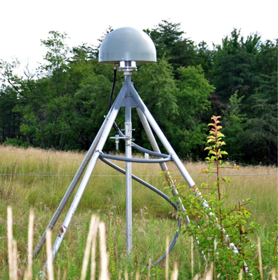
The International GNSS Service (IGS) collects, archives, and distributes Global Navigation Satellite System (GNSS) data from a cooperatively operated global network of ground tracking stations. IGS stations provide continuous tracking using high accuracy receivers (shown above) and have data transmission facilities allowing for rapid data transmission to data centers. Credit: NASA's CDDIS.

Every day, people around the world use the Global Navigation Satellite System (GNSS) to accurately pinpoint their location on Earth. Yet the amount of effort that goes into building, maintaining, and ensuring high-quality GNSS data is often underestimated.

"It's a bit like turning on a light switch or plugging something into an electrical socket," said Allison Craddock. "You don't sit and contemplate how the electricity works, where the power plant is, or what the infrastructure looks like. It's so ubiquitous and so reliable, most users don’t stop to think about how it is made."

Craddock would know. As director of the Central Bureau of the International GNSS Service (IGS), she has a front-row seat to the effort that goes into making GNSS the reliable global service it has become.

The IGS is a voluntary federation of more than 200 self-funding agencies, universities, and research institutions in more than 100 countries and regions that work together to produce high-quality GNSS data, products, and services. The IGS celebrated its 30th anniversary in January 2024, and according to Dr. Rolf Dach, chair of the IGS Governing Board and professor in the Astronomical Institute at the University of Bern in Switzerland, it’s a noteworthy milestone given the nature of the organization.

"I think the spectacular thing about the IGS is that it's a voluntary organization. There is no commercial commitment, but nevertheless people see it as infrastructure, as something that's always there for them," Dach said. "It shows that we’ve established a very reliable service over these 30 years."

Craddock agrees. "The 30th anniversary shows that this is not just an experiment anymore, that it didn't begin and end with just one group of people," she said. "We now see people coming into it from different parts of the world who are interested and want to participate. In that regard, it's passed the test, and it shows that, hopefully, the organization is here to stay."

Founded in 1994, the IGS provides free and open access to high-precision GNSS data products that support a wide variety of applications in virtually all segments of the global economy. These include products that support realization of the International Terrestrial Reference Frame (ITRF), the standard frame that serves as the basis for any position-based information and includes mapping, 3D modeling, and geographic information systems (GIS). The IGS also provides access to tracking data from more than 500 worldwide reference stations, supports geodetic research and scholarly publications, and fosters the continuous development of new applications and products through working groups and pilot projects.

Since its creation more than three decades ago, the applications for GNSS data and its user base have grown exponentially. The IGS has grown right along with them.
Image
This graphic of the IGS network shows the location of GNSS receivers in North America, Central America, a portion of South America, parts of western Europe, and western Africa. See the entire network on the IGS website. Credit: IGS.

"[The IGS] has been progressing with—and often driving—scientific advancements, and this is because at its core is a global community that cares about its work, about the services it provides, and about working together to make sure the science is advancing for everyone’s benefit," said Craddock. "It's remarkable to see how things have grown and grown strategically in a way that is strong and sustainable and collaborative. We now have on our Governing Board representatives from six continents. That's not an accident. We know that diversity in infrastructure as well as participation means everybody benefits."

To fulfill its mission and provide the ever-growing community of GNSS users with the free and open data they need, the IGS relies on 6 global, 7 regional, and 16 operational data centers responsible for performing tasks such as collecting data from GNSS tracking stations and processing, validating, and archiving data with a minimum of delay or downtime.

One of the six global data centers is NASA's Crustal Dynamics Data Information System (CDDIS), which, in Dach's words, has been the "central point of GNSS data collection from the beginning" and holds "one of the most complete sets of observation files and products."

CDDIS is NASA's official archive for space geodesy data and one of the NASA Earth Observing System Data and Information System's (EOSDIS) 12 Distributed Active Archive Centers (DAACs). As an IGS central facility, CDDIS not only provides users with access to data generated by the IGS network, it also serves the IGS by providing its members with the data they need to improve existing data products and create new ones.

"We receive tracking data from all over the globe, which are collected and archived by data centers like CDDIS. From there, the IGS's Analysis Centers collect these measurements and generate new products from them. Then the products are sent back to the data centers and an Analysis Center Coordinator compares and contrasts each product's approach and solutions,"said Dach. "What's important is that you have an open exchange of ideas. We refer to this as 'friendly competition' or 'a culture of friendly competition.' What that means is if I see an analysis center is doing something better than I am, I can ask them and think about what I can do to get an even better solution."

In this way, said Craddock, the IGS acts as something like a collaborative research program as well as the provider of an operational service.

Image
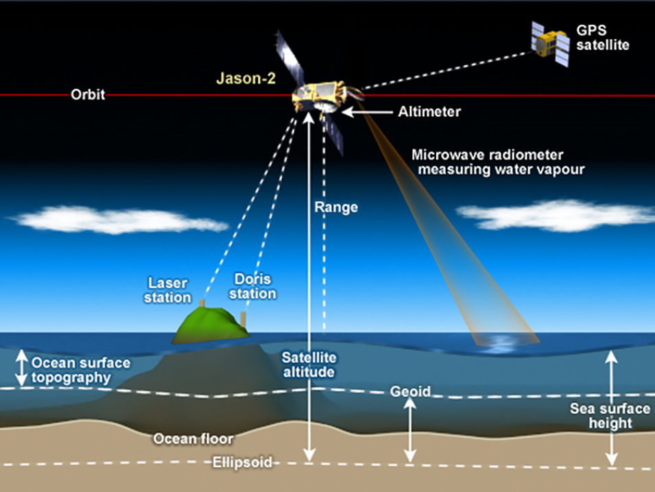
Satellite radar altimeters measure the ocean surface height (sea level) by measuring the time it takes a radar pulse to make a round-trip from the satellite to the sea surface and back. GPS satellites, like the one in the upper right corner of this image, are used to help locate the position of the altimetry satellite above Earth’s surface. Credit: NOAA.

"The way that the electricity is delivered to your house now is not the same as it was 50 years ago. There have been innovations and investments, all the little things that we usually don't hear about but that have been going on in the background to ensure consistent, reliable service," Craddock said. "In order to continuously serve our growing global user community we're trying to find innovations in how GNSS data can be used, how to help people understand and appreciate how government invests in GNSS, and how the global geodetic reference frame can yield ever-increasing returns."

According to Craddock, researchers are investigating "a lot of brilliant unanticipated uses of GNSS data," such as using GNSS satellite signals to inform tsunami early warning systems and in studies of climate change and sea level rise. "We’re not only working to ensure there is infrastructure and human capacity to maintain current operations but, on top of that, include all the new applications and technologies coming in," she said.

Given the pace at which those new technologies and new applications for GNSS data are being developed, it's a safe bet that the next 30 years of the IGS will be just as notable and expansive as the first.

Last Updated