Now Available in NASA Worldview: Earth Every 10 Minutes

The addition of GOES-East, GOES-West, and Himawari-8 geostationary imagery updated every 10 minutes lets you view Earth as it is “right now.”
author-share

Imagery from the Moderate Resolution Imaging Spectroradiometer (MODIS) instrument aboard NASA’s Terra and Aqua Earth observing satellites is great for tracking the movement of natural events over several days, like a hurricane churning across the ocean or a wildfire spreading through a forest. However, the one or two daily images provided by polar-orbiting satellites like Terra and Aqua are not the best resource for tracking rapidly-developing events as they happen in real-time, like a line of late-day severe storms popping or a wildfire’s sudden change in direction. For these situations you need constantly updated imagery showing the same location.

This geostationary imagery of Earth—updated every 10 minutes—is now available through NASA’s Global Imagery Browse Services (GIBS) for viewing using NASA’s Worldview interactive data visualization application.

Image
Image showing the GOES-R logo and the Himawari-8 logo side-by-side.
GOES-16, the first satellite in the GOES-R Series, launched on November 19, 2016, and is operational as GOES-East. GOES-17, the second satellite in the GOES-R Series, launched on March 1, 2018, and is operational as GOES-West. Himawari-8 launched on October 7, 2014. GOES-R logo courtesy of NOAA; Himawari-8 logo courtesy of the Japan Meteorological Agency.

Full-disk Earth imagery products from the joint NASA/NOAA Geostationary Operational Environmental Satellite-East (GOES-East) and GOES-West satellites along with full-disk imagery from the Japan Meteorological Agency Himawari-8 satellite enable storms, wildfires, and other events to be tracked as they are occurring across most of the globe (the only areas not covered are Europe, Africa, and the North and South Poles).

The same three imagery products are available for each satellite as part of this initial release: Red Visible, which can be used for analyzing daytime clouds, fog, insolation, and winds; Clean Infrared Product, which provides cloud top temperature and information about precipitation; and Air Mass RGB, which enables the differentiation between air mass types (e.g., dry air, moist air, etc.). “The geostationary field of view is always the same and the satellite sensor collects an entire hemispheric view every 10 minutes,” says Ryan Boller, the Data Visualization Lead for NASA’s Earth Science Data and Information System (ESDIS) Project. “This enables you to see things move in pretty much real-time and monitor changes much more closely than you can with an instrument aboard a polar-orbiting satellite.”

Image
Three side-by-side black and white images showing full disk Earth images acquired by GOES-East (left image), GOES-West (center image), and Himawari-8 (right image). All images show Earth as it appeared on September 24, 2019, and show clouds, storm systems, and fronts. GOES-East shows the Atlantic Ocean and Eastern U.S.; GOES-West shows Western U.S. and Pacific Ocean; Himawari-8 image shows Asia, Australia, and Pacific Ocean.
Examples of full disk hemispheric imagery available in NASA Worldview from GOES-East (left image), GOES-West (center image), and Himawari-8 (right image). All three images were acquired on September 25, 2019, and show Earth on September 24, 2019. Both GOES images are Red Visible; the Himawari-8 image is from the Infrared channel. GOES imagery courtesy of NOAA and available through NASA’s Marshall Space Flight Center, Earth Science Branch; Himawari-8 image courtesy of the National Institute of Information and Communications Technology (NICT) Science Cloud Project, Japan, and available through the Japan Meteorological Agency.

The availability of geostationary imagery in Worldview is the result of almost a year of collaborative work between NASA’s Short-term Prediction Research and Transition Center (SPoRT) located at NASA’s Marshall Space Flight Center in Huntsville, Alabama, and the ESDIS Project. SPoRT is a NASA- and NOAA-funded activity that develops ways for the operational weather community to use satellite observations and research capabilities to improve short-term regional and local weather forecasts. “Our goal in this effort was to help facilitate the use of geostationary data,” says Dr. Christopher Hain, the SPoRT Project Scientist. “The ability for these data to be displayed in Worldview is a real success story for our Earth Science Branch [at Marshall] and for SPoRT.”

The two GOES satellites and Himawari-8 are logical choices for providing this imagery. The instruments aboard all three satellites are built by the same company, so they are similar in construction. All three satellites acquire a full-disk image of Earth at the same time every 10 minutes during normal operation, which enables the imagery to be compared and analyzed easily.

Getting this imagery into GIBS for interactive viewing using Worldview is another instance of the long-running NASA/NOAA partnership. NASA provides launch capabilities to put NOAA satellites into orbit while NOAA manages and controls the satellites and produces the data and imagery. SPoRT acquires GOES data directly from a ground receiving station at Marshall and provides this data feed to GIBS for integration into Worldview. Himawari data are provided to NOAA through a data-sharing agreement with the Japan Aerospace Exploration Agency, and NOAA provides this imagery to SPoRT.

Image
Five-second black-and-white animation showing Hurricane Dorian rotating in a counter-clockwide direction off the east coast of Florida on September 2, 2019.
This animation showing Hurricane Dorian over the Bahamas on September 2, 2019, was created using seven hours of GOES-East Red Visible imagery. The change in light during the animation is caused by the change in Sun angle over time. Worldview enables animations to be created and shared easily. Animation courtesy of NASA Worldview.

The addition of geostationary imagery opens up a new way of using Worldview. “With geostationary imagery you can really look at the evolution of things like convection and tropical cyclones—especially when they’re undergoing rapid intensification,” says Dr. Hain. “Worldview is so nice and easy to use that it was a no-brainer for us when they showed interest in integrating the geostationary data into the system.”

Boller agrees that Worldview is a good interface for this imagery. “Worldview was designed to be highly responsive for interactive browsing, plus it has the capability to do playbacks and loops and then export these loops to video,” he says. “I think it was a perfect match of [SPoRT] wanting to have a newer interface for this imagery and us wanting to add this type of imagery. It’s a good fit for everybody.”

Worldview also enables geostationary imagery to be used with polar-orbiting imagery. For example, it is possible to overlay MODIS-detected thermal anomaly and hotspot location markers onto a GOES image and then go through a series of GOES 10-minute images to see how active fires develop and change over several hours.

While having full-disk geostationary imagery updated every 10 minutes is a boon to data users, it also represents a lot of data coming into GIBS/Worldview, and data storage will be used up quickly if every 10-minute image is kept. To manage this issue, at least initially, Boller and his team plan keep only the most recent month of imagery and are considering developing files related to specific large events, such as Hurricane Dorian. Hosting this imagery in the cloud is definitely an option, and one Boller says will be explored in the future.

For the present, though, being able to view and interactively explore geostationary imagery in Worldview is a real game-changer in how this application can be used. “It’s an easy case to make as to why you need geostationary data,” says Dr. Hain. “I know it required a bit of work at their end to deal with 10-minute data, but for Worldview users it will really be worth it.”

Ryan Boller couldn’t agree more. “I’m very excited to have Worldview show off this imagery,” he says. “It’s a real milestone to combine the strengths of geostationary and polar-orbiting spacecraft onto a single interactive map where you can see almost the entire world updated every 10 minutes!”

Learn more:

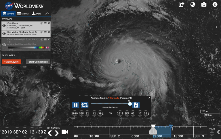
Interactively explore Hurricane Dorian using geostationary imagery in NASA Worldview.

Read more about this effort in the GIBS Blog.

Last Updated