Principal Investigator: Adrian Borsa: University of California San Diego Co-Investigators: Chaitanya Baru, Helena Fricker, Viswanath Nandigam, and Christopher Crosby: University of California, San Diego; Siri Jodha Khalsa: University of Colorado

NASA's Ice, Cloud, and land Elevation Satellite (ICESat) used laser altimetry to measure ice sheet mass balance, cloud and aerosol heights, topography, and vegetation from 2003 to 2009. ICESat-2, launched in November 2018, will use six laser beams to provide much denser measurements of the Earth’s surface. Data from these satellites can be used to study polar ice changes, biomass and carbon storage in vegetation, and forest characteristics, such as tree density.

OpenAltimetry is a cloud-ready, web-based application for discovery, access, and visualization of ICESat and ICESat-2 data. OpenAltimetry was developed by Adrian Borsa’s team at the University of California, San Diego, in cooperation with the San Diego Supercomputer Center and NASA's National Snow and Ice Data Center Distributed Active Archive Center (NSIDC DAAC).
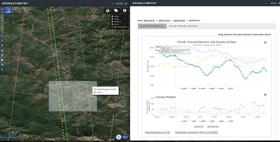
Screenshot of OpenAltimetry showing elevation selection.
Image Caption

A web application for map-based discovery and visualization of ICESat and ICESat-2 data, OpenAltimetry provides on-demand access to underlying datasets. The OpenAltimetry map interface shows a highlighted query box (left), and the elevation profile (right) for the ATL08 data within that area.

OpenAltimetry supports scientific research by providing quick, map-based discovery and visualization of altimetry data paired with on-demand access to the underlying datasets. It provides a hybrid solution for data management that incorporates a highly optimized PostgreSQL database with tiered storage and a decoupled object-based storage system for HDF5 files. This allows ICESat waveform energy data files and ICESat-2 photon data files to be stored in their original HDF5 format.

Open Altimetry is now operational for ICESat data, and the entire ICESat data set (GLAS/ICESat L1B Global Elevation Data, Version 34) is available for discovery and download. The project team is currently working with NSIDC DAAC to build a data workflow for ICESat-2 on existing services, to optimize user interfaces, and to make OpenAltimetry operational for real time ICESat-2 data flow.

Update

Elevations from the ICESat-2 Ocean (ATL12) and Sea Ice Products (ATL07, ATL10) are now available in OpenAltimetry, in addition to ATL03, ATL06, and ATL08.

Since launch, OpenAltimetry has been used for 2,688 ICESat-2 dataset downloads and 33,470 elevation plot downloads. As users interact with Open Altimetry, the team has made updates in response to user requests. New features include: zoom to specified coordinates, updates to the plotting package, and interactivity with Jupyter notebooks.

Read more about OpenAltimetry.

Publications

Nandigam, V., Borsa, A., Jodha Khalsa, S., Lin, K., Phan, M., Fricker, H. and Crosby, C. (2018). Access and Visualization of Spaceborne Altimetry Data from ICESat and ICESat-2. EGU General Assembly Conference Abstracts, 20.

Nandigam, V., Lin, K., Phan, M., Borsa, A., Jodha Khalsa, S., and Crosby, C. (2018). Rapid Access and Visualization of Spaceborne Altimetry Data from ICESat and ICESat-2. IGARSS 2018 - 2018 IEEE International Geoscience and Remote Sensing Symposium.

Presentations

Khalsa, SJ, Borsa, A., Nandigam, V., & Phan, M. (2019, May) Services for Exploring NASA’s ICESat and ICESat-2 Data. Presented at the European Space Agency’s 2019 Living Planet Symposium, Milan, Italy.