We are in the process of migrating all NASA Earth science data sites into Earthdata from now until end of 2026. Not all NASA Earth science data and resources will appear here until then. Thank you for your patience as we make this transition.
Read about the Web Unification Project
OPERA Learning Resources
Webinars, tutorials, data recipes and more to help you work with OPERA.
Learn
Filters

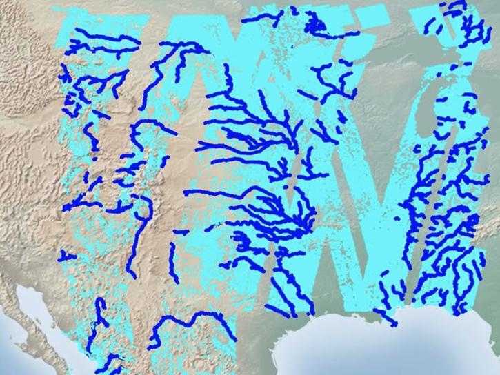
This three-part ARSET training covers flood monitoring via remote sensing, NASA flood products, and GEOGLOWS streamflow predictions.
Training
June 18-25, 2026

This ARSET training covers how data from GRACE/GRACE-FO, OPERA-DISP, and GLDAS can be used to assess groundwater changes.
Training
April 23-30, 2026
Follow this step-by-step tutorial to upload data into popular and versatile Geographic Information Systems (GIS) programs.
Tutorial
Nov. 17, 2025

Access resources for exploring and working with OPERA Surface Displacement from Sentinel-1 (DISP-S1) products from NASA’s Alaska Satellite Facility Distributed Active Archive Center (ASF DAAC).
StoryMap
Sept. 2, 2025

NASA Jet Propulsion Laboratory's Observational Products for End-Users from Remote Sensing Analysis (OPERA) project is hosting a half-day virtual workshop on Thu Sept. 11, 2025, to offer product updates, previews, and more.
Webinar
Aug. 27, 2025

Using SNWG's OPERA DSWx product, USGS is able to monitor streamflow from space, augmenting hazardous in-person collection techniques.
Data in Action
July 8, 2025

Join us on Thursday, May 29, to learn about the NASA JPL OPERA Surface Displacement (OPERA-DISP) dataset and how to access and explore the data using ASF DAAC's Displacement Portal.
Webinar
May 14, 2025
Work with data from the NASA/ISRO (Indian Space Research Organization) Synthetic Aperture Radar (NISAR) platform in ArcGIS Pro with data from NASA's Alaska Satellite Facility Distributed Active Archive Center (ASF DAAC).
StoryMap
Feb. 26, 2025
SHOWING 8 OF 19