The Japanese Earth Resources Satellite (JERS-1) was launched by JAXA (Japan Aerospace Exploration Agency) aboard a Japanese H-1 launcher. The platform carried an L-band (HH polarization) synthetic aperture radar (SAR) and a nadir-pointing optical sensor (OPS). Using its high-resolution, all-weather SAR, JERS-1 was used to map important forests of the world: Southeast Asia, Africa, Central America, South America (Amazon Basin), and Boreal North America.

Type

Synthetic Aperture Radar

Data Center

ASF DAAC

Launch

February 11, 1992

Objective

Gather data on global land masses.
JAXA
JERS-1 is a JAXA (Japan Aerospace Exploration Agency) mission. NASA distributes JERS-1 synthetic aperture radar (SAR) data through the Alaska Satellite Facility Distributed Active Archive Center (ASF DAAC).

JERS-1 carried an L-band (HH polarization) synthetic aperture radar (SAR).

Center Frequency1.275 GHz (L-band, 23.5 cm wavelength)
Bandwidth15 MHz
Spatial Resolution18 m (range) x 18 m (azimuth, 3 looks)
Swath Width175 km
Transmitting Power35 µs
Pulse Repetition Frequency (PRF)1505.8 - 1606.0 Hz
Antenna
Polarization
Look Angle
Antenna Gain
Signal to Ambiguity Ratio
Array of 1024 microstrip radiation elements
HH
35.21°
>33.5 dB
>14 dB
Data Quantization3 bits
Data Rate3 Mbit/s

The JERS-1 optical sensor (OPS) was a nadir-pointing multi-spectral imager.

Band NoSpectral RangeGeneral Application
10.52 - 0.60 µm VIS (green)Vegetation surveys, land use, water monitoring
20.63 - 0.69 µm VIS (red)Chlorophyll absorption for vegetation differentiation
30.76 - 0.86 µm NIRBiomass surveys (nadir viewing)
40.76 - 0.86 µm NIRBiomass surveys (forward looking, at 15.3º to give stereo coverage with band 3)
51.60 - 1.71 µm (SWIR)Vegetation moisture
62.01 - 2.12 µm (SWIR)Hydrothermal mapping (eg. soils; geology)
72.13 - 2.25 µm (SWIR)Hydrothermal mapping (eg. soils; geology)
82.27 - 2.40 µm (SWIR)Hydrothermal mapping (eg. soils; geology)

Two JERS-1 datasets are distributed by NASA:

DatasetDescription
L0_JERS-1Unprocessed/Raw Data
L1_JERS-1Amplitude Imagery — Processed Images


 The Level 0 and Level 1 products are restricted datasets, and researchers must have permission to download data. Researchers must currently be living in the United States. For information contact the NASA Alaska Satellite Facility Distributed Active Archive Center (ASF DAAC) User Support Office.

The following open access image mosaics also are available:

  • Amazon Low Flood
  • Amazon High Flood
  • North America Winter Texture
  • North America Summer Texture
  • North America Summer Backscatter
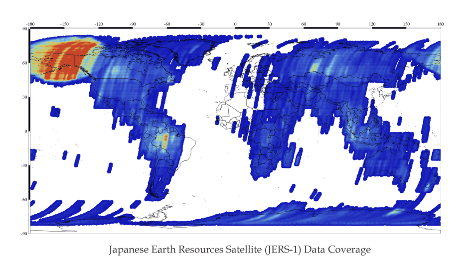
Global map with blue/yellow/red colors indicating swaths of JERS-1 data
Image Caption

Global map showing JERS-1 Level 1 product coverage available through NASA's ASF DAAC. JERS-1 data can be downloaded (after filling out an agreement) at ASF's Vertex data portal (vertex.daac.asf.alaska.edu).

JERS-1 products can be accessed using several tools available through NASA's ESDS Program:

Data Discovery ToolLink
NASA Earthdata SearchJERS-1
ASF Vertex Data SearchVertex
Python Search Moduleasf_search
ASF Search APIASF Search API


How to Cite JERS-1 Data and Imagery

Dataset ProductHow to CiteFormatExample
JERS-1 DataCite data in publications such as journal papers, articles, presentations, posters, and websites. Please send copies of, or links to, published works citing data, imagery, or tools accessed to NASA's ASF DAAC User Services Office at uso@asf.alaska.edu with “New Publication” on subject line.Dataset: JERS-1, JAXA [year of data acquisition]. Retrieved from ASF DAAC [day month year of data access].Dataset: JERS-1, JAXA 1994. Retrieved from ASF DAAC 21 June 2015.
JERS-1 ImageryInclude credit with each image shown in publications such as journal papers, articles, presentations, posters, and websites.© JAXA [year of data acquisition]© JAXA 1994

Frequently Asked Questions

Earthdata Forum

Our online forum provides a space for users to browse thousands of FAQs about research needs, data, and data applications. You can also submit new questions for our experts to answer.

Submit Questions to Earthdata Forumand View Expert Responses

Earthdata
Forum