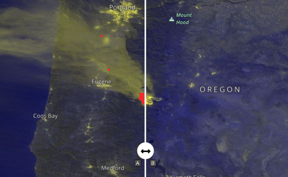
The map above shows Black Marble Nighttime Blue/Yellow Composite (Day/Night Band) imagery of the Cedar Creek Fire in Oregon on September 10, 2022. This image was acquired by the Visible Infrared Imaging Radiometer Suite (VIIRS) aboard the joint NASA/NOAA Suomi National Polar-orbiting Partnership (Suomi NPP) satellite. The fire is visible southeast of Eugene and Portland.
Click on the image to visit Worldview to swipe the center bar left and right to see how the active fire detections in red on the left correspond to the yellow "night lights" in the image of the same night on the right. This is in sharp contrast to all of the other yellow nighttime lights emanating from surrounding cities, towns, and major roadways.
Also visible is the smoke from the fire blowing westward. According to the InciWeb Incident Information System, the fire started on August 1, 2022 as a result of lightning strikes starting 20 to 30 new fires in the Willamette National Forest.
The Black Marble Nighttime Blue/Yellow Composite (Day/Night Band) layer is a false color composite created using the VIIRS at-sensor radiance and the brightness temperatures from the M15 band. The false color scheme produces nighttime city lights and active fires in shades of yellow and nighttime cloud presence in shades of blue. During bright moonlight conditions, moonlight reflected from cloud tops and the land surface may also provide a yellow hue to these features.
Learn more about the Blue/Yellow composite: New Black Marble Nighttime Blue/Yellow Composite Product Makes Detecting Power Outages Easier
Learn more about nighttime lights data and imagery: Nighttime Lights Backgrounder
Visit Worldview to visualize near real-time imagery from NASA's EOSDIS, and check out more Worldview weekly images in our archive.
Reference: Cedar Creek Fire. InciWeb. Accessed September 13, 2022.
