Any great voyage of discovery begins with a first step. Or, in the case of a satellite mission, a successful launch. For NASA’s Terra Earth observing satellite, this journey began on December 18, 1999, with its launch into a sunny sky over Vandenberg Air Force Base on the California coast northwest of Santa Barbara.
Terra: The Hardest Working Satellite in Earth Orbit
On October 6, 2018, after nearly 19 years in space, Terra completed its 100,000th orbit. During its journey, Terra has traveled about 2.5 billion miles (that’s more than 450,000 round-trip flights between New York City and San Francisco, CA). Even more significantly, all major spacecraft systems are working fine and its five instruments continue to send back a steady stream of science-quality data.
The story of how the Terra spacecraft made it to this milestone and the challenges of keeping its 20th century systems operating is well-told in an article by the Terra team. This article tells the other half of the Terra story: the story of how Terra instrument data are brought back to Earth and turned into data products that constitute one of the longest continuous data records of our planet ever recorded from space.
“To have this much technology still operating after so much time in space is incredible,” says Greg Dell, the NASA Earth Science Mission Operations (ESMO) Project Deputy Director-Operations. “And the data are still relevant; it’s not like we’ve gotten leaps and bounds better quality data or next-generation spacecraft that have made Terra obsolete. People still want these data.”
The Flagship Mission of NASA’s Earth Observing System (EOS)
Terra was the first mission in NASA’s Earth Observing System (EOS). Conceived in the 1980s and implemented in the 1990s, the EOS comprises an integrated collection of satellites, a science component, and a data system. The overall EOS objective is to provide a better understanding of the total Earth system and the effects of natural and human-induced changes on the environment through long-term global observations.
“Terra was the first of what was supposed to be three satellites,” says Eric Moyer, the ESMO Project Deputy Director-Technical. “The plan was to launch AM-1, which was Terra, followed by an AM-2 and an AM-3 [satellite]. The three satellites together, with an expected five-year lifespan each, would be combined to generate a 15-year climate data record. While AM-2 and AM-3 were never built, we still achieved this [data record] with just one satellite—Terra.”
Five instruments are aboard the Terra spacecraft:
- Advanced Spaceborne Thermal Emission and Reflection Radiometer (ASTER), which is a partnership between NASA, Japan’s Ministry of Economy, Trade and Industry (METI), the National Institute of Advanced Industrial Science and Technology (AIST) in Japan, and Japan Space Systems (J-spacesystems);
- Clouds and the Earth’s Radiant Energy System (CERES), which was built at NASA’s Langley Research Center in Hampton, Virginia;
- Measurement of Pollution in the Troposphere (MOPITT), which was jointly developed by the Canadian Space Agency, the University of Toronto, and the National Center for Atmospheric Research (NCAR) in Boulder, Colorado;
- Moderate Resolution Imaging Spectroradiometer (MODIS), which was developed at NASA’s Goddard Space Flight Center in Greenbelt, Maryland; and
- Multi-angle Imaging SpectroRadiometer (MISR), which was developed at NASA’s Jet Propulsion Laboratory in Pasadena, California.
Terra began returning data from all instruments in early 2000. Aside from the failure of ASTER’s Short-Wave InfraRed (SWIR) system, all instruments continue to provide good quality science data.
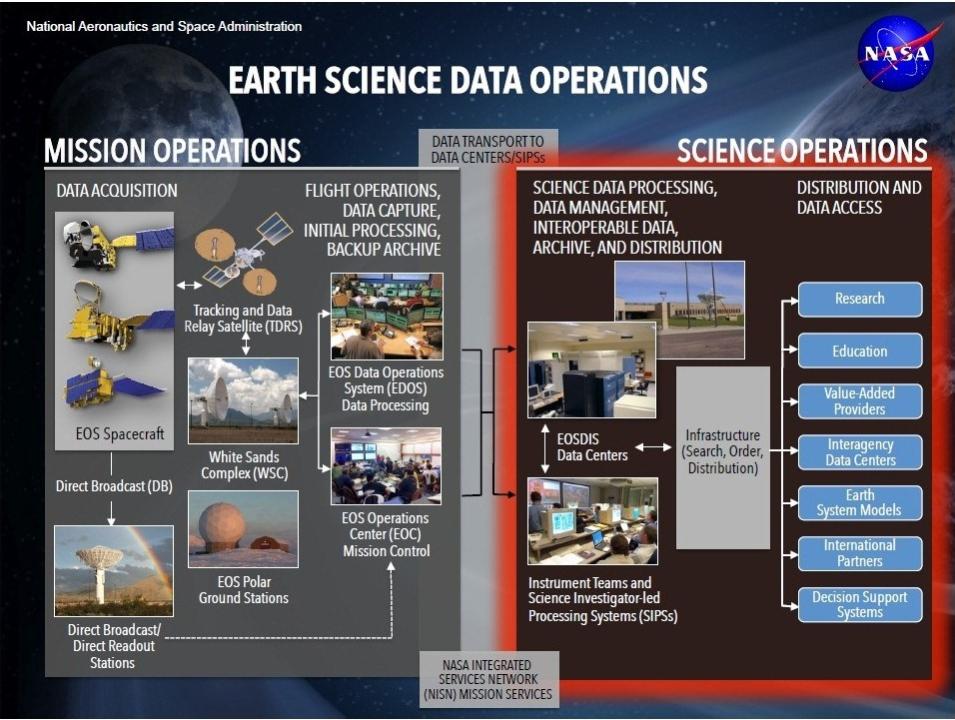
EOSDIS Mission Operations are managed by the ESMO Project (left side of illustration). Satellite instrument data are processed into Level 0 data by the EOS Data Operations System (EDOS) and sent to the ESDIS Project (right side of illustration) for processing into Level 1-4 products, archiving, and distribution. This higher-level data processing is done primarily by Science Investigator-led Processing Systems (SIPS); processing for selected instruments is done by individual instrument processing teams at EOSDIS Distributed Active Archive Centers (DAACs). The NASA Integrated Services Network (NISN) (bottom center of illustration) is a global system of communications transmission, switching, and terminal facilities that provides NASA with wide area network (WAN) communication services and facilitates data transmission. NASA EOSDIS illustration.
Since Terra is an EOS satellite, its data are the responsibility of NASA’s Earth Observing System Data and Information System (EOSDIS). The EOSDIS provides end-to-end management of NASA Earth science data from sources including satellites, aircraft, field measurements, and other programs, and is a core capability of NASA’s Earth Science Data Systems (ESDS) Program.
EOSDIS is divided into Mission Operations and Science Operations. Mission Operations are managed by NASA's Earth Science Mission Operations (ESMO) Project, which is responsible for the maintenance and operation of Terra and other EOS spacecraft along with Earth science missions conducted by NASA’s Earth Science Projects Division (ESPD).
Within ESMO, overall satellite command and control, satellite and instrument health assessment, and the scheduling of satellite commands are the responsibility of NASA's EOS Mission Operations System (EMOS). Instrument data capture and initial (Level 0) processing of instrument data are the responsibility of NASA's EOS Data Operations System (EDOS).
Level 0 instrument data are sent from EOSDIS Mission Operations to EOSDIS Science Operations for higher level processing, archiving, and distribution. EOSDIS science operations are managed by NASA's Earth Science Data and Information System (ESDIS) Project. ESDIS responsibilities include processing data into Level 1-4 standard data products, which are archived at and distributed through an integrated network of discipline-specific Distributed Active Archive Centers (DAACs). A majority of higher-level data processing is done by Science Investigator-led Processing Systems (SIPS), which are under the direct control of instrument Principal Investigators/Team Leaders or their designees (this is the case for Terra MODIS and MOPITT instrument data products). Along with the SIPS, standard products for some instruments are produced directly by teams at the DAACs (this is the case for Terra ASTER, CERES, and MISR instrument data products).
In addition, data and service metadata records are incorporated into the EOSDIS Common Metadata Repository (CMR), which is the authoritative management system for all EOSDIS metadata and facilitates search and discovery through the entire EOSDIS data collection.
From Terra to Terabytes: Getting Data Back from Space
Getting Terra instrument data back from the spacecraft is the responsibility of NASA's EOS Data Operations System (EDOS). EDOS has been performing continuous data capture and initial (Level 0) processing for Terra data since 1999. “The primary focus [of EDOS] is to capture the data, make sure it’s of good quality, and then send it off to the different EOSDIS DAACs and SIPS for higher level processing,” Moyer says.
Primary overall EDOS tasks include:
- Capturing spacecraft instrument science data at ground stations and performing front-end processing on these data;
- Transferring science data to Goddard;
- Performing Level 0 science data processing at a centralized Level Zero Processing Facility (LZPF) at Goddard; and
- Delivering Level 0 products in a variety of formats and protocols for higher level processing.
The EDOS ground system was built in the early-1990s for Terra data capture, but was designed from the start to be modular, flexible, and scalable to support multiple mission operations. “The modularity and scalability of EDOS is truly significant, and enables us to easily add new missions to the system,” says Terri Wood, EDOS Project Manager. “It’s very easy to scale the ground system to handle a new mission or new mission requirements. If you have a network, we can deliver science data.”
Along with Terra, EDOS currently supports seven other missions: the NASA Aqua, Aura, Orbiting Carbon Observatory-2 (OCO-2), Soil Moisture Active Passive (SMAP), and Ice, Cloud and land Elevation Satellite-2 (ICESat-2) and the joint NASA/NOAA Suomi National Polar-orbiting Partnership (Suomi-NPP) and Joint Polar Satellite System-1 (JPSS-1, now known as NOAA-20).
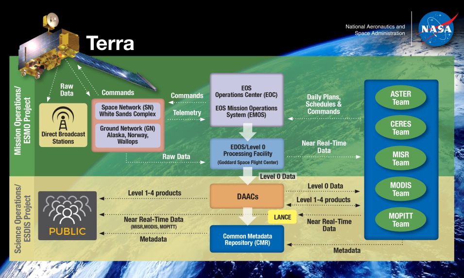
Simplified Terra ground system diagram. Direct Broadcast (DB) provides real-time MODIS data to more than 240 worldwide ground stations. Near Real-Time (NRT) data are available through the EOSDIS Land, Atmosphere Near real-time Capability for Earth observations (LANCE) system, which provides MISR, MODIS, and MOPITT instrument data generally within three hours of a satellite overpass. Illustration based on a NASA EDOS diagram. Click on image for larger view.
Terra data are downlinked twice each orbit using NASA’s Tracking and Data Relay Satellite System (TDRSS) to a ground station at NASA's White Sands Complex in White Sands, New Mexico. While Terra can transmit science data via ground stations located in Alaska, Norway, and at NASA's Wallops Flight Facility in Wallops Island, Virginia, (and does so for contingency purposes), Terra primarily transmits science data via TDRSS to White Sands.
One significant evolution for Terra data capture has been the shift from schedule-driven to data-driven data acquisition. Unlike schedule-driven acquisition, where data could be lost due to changes in the system or poor communications at a scheduled data acquisition time, data-driven acquisition means the system is always listening for Terra data. “If a data bit [from Terra] hits the antenna, EDOS will capture it,” says Greg Dell. “This gives the team the flexibility of doing blind data acquisitions. EDOS will capture the data even if you were not planning to capture data on a particular pass.”
The system also ensures that no Terra data are lost during a downlink. “The system is looking for frame syncs,” says Bruce McLemore, EDOS Contractor Project Lead. “If the spacecraft ID and the frame sync match [one of our] supported missions it will lock onto the satellite and start collecting data. Not only this, but the five or six frames that came in before the ground station locks on to the satellite will be looped back through so we don’t lose any data. It’s a very spiffy design.”
From the ground station, raw satellite data are sent via high speed communications links to NASA's EDOS Level Zero Processing Facility (LZPF) at Goddard. These Level 0 data are then sent to EOSDIS DAACs where they are retrieved by DAAC instrument teams and SIPS for processing into higher level products (ASTER Level 0 data are sent to the ASTER ground system in Japan for processing into Level 1A and 1B data, then to NASA's Land Processes DAAC (LP DAAC) for higher level processing).
Terra Data Latency and Real-Time Data Capability
While the Terra instruments have not changed since their launch in 1999, technologies for delivering instrument data have. In the late-90s, physical data tapes still had to be shipped back from ground stations for initial processing, a process that could take as long as five to seven days. This significantly impacted the time it took for data to get from satellite to data user, which is called “latency.” “When Terra was launched, the goal for the science data was long-term trending and producing a long-term climate record,” says Greg Dell. “Now, it’s how quick can you get us the data. This is a big paradigm shift over the course of the mission. We’ve been able to accommodate this paradigm shift with ground automation and better, faster networks.”
A high objective of the EDOS team is to reduce latency and provide Level 0 data as quickly as possible to the DAACs. “We’ve worked very hard to reduce any bottlenecks in getting the data [from the satellite] to the ground station then from the ground station to [Goddard] for initial processing and then to the end user,” says Terri Wood. “We continually try to reduce our latency.”
One significant improvement in data delivery is the ability to use a flexible network infrastructure. Data traditionally were transferred over a high-rate closed network. These types of networks provide security, but have a lower bandwidth. The alternative is an open network, which has higher bandwidth, but requires that data be fully encrypted for security before they are sent. Over time, the EDOS team developed the necessary security and capability to flow data over open internet connections. Now, both a closed and an open network are available for moving data—redundancy that ensures that all instrument data are captured at ground stations and sent back to Goddard rapidly and securely for initial Level 0 processing.
Along with using open networks, EDOS also moved to a low-latency protocol. “Our goal is to move the data across the network as fast as it’s coming down from the spacecraft,” says Bruce McLemore. “Switching to a low-latency protocol over an open network allows us to easily keep up with the Terra data.”
A unique feature of Terra is its Direct Broadcast (DB) capability, which enables anyone with a receiver to download raw MODIS data in real time. Today, more than 240 registered stations around the world receive and process Terra DB MODIS data. “It’s all the MODIS data packaged in the raw format,” explains Eric Moyer. “For a lot of countries that don’t have a space program, it doesn’t cost a whole lot to put up an antenna and capture the DB data and process it in real-time or near real-time so they can see how things are going in their area. It’s very beneficial.”
In addition to DB real-time data, NASA's EOSDIS Land, Atmosphere Near real-time Capability for Earth observations (LANCE) system provides near real-time (NRT) data for Terra’s MISR, MODIS, and MOPITT instruments (along with NRT data for more than a half-dozen other instruments). LANCE data generally are available within three hours of a satellite observation. While Terra LANCE and DB data do not have the processing, validation, or quality assurance required for use in scientific research, they are an invaluable resource for managing on-going events.
The Terra Data Record
Terra’s data are its legacy, and the Terra data record represents one of the longest satellite climate data records ever compiled. While Terra has completed 100,000 orbits, it downlinked to transmit data twice each orbit—that’s 200,000 downlinks. “To me, that’s even more significant,” says Bruce McLemore. “Some of these spacecraft downlink only once per orbit. Some in the future may be only, say, eight times per day."
Along with near real-time MISR, MODIS, and MOPITT data products distributed through LANCE, Terra Level 1-4 standard data products are archived at and distributed through numerous EOSDIS DAACs. ASTER data products are available through the LP DAAC, which operates as a partnership between NASA and the U.S. Geological Survey (USGS) and is located at USGS Earth Resources Observation and Science (EROS) Center; CERES, MISR, and MOPITT data products are available through NASA's Atmospheric Science Data Center (ASDC).
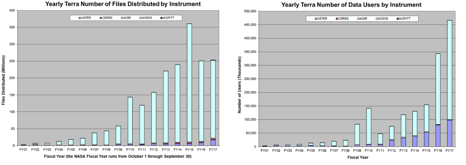
EMS metrics showing the distribution of Terra instrument data (left table) and the number of unique worldwide data users (right table) from Terra’s launch through September 30, 2017. MODIS data products, aqua-colored bar, continue to be the most popular Terra products, both in terms of distribution and unique data users. The spike in MODIS files distributed in Fiscal Year (FY) 2015 is due to a reprocessing of the entire MODIS data collection—data users were downloading both MODIS Collection 5 and Collection 6 during this time. The noticeable decline in unique MODIS users between FY10 and FY11 is due to a decrease in the number of MODIS data users in China. The EMS attributes this decrease to two factors: The use of better Domain Name System (DNS) look-up tables to identify unique users and a real decline in actual users of MODIS data in China. NASA EOSDIS graphics and metrics. Click on image for larger view.
MODIS land products are available through LP DAAC, while ocean color products are available through NASA's Ocean Biology DAAC (OB.DAAC), and Level 1 and atmosphere products are available through NASA's Level 1 and Atmosphere Archive and Distribution System DAAC (LAADS DAAC). Additional MODIS data products are available through NASA's Goddard Earth Sciences Data and Information Services Center (GES DISC), NASA's Global Hydrology Resource Center DAAC (GHRC DAAC), NASA's National Snow and Ice Data Center DAAC (NSIDC DAAC), and NASA's Physical Oceanography DAAC (PO.DAAC). Four MODIS Land Product Subsets also are available through NASA's Oak Ridge National Laboratory DAAC (ORNL DAAC).
As of the end of NASA’s 2017 Fiscal Year (the most recent year for which complete data are available), the total volume of Terra data in the EOSDIS archive is more than 5 petabytes (PB), according to metrics from NASA's ESDIS Metrics System (EMS). To put this into perspective, 1 PB is equivalent to about 20 million 4-drawer filing cabinets full of text. In addition, Terra data are some of the most popular EOSDIS data products. Almost 2 billion Terra data files from all instruments have been distributed to more than 1.6 million unique worldwide data users between when Terra data were first available in 2000 through September 30, 2017 (the end of the 2017 Fiscal Year).
The Future of the Terra Journey
Space is a harsh environment, and the fact that the Terra spacecraft and its five instruments have operated for far longer than their planned six-year life is a phenomenal accomplishment. Barring unforeseen incidents, Terra’s instruments are expected to continue to collect data that will be added to the EOSDIS archive. Fuel, however, is the limiting factor, and Terra will only be able to maintain its 438-mile (705 km) science orbit for another few years.
As the satellite runs out of the fuel it needs to maneuver, its orbit gradually will lower and the instrument data will no longer have the validity needed for scientific research or be considered climate record data. “When we say that we won’t be able to maintain the orbit, we mean we won’t be able to maintain the satellite crossing the equator at 10:30 am [local time at the equator],” says Greg Dell. “As the satellite orbit lowers, it will cross the equator at an earlier time. You also can’t maintain the same inclination, or tilt, relative to the sun. Once you drift far enough [off orbit], your sun angle is different and your science data become less useful.”
“It’s no longer climate record data,” adds Eric Moyer. “It’s still good data, but it’s no longer climate record quality because we’re no longer collecting these data at the same angle relative to the sun.”
For researchers, the science quality Terra instrument data in the EOSDIS archive constitute an invaluable almost two-decade-long record of a wide range of Earth processes. These data, along with all data algorithms and supporting documentation, are archived by ESDIS and available to worldwide data users under NASA’s free and open data policy. “It’s nice to say 100,000 orbits, but from the science side, this means 18 years of good, continuous data,” says Moyer.
For NASA’s EOSDIS, Terra sets the bar high for future missions that will build on its success. “It really is a testament to great work by the entire team for being able to keep this spacecraft up in the air and healthy and to be able to produce like it has,” says Terri Wood. “It’s people, processes, and programs that make this happen. I just think it’s a real testament to what we can do around here.”
