Providing ACCESS to EOSDIS Data

NASA’s ACCESS Program helps create and enhance technologies that make EOSDIS data more accessible for global interdisciplinary research.

New technologies are constantly being created within the user community that can improve access to and use of the more than 27.5 petabytes (PB) of Earth observing data in NASA’s Earth Observing System Data and Information System (EOSDIS) collection. Partnerships with the academic, developer, and user communities (not to mention participation in organizations such as the Committee on Earth Observation Satellites [CEOS] and the Earth Science Information Partners [ESIP] federation) enable the EOSDIS to evaluate innovative systems, applications, and programs to see how they might be applied to EOSDIS data. An important NASA initiative for facilitating these partnerships is the Advancing Collaborative Connections for Earth System Science (ACCESS) Program.

Established in 2005, ACCESS is a competitive program within NASA’s Earth Science Data Systems (ESDS) Program. The ESDS Program oversees the life-cycle of NASA’s Earth science data—from acquisition through processing and distribution. It accomplishes this through the EOSDIS, which provides end-to-end capabilities for managing these data.

The overall objective of ACCESS is to help develop and implement technologies for effectively managing, discovering, and utilizing NASA Earth observing data for scientific research and applications. Projects selected for ACCESS enhance NASA’s data system components by enabling the rapid deployment of data system services to help bridge specific gaps within the agency’s Earth science information systems. Since its inception, more than 70 projects have been part of the program; five projects are part of the current ACCESS 2017.
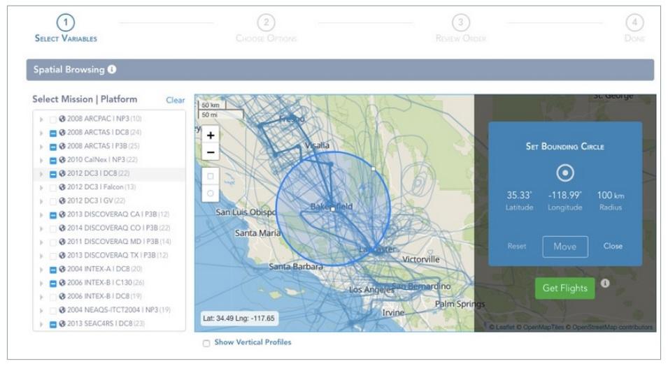
Screenshot of STA3CD ACCESS 2015 project.
Image Caption

Screenshot from the Subsetting Tools for Advanced Analysis of Airborne Chemistry Data (STA3CD, or “Stacked”) ACCESS 2015 project. STA3CD enhances the Toolsets for Airborne Data (TAD) system developed by NASA’s Atmospheric Science Data Center (ASDC) with additional geographical map capabilities to better serve the research community.

ACCESS Principal Investigators (PIs) work closely with NASA’s Earth Science Data and Information System (ESDIS) Project to integrate their projects into the discipline-specific Distributed Active Archive Centers (DAACs) that archive and distribute EOSDIS data. For example, the ACCESS 2011 Curated Data Albums for Earth Science Case Studies project is in use at the Global Hydrology Resource Center (GHRC) DAAC and OpenAltimetry, an ACCESS 2015 project, is helping facilitate the analysis of data from NASA’s ICESat and ICESat-2 missions at the National Snow and Ice Data Center (NSIDC) DAAC. In addition, the 10 ACCESS 2015 projects, which concluded in 2018 with presentations of their final work, resulted in more than 30 professional publications. Regardless of whether technology developed through an ACCESS project is integrated into EOSDIS, these projects help NASA better understand the proposed technology solution and its utility for future consideration.

ACCESS solicitations are generally released every other year as part of NASA’s Research Opportunities in Space and Earth Sciences (ROSES) research program. Each ACCESS solicitation has a specific goal or objective reflecting the needs of both NASA data systems and EOSDIS data users. For example, the goal of ACCESS 2017 was “to improve and expand the use of NASA’s Earth science data by leveraging modern techniques for discovering, managing, and analyzing large and complex Earth science data sets,” with specific focus areas in machine learning, advanced search capabilities, and cloud-optimized preprocessing and data transmission.

Out of 39 submissions, five proposals were selected for ACCESS 2017:

  • Community Tools for Analysis of NASA Earth Observation System Data in the Cloud
  • Data Access and the ECCO Ocean and Ice State Estimate
  • Multi-Temporal Anomaly Detection for SAR Earth Observations
  • STARE: SpatioTemporal Adaptive-Resolution Encoding to Unify Diverse Earth Science Data for Integrative Analysis
  • Systematic Data Transformation to Enable Web Coverage Services (WCS) and ArcGIS Image Services within ESDIS Cumulus Cloud

The formal ACCESS 2019 solicitation is expected to be released in November as part of NASA’s ROSES-2019 omnibus solicitation (NNH19ZDA001N), and will be available through the NASA Solicitation and Proposal Integrated Review and Evaluation System (NSPIRES) website.

As noted by NASA’s ESDS Program, ACCESS projects increase the interconnectedness and use of information technology software and techniques that help advance Earth science research and applications. These projects also further enhance the free and open exchange of EOSDIS data and information, which is a critical objective of NASA’s Earth Science Division. Through partnerships fostered through the ACCESS Program, new and innovative technologies for accessing and using NASA Earth science data are constantly available to the millions of worldwide EOSDIS data users.

Details

Last Updated

Published

Data Center/Project

Global Hydrometeorology Resource Center DAAC (GHRC DAAC)
National Snow and Ice Data Center DAAC (NSIDC DAAC)