Data Tool in Focus: OpenAltimetry

OpenAltimetry lets users explore changes on Earth’s surface around the globe and over time, and all they need is a web browser.
An image from OpenAltimetry showing the ICESat-2 orbit tracks and data-acquisition points along the northern end of Lake Michigan on March 11, 2023.
Image Caption

A screen capture of the OpenAltimetry user interface showing ICESat-2 orbit tracks (green lines) and data acquisition points (green and yellow dots) near Maple City, Michigan, along the northern end of Lake Michigan on March 11, 2023. Credit: OpenAltimetry/NASA's NSIDC DAAC.

Given its name, it's tempting to think that NASA’s ICESat satellite, which traveled around Earth in a polar orbit from 2003 to 2009, was singularly focused on the planet's cryosphere. On the contrary, ICESat—an acronym for Ice, Cloud, and land Elevation Satellite—was the benchmark NASA Earth Observing System (EOS) mission for measuring land topography, vegetation characteristics, cloud and aerosol heights, and, yes, ice in polar regions.

The same can be said for ICESat-2, the second-generation satellite of the ICESat mission, which launched on September 15, 2018. At the heart of both the ICESat and ICESat-2 missions are laser altimetry systems designed to measure the time it takes laser pulses to travel from the spacecraft to Earth's surface and back—data that can then be used to produce detailed images of the elevation of the planet’s vegetation, land, water, clouds, and ice.

There are several ways users can visualize ICESat and ICESat-2 data, but one of the easiest and most accessible is with OpenAltimetry (OA), a web-based data visualization and discovery tool offering an easy-to-use map-based method of exploring surface elevation profiles from the ICESat missions.

OA began as an Advancing Collaborative Connections for Earth System Science (ACCESS) program-funded collaboration between Scripps Institution of Oceanography, San Diego Supercomputer Center at the University of California San Diego, EarthScope Consortium (formerly UNAVCO), and NASA's National Snow and Ice Data Center Distributed Active Archive Center (NSIDC DAAC). Recently, it was moved to NASA's Earthdata Cloud, where users can explore and work with ICESat mission data without the need to download individual files, saving time and the need for increased computational power.

"As you can imagine, both the ICESat and ICESat-2 missions have yielded huge volumes of data. It's impractical for researchers to download all of those files and then try to somehow visualize them all on their computers," said Dr. Mikala Beig, the NSIDC DAAC user services data support specialist. "OpenAltimetry gives users a way to really target an area of interest and determine which dates have data, and then it serves up the relevant data products. This makes it an indispensable tool for users in the data exploration phase of their research."

Further, by requiring nothing more than a web browser to use it, the OA tool helps those new to the ICESat missions learn about both the science and concepts of altimetry and the data ICESat and ICESat-2 provide.

"[OA] shows the satellite orbit paths and the laser pulses, which we refer to as 'blue dots.' Then, as users zoom in further, they get more and more information from the [application] to the point that they can see where [the lasers are] hitting and where they're not hitting," said Kristin Rowley, a NSIDC DAAC project manager. "OA really helps them better understand what’s happening with the data because [users] can see exactly where the laser has bounced off the surface of Earth."

Using the OpenAltimetry Tool

OA offers users access to ICESat's Geoscience Laser Altimeter System (GLAS) Level1B Global Elevation Data product (GLAH06) and seven products produced from data acquired by the ICESat-2 mission's Advanced Topographic Laser Altimeter System (ATLAS): Global Geolocated Photon Data (ATL03), Land Ice Height (ATL06), Sea Ice Height (ATL07), Land and Vegetation Height (ATL08), Sea Ice Freeboard (ATL10), Ocean Surface Height (ATL12), and Inland Water Surface Data (ATL13).

To begin using OA, users must choose between the ICESat and ICESat-2 missions (data from both satellites cannot be viewed simultaneously in the same map view). After a data source has been selected, users are presented with a map of Earth’s surface with no altimetry data showing. For the data to load, users must zoom in on the map until the satellite tracks (peach and green lines) and data-acquisition points (blue dots) appear.

Within the map interface users will see a vertical toolbar on the left side of the screen and a horizontal toolbar in the upper right corner. Hovering over the icons in both toolbars will display a brief description of each tool's function. The left-side map tools include buttons to zoom in or out and reset the default map display. From left to right, the top-right map tools include:

  • A globe icon that allows users to choose the map projection: Geographic (global), Arctic, and Antarctic
  • A tags icon that allows users to annotate the map (this requires logging in to an Earthdata account.)
  • An information icon (i.e., the letter “i” in a circle) that allows users to select from a variety of map base layers
  • An envelope icon for contacting the OA team with questions or comments

For ICESat data, an interactive data slider bar on the bottom of the screen shows the full data date range. Users can adjust the date range by clicking on the date rectangle located at each end of the bar and dragging it across the slider.

Once users have their geographic area of interest, an additional tool appears in the top left corner of the map—the "Select a Region" button. This button allows users to select multiple data-observation points at a time from the resulting pop-up window.
An image of the Grand Canyon in OpenAltimetry that shows the satellite tracks, acquisition points, and, inset, a graphic depicting the change in land surface elevation across the tracks.
Image Caption

Once users zoom in to their area of interest, OpenAltimetry allows them to select a specific region and then view the elevation profile and signal photon information associated with each data acquisition point along the satellite's (in this image, ICESat-2) orbital track. The inset graph shows ground elevation data from the ATL06 dataset along a transect in the Grand Canyon in Arizona, USA. The data were captured by ICESat-2’s Advanced Topographic Laser Altimeter System (ATLAS) instrument on July 29, 2023. Credit: OpenAltimetry/NASA's NSIDC DAAC.

"Once you've zoomed-in to a particular location and can see the data points on the surface, you can take a bounding box—the Select a Region button activates it—and select an area containing data around a specific orbit track. Then you can click within that box and look at the actual heights along that track. This allows you to quickly look at elevation profiles for different features on Earth," said Beig. "For instance, if you looked at a transect across the Grand Canyon, you could see easily see a profile of the plateaus on either side of the canyon and the river below. You would see the profile of the topography across it."

Accessing ICESat/ICESat-2 Data

For users who know what data they want, OA allows them to see the satellite tracks and data-acquisition points. Click the "Select a Region" button, and then click and drag the cursor over the region of interest. Doing so will open a pop-up window with options for downloading the data in the format that best meets a user's needs. Further, this approach gives users the option of viewing the waveform for the selected region before, or in place of, downloading data. After selecting a region, all a user has to do is click on a data-acquisition point to open a pop-up window containing the waveform information.

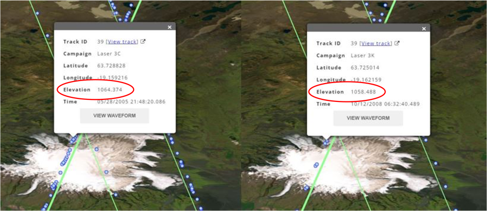
Beyond offering users different workflows based on their individual needs, OA also makes it easy for users to compare surface elevations over time without having to download or manipulate any data.

"One interesting demonstration of this is to look at Lake Powell in Colorado," said Beig. "We're really interested in water resources here in Colorado, and with OA you can look at a transect across Lake Powell from five years ago and then for this year, and you can quickly and easily get a measurement of the change in water level over time."

OA image of a lake acquired on different years with a red circle around elevation to highlight decrease in elevation over time
Image Caption

These comparison images of OpenAltimetry ICESat data show the change in elevation over a data acquisition point in Iceland on May 28, 2005, (left) and October 12, 2008 (right). Credit: OpenAltimetry/NASA's NSIDC DAAC.

Should users wish to download the data they’ve visualized, OA gives users the option of downloading ICESat or ICESat-2 data in Hierarchical Data Format Version 5 (HDF5) and comma separated value (CSV) file formats. Users can get an Application Programming Interface (API) for the data they've selected to use in a Jupyter Notebook or another tool.

Taken together, these features have made OA a popular data discovery and visualization tool with hundreds of thousands of users each year.

"Moving OA into NASA's Earthdata Cloud environment and having the NSIDC DAAC take over its maintenance is a real testament to this tool's success," said Beig. "It started with an ACCESS grant, which helped the project get off the ground. The developers then built this wonderful application and the user community embraced it and now value it very highly. It's because of that success that [NASA's Earth Science Data Systems Program] is excited to take over the long-term maintenance of this tool."

Located in Boulder, Colorado, NASA's NSIDC DAAC provides data and information for snow and ice processes, particularly interactions among snow, ice, atmosphere, and ocean, in support of research into global change detection and model validation. The DAAC archives and distributes cryosphere and climate-related products from several EOS sensors and provides general data and information services to the cryospheric and polar processes research community.

Accessing OpenAltimetry

Users can access OpenAltimetry via the Earthdata Cloud as well as through the Data Tools page.

Resources

Details

Last Updated

Published

Data Center/Project

National Snow and Ice Data Center DAAC (NSIDC DAAC)