Dr. Pinki Mondal, Senior Research Associate, Center for International Earth Science Information Network (CIESIN), Columbia University, Palisades, NY (Note: Starting in August 2018 Mondal will be an Assistant Professor, Department of Geography, University of Delaware, Newark, DE)
Research interests: Human-environment interactions with a specific focus on the sustainability of agricultural ecosystems, agricultural sensitivity to climate variability, adaptation strategies for smallholder farms, and the effects of national-level policies on forestry and conservation.
Research highlights: Counting the residents of the second most populous nation in the world is a daunting task, but one India has undertaken every 10 years since the late 1800s (as a British colony until 1947, then as an independent nation). The numbers from the 2011 Indian census reveal that almost 70% of the nation’s more than 1.2 billion inhabitants live in rural areas, with a majority of these rural residents engaged in agriculture.
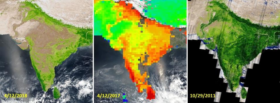
While the Census of India collects data at ground level showing where the population lives, instruments aboard Earth observing satellites constantly collect data showing how land is used. These remotely-sensed data are a foundation of Dr. Pinki Mondal’s studies into the sustainability of agricultural systems and the impacts of climate variability on agriculture in South Asia. Mondal currently conducts her research at CIESIN, which is the location of NASA’s Socioeconomic Data and Applications Center (SEDAC). SEDAC is an Earth Observing System Data and Information System (EOSDIS) Distributed Active Archive Center (DAAC), and supports the integration of socioeconomic and Earth science data in order to serve as an information gateway between the Earth sciences and social sciences.
Satellite data can reveal a lot about the socioeconomic impacts of urbanization and environmental change, and help researchers more easily identify changes in landscape patterns across a wide range of spatial (local, regional, or continental) and temporal (week, month, or year) scales. For example, nighttime lights imagery from the Visible Infrared Imaging Radiometer Suite (VIIRS) make it easy to see the spread of urbanization into previously rural areas through changes in the density of human-added lights. Vegetation indices created from data collected by the Moderate Resolution Imaging Spectroradiometer (MODIS) aboard the Terra and Aqua satellites and by instruments aboard the joint NASA/U.S. Geological Survey’s (USGS) Landsat series of satellites enable researchers to more easily analyze changes in vegetation and spot patterns across entire continents. As Mondal notes, her research would be impossible without NASA Earth science data.

