NASA-Funded Project Uses AI to Map Maui Fires from Space

The project, described as a “breakthrough for fire mapping from space,” is producing high resolution maps to help guide post-fire recovery and remediation efforts.
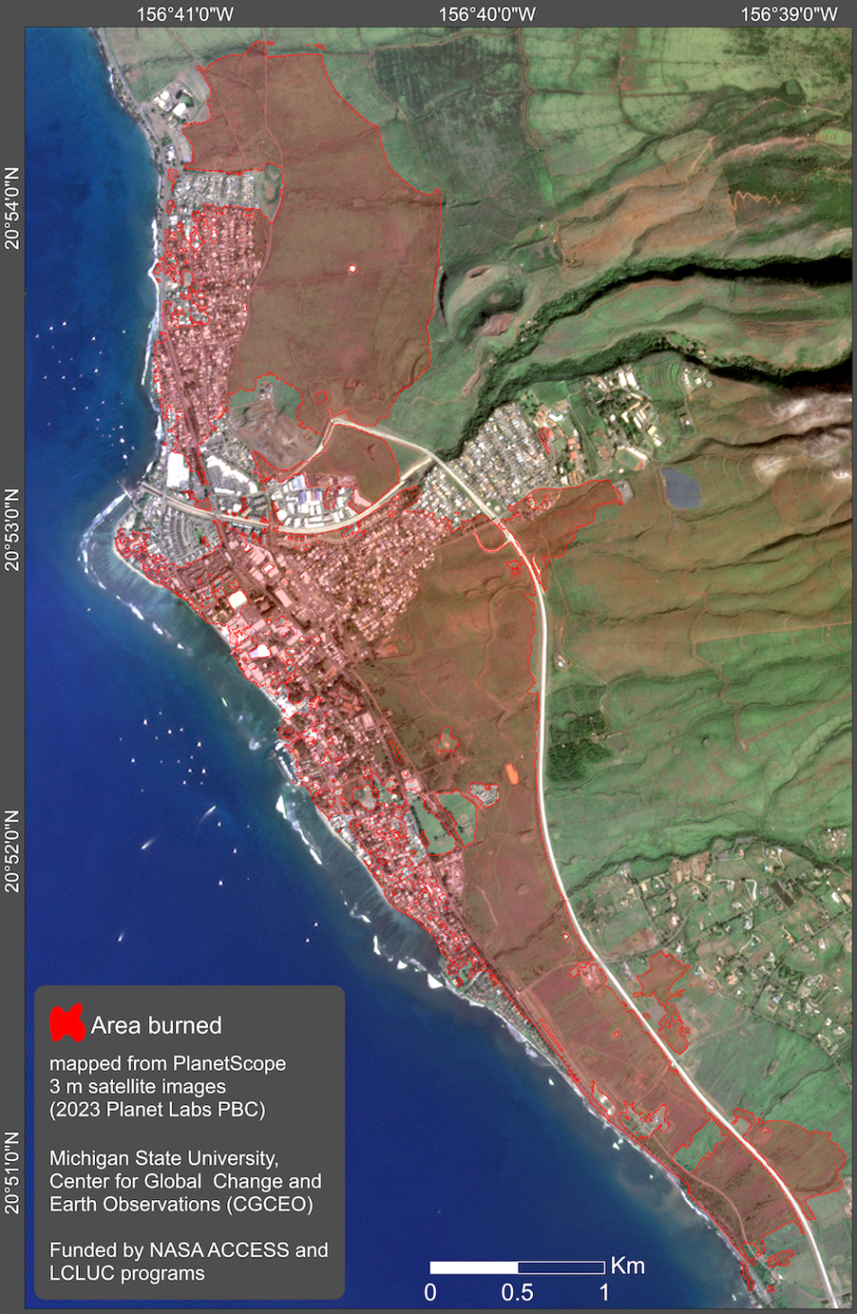
Image
Map produced by the ACCESS/LCLUC project team using AI applied to a PlanetScope satellite image to show burned areas in and around Lahaina, Maui, Hawaii. Credit: MSU CGCEO.

Recovery efforts from the devastating fires that swept through Maui and other Hawaiian islands in August are benefitting from a project funded through NASA’s Advancing Collaborative Connections for Earth System Science (ACCESS) and Land Cover and Land Use Change (LCLUC) programs. 

Described as a “breakthrough for fire mapping from space,” the Michigan State University (MSU)-led project uses artificial intelligence (AI) and high-resolution commercial satellite imagery from Planet Labs PBC to produce maps of burned areas in higher detail than ever before. These maps enable scientists, managers, and local governments to better assess post-fire impacts, study burned areas, and help plan mitigation efforts.

“There is an urgent need for timely detailed maps of burned areas as climate warming and drier conditions have led to longer and more active fire seasons,” says Dr. David Roy, project Principal Investigator (PI) and director of MSU’s Center for Global Change and Earth Observations (CGCEO).

Applying a new AI algorithm to Planet imagery acquired between August 3 and 13, 2023, the project team created three-meter resolution maps of Maui's burned areas. This resolution is significantly greater than NASA’s existing burned area products, which are created from data acquired by the Moderate Resolution Imaging Spectroradiometer (MODIS; MCD64A1) and Visible Infrared Imaging Radiometer Suite (VIIRS; VNP64A1) instruments and have a 500-meter resolution. Developing improved algorithms to produce higher resolution burned area maps is a key objective of the NASA-funded work.

“Access to near daily three-meter PlanetScope imagery globally combined with rapid advancements in AI offer exciting opportunities to map smaller burned areas that coarser resolution satellite products usually miss,” says Roy.

The project team notes that by combining satellite detections of actively burning fires—which are available globally in near real-time through NASA’s Fire Information for Resource Management System (FIRMS)—with their high-resolution maps, enables patterns of fire spread and impacts to be readily assessed.
Image
Incorporating VIIRS active fire detection data on the fire map provides valuable information about fire development and movement on the island of Maui between August 8-10, 2023. Colored circles on the map indicate specific days on which fires were detected; red areas near and around the circles indicate burned areas. Credit: MSU CGCEO.

The overall MSU project objective is to develop a collection of training data for large area land cover classification and disturbance mapping and validation through the application of AI to commercially available high-spatial resolution (<10-meter) satellite data. The three-meter resolution imagery created for the Maui recovery efforts is a practical application of this work. In keeping with NASA open science policies, algorithms and software developed through the work will be available in open-source code repositories.

The project team is also using NASA LCLUC funding to improve understanding of global fire activity. There is a long-held but untested view that globally the majority of burned area is due to very large fires; while this may be true in certain boreal systems, the role of small fires is currently not reliably known. 

ACCESS develops and implements technologies to effectively manage, discover, and utilize NASA's archive of Earth observations for scientific research and applications, and is overseen by NASA's Earth Science Data Systems (ESDS) Program. LCLUC is an interdisciplinary science program in NASA’s Earth Science Division that seeks to develop the capability for periodic global inventories of land use and land cover from space, enhance the scientific understanding and models necessary to simulate the processes taking place, and evaluate the consequences of observed and predicted changes. Funding opportunities for both programs are solicited competitively through NASA's Research Opportunities in Space and Earth Science (ROSES).