Every second, lasers on the International Space Station send 242 rapid pulses of light down to Earth. These harmless beams from NASA’s Global Ecosystem Dynamics Investigation (GEDI) instrument bounce off Earth’s natural and human-made surfaces and are reflected back to the instrument. By measuring the time it takes for the signals to come back, scientists can derive the height of the surface below.
Scientists use these light detection and ranging, or lidar, measurements to create 3D profiles of Earth's surface. GEDI’s primary mission is to measure tree heights and forest structure in order to estimate the amount of carbon stored in forests and mangroves. New research supported by NASA Harvest reveals these data also can be used to map where different types of crops are being grown.
When David Lobell, an agricultural ecologist at Stanford University, saw research using GEDI data to estimate tree heights, he wondered how he could use the data to study agriculture. Stefania Di Tommaso and Sherrie Wang, researchers on his team, came up with the idea of using the data to distinguish different types of crops growing on farms.
Wang reached out to the GEDI science team at the University of Maryland to see if they were using GEDI for agricultural research. They responded that they were not sure that GEDI data could be used for such an application. “But they didn’t say it was impossible,” said Lobell.
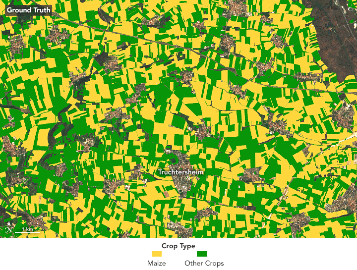
Mapping where certain crops are grown is important for estimating the production of the world’s major crops. But it has been difficult to reliably map crop types from space because many look the same in optical imagery.
Lobell and his team started with corn (maize). When fully grown, average corn stalks are about a meter taller than other crops—a difference that is detectable in GEDI profiles. Using this insight, the Stanford team combined the lidar profile data from GEDI with optical imagery from the European Space Agency’s Sentinel-2 satellites. They were able to remotely map corn in three regions where there is good ground-based data to validate their observations: the state of Iowa in the U.S., the province of Jilin in China, and the region of Grand Est in France.