Delivery of new Suomi NPP data ceases on Nov. 2, 2026. Users should transition to alternative products.
Suomi NPP data announcement
High Aerosol Index over USA
Image captured on 13 September 2020, by the OMPS instrument, aboard the joint NASA/NOAA Suomi NPP satellite.
Image
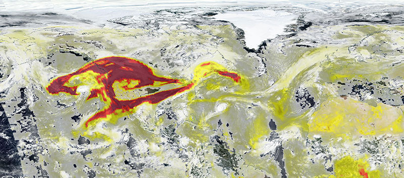
Image of high aerosol index over USA, as a result of fires in the western US, acquired on 13 September 2020. The Aerosol Index layer from the Ozone Mapping Profiler Suite (OMPS) aboard the joint NASA/NOAA Suomi National Polar orbiting Partnership (Suomi NPP) satellite, is overlaid on top of the true-color image. The Aerosol Index is a unitless range from < 0.00 to >=5.00, shown as yellows to reds, where 5.0 (reds) indicates heavy concentrations of aerosols that could reduce visibility or impact human health.
The photo-like, true-color corrected reflectance image was captured by the Visible Infrared Imaging Radiometer Suite (VIIRS), also aboard Suomi NPP satellite.
Visit Worldview to visualize near real-time imagery from NASA's EOSDIS, and check out more Worldview weekly images in our archive.
Details
Last Updated
Published on
Nov. 4, 2020