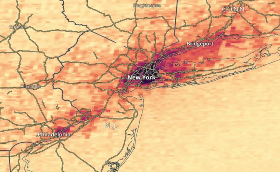
The TEMPO instrument is an ultraviolet and visible spectrometer that launched on April 7, 2023, aboard the Intelsat 40e satellite. TEMPO is on the Earth-facing side of the satellite, which is in a geostationary orbit 22,000 miles above Earth's equator at 91°W longitude. This allows the instrument to maintain a constant view of North America so that its light-collecting mirror can make a complete east to west scan of its field of regard (FOR)—from the Atlantic to the Pacific, and from the Yucatan Peninsula to the Canadian oil sands—during daylight hours. By measuring sunlight reflected and scattered from Earth's surface and atmosphere back to the instrument's detectors, TEMPO's ultraviolet (UV) and visible light sensors collect data related to ozone (O3), nitrogen dioxide (NO2), formaldehyde (HCHO), and other elements of daily atmospheric chemistry cycles.
Level 2 TEMPO imagery is available in NASA Worldview as approximately six-minute granules for daylight hours over North America. Each granule covers the entire North-South TEMPO FOR but only a portion of the East-West FOR. The temporal resolution is approximately one hour during daylight hours, with more frequent scans in the morning over the eastern portion of the FOR and in the evenings over the western portion of the FOR. The sensor's spatial resolution is ~2 km x 4.75 km at the center of TEMPO's FOR, and the imagery resolution is 1 km.
Level 3 files are derived by combining information from all Level 2 files constituting a TEMPO East-West scan cycle, using an area-weighted re-gridding approach. Level 3 TEMPO imagery is available in NASA Worldview as approximately one-hour scans for daylight hours over North America on a regular grid. The Level 3 product resolution is 0.02 x 0.02 degrees and the imagery resolution is 2 km.
New TEMPO Worldview Data Layers
Cloud Fraction
One Level 2 and one Level 3 cloud fraction total layer are available. Both provide information on the effective cloud fraction at 466 nm derived from the O2-O2 cloud retrieval algorithm and are unitless quantities. The layers are filtered to display high-quality pixels with solar zenith angles less than 80 degrees.
Cloud Pressure
One Level 2 and one Level 3 cloud pressure layer are available. Both provide information on the optical centroid pressure of clouds derived using the O2-O2 cloud retrieval algorithm and are measured in hectopascals (hPa). The layers are filtered to display high-quality pixels with solar zenith angles less than 80 degrees.
Formaldehyde
One Level 2 and one Level 3 layer are available. Both layers provide information on the total amount of formaldehyde in a vertical column of the atmosphere. The layers are filtered to display high-quality pixels using the main data quality flag, solar zenith angle, and effective cloud fraction variables.
The TEMPO formaldehyde products provide information on the total amount of formaldehyde in a vertical column of the atmosphere. This is provided as the total number of formaldehyde molecules in a column of air above one square centimeter on Earth’s surface (molecules/cm2).
Nitrogen Dioxide
Two Level 2 and two Level 3 layers are available. The Level 2 layers provide NO2 information at TEMPO's native spatial resolution for individual granules, while the Level 3 layers provide NO2 information on a regular grid. All four layers are filtered to display high-quality pixels using the main data quality flag and solar zenith angle variables.
The TEMPO nitrogen dioxide products provide information on the amount of nitrogen dioxide in the stratosphere and troposphere. This is provided as the total number of nitrogen dioxide molecules in the stratospheric and tropospheric column of air above one square centimeter on Earth’s surface (molecules/cm2).
Ozone Cloud Fraction
One Level 2 and one Level 3 layer are available. The Level 2 layer provides ozone and supporting information at TEMPO’s native spatial resolution for individual granules, while the Level 3 layer provides ozone and supporting information on a regular grid. Both layers are filtered to display high-quality pixels with solar zenith angles less than 80 degrees.
The TEMPO ozone cloud fraction products provide information on the effective cloud fraction (a unitless quantity) derived using the mixed Lambert Equivalent Reflectivity (LER) model from the total ozone retrieval algorithm. The retrieval is based on the Ozone Monitoring Instrument Total Ozone Mapping Spectrometer (OMI TOMS) V8.5 algorithm adapted for TEMPO.
Ozone Column Amount
One Level 2 and one Level 3 layer are available. The Level 2 layer provides ozone and supporting information at TEMPO’s native spatial resolution for individual granules, while the Level 3 layer provides ozone and supporting information on a regular grid. Both layers are filtered to display high-quality pixels with solar zenith angles less than 80 degrees.
The TEMPO ozone column amount products provide information on the total amount of ozone in a vertical column of the atmosphere, which is measured in Dobson Units (DU). The retrieval is based on the OMI TOMS V8.5 algorithm adapted for TEMPO.
Adding Data Imagery Layers
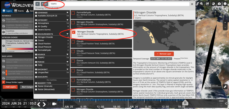
To add TEMPO data layers to the Worldview base map, click the orange Add Layers button at the bottom of the layer list, circled in the image below.

