New products for determining atmospheric aerosol loading for daytime cloud-free, snow-free scenes and for determining confidence in cloud-free views of Earth are the two newest near real-time (NRT) products available in NASA’s Land, Atmosphere Near real-time Capability for EOS (LANCE). Both products are produced using data acquired by the Visible Infrared Imaging Radiometer Suite (VIIRS) aboard the joint NASA/NOAA Suomi National Polar-orbiting Partnership (Suomi NPP) satellite and are available generally within three hours of a satellite observation.
New VIIRS Atmosphere Imagery Products in LANCE
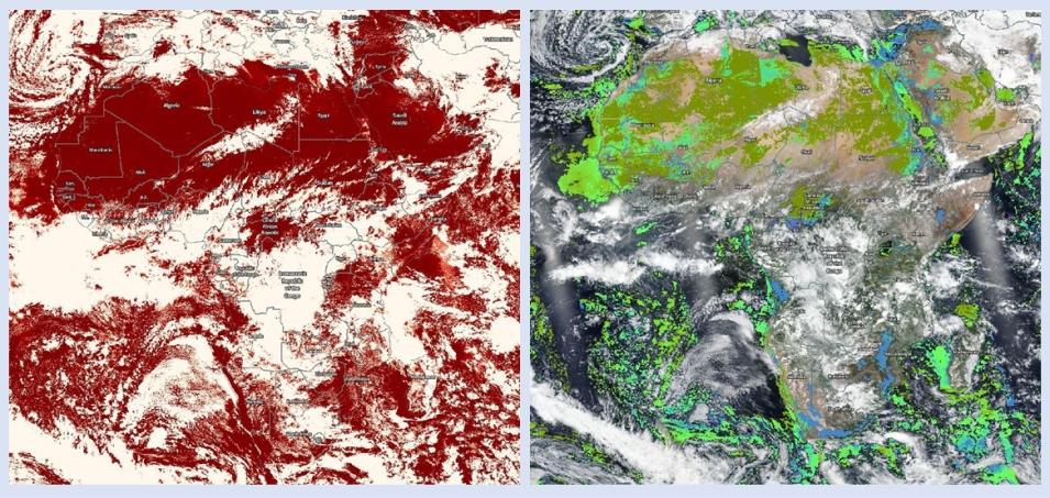
NASA Worldview examples of the two new VIIRS Atmosphere products over Africa on March 22, 2020. Both products are shown on a Suomi NPP daily global base map image. Left image shows the Cloud Mask, with white indicating clouds and dark red indicating high probability of clear sky (easily seen over the Sahara Desert near the top of the image). Right image shows the Deep Blue Aerosol Product, with colors indicating Aerosol Angstrom Exponent. The Angstrom Exponent is a measure of the wavelength-dependence of aerosol optical depth (AOD), which is related to aerosol particle size. Interactively explore both images using NASA Worldview: https://go.nasa.gov/2UwxSbs (Cloud Mask); https://go.nasa.gov/2wQuiQ9 (Deep Blue).
The VIIRS Level 2 Deep Blue Aerosol Product (short name: AERDB_L2_VIIRS_SNPP_NRT) uses the Deep Blue (DB) algorithm over land and the Satellite Ocean Aerosol Retrieval (SOAR) algorithm over water to determine atmospheric aerosol loading. The product is designed to facilitate continuity in the aerosol record provided by the Deep Blue Multi-Sensor Aerosol Project for other sensors, including the Sea-viewing Wide Field-of-view Sensor (SeaWiFS, operational 1997 to 2010) and by the Moderate Resolution Imaging Spectroradiometer (MODIS) instruments aboard NASA’s Terra and Aqua Earth observing satellites. Deep Blue uses measurements from multiple Earth observing satellites to determine the concentration of atmospheric aerosols along with the properties of these aerosols.
The VIIRS Cloud Mask (short name: CLDMSK_L2_VIIRS_SNPP) is a Level 2 product created using a series of visible and infrared threshold and consistency tests to assess cloud cover and assess confidence that an unobstructed view of Earth’s surface is being observed. The VIIRS Cloud Mask product is derived from the MODIS-VIIRS cloud mask (MVCM) algorithm, which is based on the MODIS MOD35 (Cloud Mask) algorithm. This ensures continuity between the MODIS and VIIRS Cloud Mask products.
Both LANCE products consist of different parameters that can be interactively explored using the NASA Worldview data visualization application. Two parameters from the LANCE Deep Blue Aerosol Product (Aerosol Exponent and Aerosol Optical Thickness) are available as imagery layers in Worldview. For the LANCE VIIRS Cloud Mask Product, Worldview displays the Day and Night imagery layers of the Clear Sky Confidence parameter.
The products were developed by NASA’s VIIRS Atmosphere Science Investigator-led Processing System (Atmosphere SIPS), which is located at the Space Science and Engineering Center (SSEC) at the University of Wisconsin-Madison. The VIIRS Atmosphere SIPS is responsible for processing, reprocessing, and general assessments of Suomi NPP VIIRS Atmosphere products.
Explore these new VIIRS Atmosphere NRT products in LANCE
Learn more about these VIIRS Atmosphere NRT products:
VIIRS Level 2 Deep Blue Aerosol doi: 10.5067/VIIRS/AERDB_L2_VIIRS_SNPP_NRT.001
VIIRS Cloud Mask Level 2 doi: 10.5067/VIIRS/CLDMSK_L2_VIIRS_SNPP_NRT.001
