A Spread of Green

People and heat spread north into Arctic permafrost.

The snowy reaches of Siberia sprawl across northern Russia, spanning three-quarters of the country. Dense forests of coniferous trees rise from the cold and swampy terrain of sub-Arctic taiga. Further north, the towering woodlands give way to Arctic tundra: frigid open country encrusted with moss and lichen. Dominated by these two biomes, Siberia remained sparsely populated for centuries. By the 20th century, however, rich reserves of oil and minerals were discovered, and Russians eagerly streamed north to fill jobs. The flood of people and industry changed Siberia’s fate, turning quiet settlements first into boomtowns, then into bustling cities.

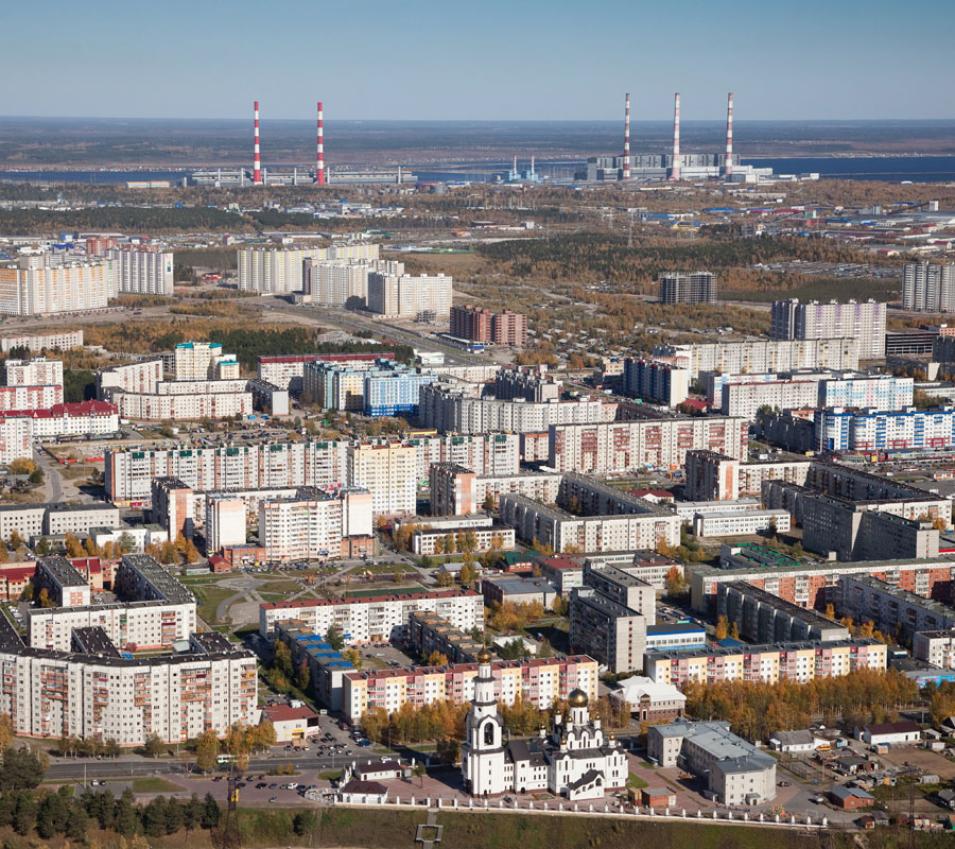
When oil was discovered in northern West Siberia, Russia wasted no time developing the new oil fields. The small fishing settlement of Surgut was one of the remote outposts dotting the region. Located on the banks of the Ob River, Surgut’s population surged, and it was granted town status in 1965. By 2015 Surgut had become the unofficial oil capital of the country, home to 340,000 people. Modern Surgut now offers theaters and shopping malls, tree-lined streets and parks. And like Russia’s other booming cities, Surgut leaves a growing footprint on its environment.

Igor Esau and Victoria Miles, researchers at the Nansen Environmental and Remote Sensing Center in Norway, saw the oil and gas boom as an opportunity to study these footprints. They and their colleagues looked at 28 cities and towns across northern West Siberia as well as at the surrounding natural landscapes. How did urban development affect Arctic vegetation over time? And how might accelerated Arctic warming amplify these changes?
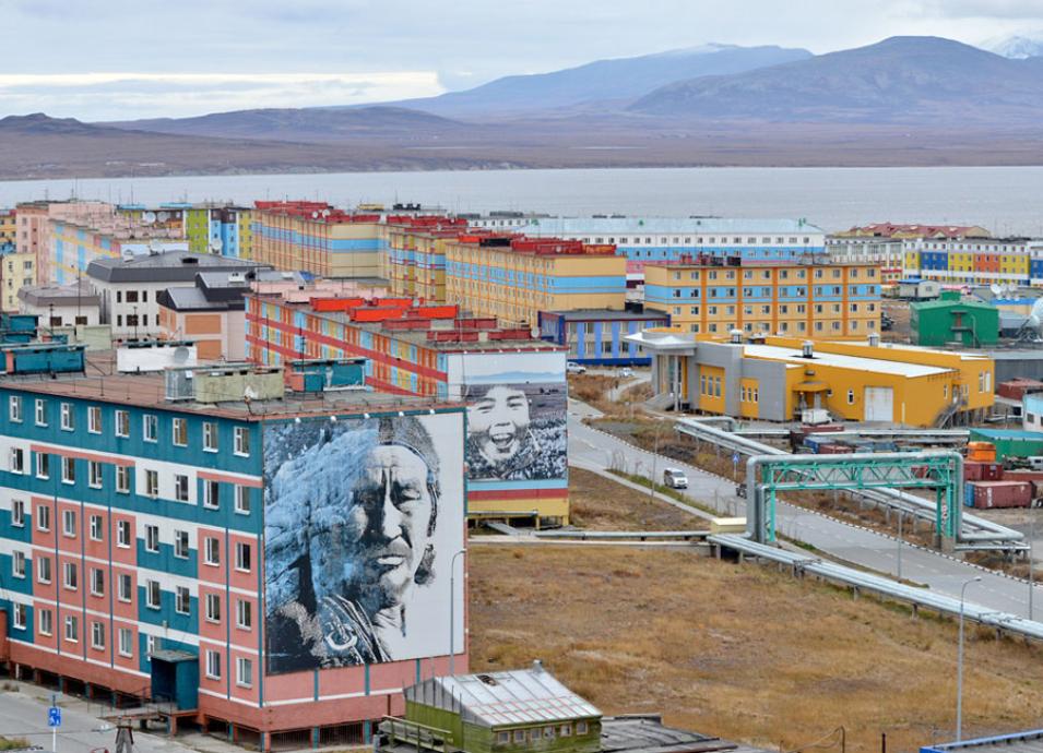
Photograph of buildings on piles in Anadyr, Russia
Image Caption

These buildings in Anadyr, Russia, are built on foundation piles to prevent heat from thawing the frozen ground below. (Courtesy US Consulate Vladivostok)

Biomes of green and brown

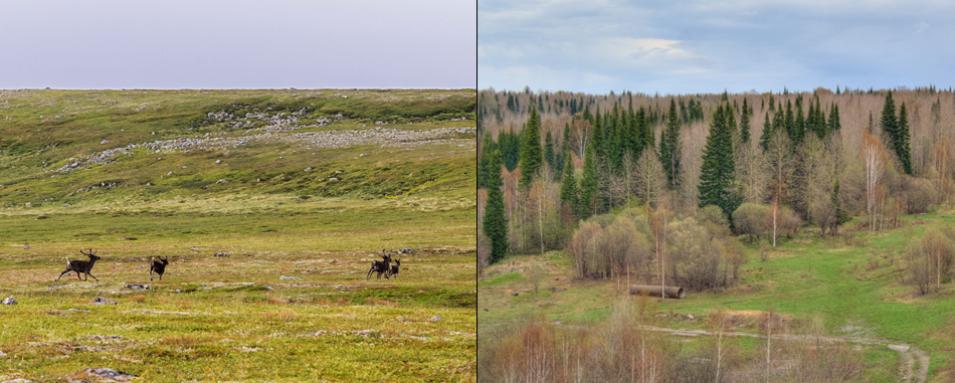
The key to understanding how cities impact taiga and tundra landscapes is permafrost, permanently frozen ground. In the northernmost stretches of Siberian tundra, permafrost is continuous, meaning most of the region’s ground remains frozen. Arctic tundra is usually treeless, populated by low-lying vegetation that can survive the gelid habitat and short growing seasons. In contrast, the discontinuous permafrost found across southern Siberia exists only in portions or in sporadic areas, making the region more hospitable to swampy taiga forests.

Overlying many permafrost areas is a thin active layer that thaws seasonally, allowing plants and trees to grow. Larch trees thrive in permafrost regions because their root systems are broad instead of deep, thus remaining in the active layer. Whether continuous or discontinuous, permafrost requires low temperatures to remain stable, and anything built atop it—roads, pipelines, or cities—can disturb this stability.

As cities grow, natural vegetation is replaced by clusters of roads and buildings. Man-made landscapes of impervious surfaces and drier urban soils tend to absorb heat, meaning many cities become urban heat islands that are warmer than surrounding areas. In temperate climates, urban heat islands warm the air, making sweltering summer heat even more oppressive. In the Arctic, heat islands also warm the soil, which may thaw the underlying permafrost and have far-reaching effects on tundra and taiga landscapes. Modern Surgut, for instance, is only 50 years old, but is already warming. “Surgut is now about 10 degrees Celsius [18 degrees Fahrenheit] above normal, which means that ecosystems around the city have a climate that could otherwise only be found 600 kilometers [373 miles] to the south,” Esau said. Even small settlements and industrial areas are 1 to 2 degrees Celsius (2 to 4 degrees Fahrenheit) warmer, particularly during long polar summer days.

Researchers needed vegetation data to map the heat island effect relative to the surrounding Arctic environments. Because meteorological stations are sparse at such high latitudes, the researchers relied on the Moderate Resolution Imaging Spectroradiometer (MODIS) instrument flying on the NASA Terra satellite. MODIS data from 2000 to 2014 offered a detailed view of greenness, or vegetation health, across Siberia. Changes in greenness provide a proxy for each city’s footprint. To measure this footprint, the researchers included a 40-kilometer (25-mile) ring around each city, broken into concentric, 5-kilometer (3-mile) rings centered around the city core.

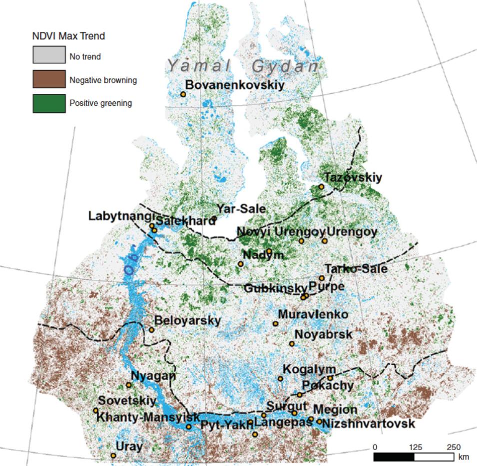
Over the 15-year period, the data showed a trend of warmth creeping north. Taiga in the southern portions of West Siberia warmed, causing trees to die and turn brown. By contrast, the northern tundra became greener. Shrubs and grasses filtered in, and even larch trees were popping up in the typically treeless tundra. Siberian larch, a staple of taiga forests, require long cold winters, so a northward shift heralded broader change. Miles said, “This sparse larch forest now occupies a big area on the North Siberian Plain, on the border between the tundra and the boreal forest.”

Photographs (left) of reindeer on Arctic tundra and (right) taiga forests in sub-Arctic Russia
Image Caption

Reindeer scamper across the treeless Arctic tundra, left. Swampy forests, or taiga, are common across sub-Arctic Russia, right. (Courtesy V. Sagaydashin, left, and I. I. Savin, right)

Booming and blooming

Amid these sweeping shifts, Esau and his colleagues discovered that all of the cities and their surrounding 40-kilometer rings had become greener. “We were really puzzled about this development. It was unexpected,” Esau said. The older and more established a city was, the greener it appeared over the 15-year record. Northern tundra and northern cities alike were greening. And greening cities like Surgut, located in the taiga, stood out amid swaths of brown.

The construction boom included not just buildings, but pleasant and environmentally welcoming spaces, such as parks and tree-lined streets. “This increased greenness of the cities was very much because of change in the attitude toward the environment,” Esau said. “Now practically every city in this region implements one or another kind of green space development program.”

Residents use these parks and green spaces year-round, according to Natasha Rubanova, who grew up in Surgut, though she now lives in Massachusetts. “There is roller skating, jogging, cycling, walking dogs, taking kids to playgrounds. Some people even sun bathe,” she said. Throughout the short summers, the city also uses parks for festivals and celebrations.

Similar to other cities elsewhere around the world, people in Siberia are shaping their own environment, carving a human habitat and sense of home out of an otherwise harsh landscape. But the heat island effect does not stop at city limits. Changes in vegetation slowly bleed outward, leaving a larger stamp on the landscape. While increasing greenness itself did not cause the heat island effect, it pinpointed where dramatic changes were happening. The real cause of the Arctic’s urban heat islands lay a bit deeper: the permafrost they were built on.

Aerial photograph of Surgut, Russia
Image Caption

After a massive oil and gas development boom in northern West Siberia, Surgut has grown to become the oil capital of Russia. (Courtesy V. Melnikov, Shutterstock)

Extracting an ecosystem

Construction on Arctic permafrost poses unique problems because the active layer’s freeze-thaw cycle creates an unstable surface. “To build something there, you need to create some higher ground, otherwise, it’s always boggy and muddy there,” Esau said. So developers extract sand and gravel from river beds to create a base layer. Then, foundation piles are driven into the permafrost, sometimes more than 15 meters (49 feet) deep, which bear the weight of the building. Buildings are then perched atop the stilt-like piles, insulating frozen ground from heat generated in the buildings.

“But sand has a different thermal property than the normal soil found in this area,” Esau said. Unlike permafrost, which is impermeable, sand allows water to drain through. Sandy surfaces are drier and warmer than the frozen ground beneath, and contribute to the urban heat island effect. “This effect is larger than the city itself, because sandy and artificial surfaces destroy natural vegetation patches,” Esau said. “The effects proliferate around an area larger than the buildings themselves.”

As the researchers zoomed out from the city center, they saw shifts to what Esau calls alternative ecosystems. Shrubs and grasses were infiltrating the low-lying tundra, but in taiga forests, dying native vegetation was not always replaced by other species moving in. Thawing permafrost leaves behind a water-logged environment that not many plants are adapted to survive in. “More than 30 percent of the territory is bogs, swamps, mires,” Esau said.

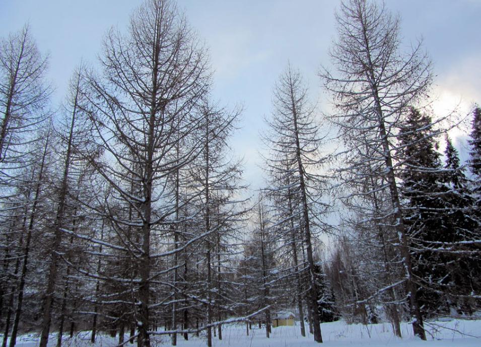
Photograph of Siberian larch trees
Image Caption

Siberian larch are deciduous conifers, dropping their needles each winter. Larch forests are spreading further north into the Siberian tundra. (Courtesy A. Salo)

Islands in a regime

Even as the effects of urban heat islands radiate to the surrounding environment, cities themselves feel the effects. In a few Arctic cities, some foundations are cracking and buildings are crumbling, ultimately forcing residents to move. But rising temperatures are not entirely to blame, according to Nikolay Shiklomanov, a professor at George Washington University who studies Arctic climate change and urban infrastructure. Each city is a complex system, making it difficult to predict how buildings, roads, and utilities collectively impact the sensitive thermal regime of permafrost. “That’s really difficult to model or test at the scale of the city,” he said. “When you sprinkle people on top of that, their activities make interactions between an urban system and permafrost much more complex. For example, plowing roads can mess with the ground temperature field.”

In addition, construction on permafrost tends to have a shorter life span, and Russia’s Arctic settlements grapple with aging infrastructure and lack of maintenance, often a result of the economic malaise following the 1991 dissolution of the Soviet Union. “While climate-induced permafrost changes have some impact, a good deal of these deformations were probably initiated by human factors,” Shiklomanov said. For instance, leaking pipes or even substandard construction can promote permafrost thaw. “During the Soviet time, there were strict standards of permafrost construction,” Shiklomanov said. “Now standards largely are up to individual builders.”

Shiklomanov looked at data stretching back through the 20th century, isolating Arctic climate changes across Siberia. He and his colleagues then looked into the future, compiling results from six different climate models to analyze the weight-bearing capacity of the cities’ pile foundations. As temperatures increase, the bearing capacity of piles decreases significantly because they were designed for certain temperatures and can be negatively affected by warming. By 2050, buildings in many Siberian cities may begin to crumble or fall apart as the underlying permafrost degrades and piles give way.

Evidence indicates the Arctic will only continue to warm. “As climate change progresses, it will play a bigger role,” Shiklomanov said. “So right now, while it’s not the primary reason for deterioration of urban infrastructure, it definitely made things worse. As warming progresses, it has the potential to become a prime reason for decreased stability of structures on permafrost.” This means rising temperatures can potentially impact many of the 40 million people who consider Siberia home. Will engineers and urban planners innovate ways to mitigate the heat island effect in the Arctic? Or will they adapt construction methods to accommodate a thawing environment? Siberia’s fate has changed in the past, and its future is not set in stone—or permafrost.

Map illustrating vegetation trends across West Siberia
Image Caption

This map shows trends in vegetation (Normalized Difference Vegetation Index, NDVI) in West Siberia between 2000 and 2014. Greens indicate increasing greening; browns indicate browning. The southern portion of northern West Siberia browned as forested taiga biomes became stressed by rising temperatures. The northern portion warmed and greened, with small shrubs, grasses, and even larch trees spreading north into the tundra. Data are from the Moderate Resolution Imaging Spectroradiometer (MODIS) instrument on the NASA Terra satellite. (Courtesy I. Esau, et al., 2016, Atmospheric Chemistry and Physics)

References

Esau, I., V. V. Miles, R. Davy, M. W. Miles, and A. Kurchatova. 2016. Trends in normalized difference vegetation index (NDVI) associated with urban development in northern West Siberia. Atmospheric Chemistry and Physics 16: 9,563–9,577. doi:10.5194/acp-16-9563-2016.

Miles, V. and I. Esau. 2016. Spatial heterogeneity of greening and browning between and within bioclimatic zones in northern West Siberia. Environmental Research Letters 11, 115002. doi:10.1088/1748-9326/11/11/115002.

NASA LP DAAC. 2016. MOD13Q1 MODIS Vegetation Indices 16-Day L3 Global 250m. NASA EOSDIS Land Processes DAAC, USGS Earth Resources Observation and Science (EROS) Center, Sioux Falls, SD (https://lpdaac.usgs.gov), at https://lpdaac.usgs.gov/dataset_discovery/modis/modis_products_table/mod13q1.

Shiklomanov, N. I. and D. A. Streletskiy. 2013. Effect of climate change on Siberian infrastructure. In Regional environmental changes in Siberia and their global consequences, eds. P. Ya. Groisman and G. Gutman. Netherlands: Springer. doi:10.1007/978-94-007-4569-8_5.

Shiklomanov, N. I., D. A. Streletskiy, T. B. Swales, and V. A. Kokorev. 2016. Climate change and stability of urban infrastructure in Russian permafrost regions: prognostic assessment based on GCM climate projections. Geographical Review 107(1): 125–142. doi:10.1111/gere.12214.

For more information

NASA Land Processes Distributed Active Archive Center (LP DAAC)

NASA Moderate Resolution Imaging Spectroradiometer (MODIS)

Anthropogenic Heat Islands in the Arctic (HIARC)

About the remote sensing data
Satellite Terra
Sensor Moderate Resolution Imaging Spectroradiometer (MODIS)
Data set Vegetation Indices 16-Day L3 Global 250m (MOD13Q1)
Resolution 250 meter
Parameter Normalized Difference Vegetation Index (NDVI)
DAAC NASA Land Processes Distributed Active Archive Center (LP DAAC)

Details

Last Updated

Published

Data Center/Project

Land Processes DAAC (LP DAAC)