New Worldview Features make it Easier to Explore All of Fiji (and the Rest of the World)

New features in Worldview 1.4.0 (along with new imagery to view using Worldview) allow you to more easily and completely explore the planet using NASA Earth science data.

The latest update to NASA’s Worldview data visualization application brings a wealth of new features—including the ability to finally see the island nation of Fiji in its entirety. Enhancements include a continuous view of the Pacific Ocean across the International Date Line (which requires data from two different days), quick data value indications, and enhancements to the Events feed. Along with the added features, the availability of almost 20 new data sets to explore help make Worldview more useful than ever before.

Prior to this update, Fiji and other locations sitting along the 180th meridian could not be viewed completely using data from a single day since the 180th meridian (also called the anti-meridian) is the approximate location of the International Date Line. Worldview now allows data users to view a seamless Pacific Ocean by matching data collected over two consecutive days on either side of the 180th meridian.

Worldview dateline image
Image Caption

The image to the right of the dashed line in the middle of this Worldview image is from 8 April 2017; the image to the left of the line is from 9 April 2017. The more than 300 islands comprising Fiji extend across these combined images in the South Pacific Ocean. NASA Worldview image.

Image showing AOD value from data overlay
Image Caption

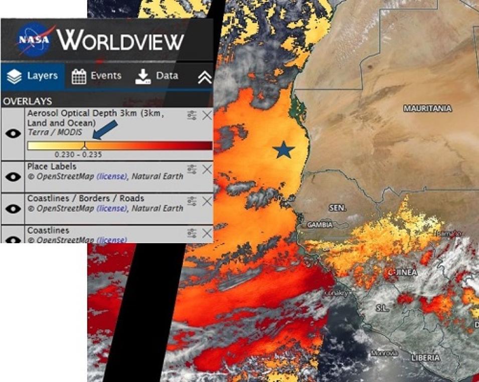
Terra/MODIS Aerosol Optical Depth (AOD) off the western coast of Africa for 6 April 2017. Hovering over the spot indicated by the star automatically shows that the AOD in this area is between 0.230 and 0.235 (blue arrow). NASA Worldview image.

Along with the ability to view a seamless Earth, Worldview users now can easily determine values indicated by color keys associated with a data layer. Simply place a cursor over a colored location on the Worldview map and the value represented by that color is indicated on the associated color key on the left side layer panel. This feature makes it easy to determine data values at a glance and rapidly assess conditions in an area.

The third major enhancement to Worldview are two additions to the Events feature. More than a dozen icons now differentiate events into event categories, such as weather, landslides, temperatures, and flooding, making it easy to quickly distinguish between types of events. Once an event is selected, new bold markers and bounding boxes highlight the specific location of the event.

Worldview Event marker
Image Caption

The addition of markers (shown) and bounding boxes to Worldview Events make it easy to pinpoint an event location. NASA Worldview image.

A final enhancement to Worldview in this new release is something data users won’t see—the addition of an auto-disable function that prevents a data layer from being turned on if imagery is not available for a selected date. This helps eliminate confusion when layers for a selected date seemingly do not load.

Worldview Event tab icons
Image Caption

New Worldview Event icons were developed by open source contributor CodeMacabre and appear next to event names.

Along with all the new features, Worldview also has more imagery to view. Among the almost 20 new data products available for viewing using Worldview are:

  • Daily Moderate Resolution Imaging Spectroradiometer (MODIS) Normalized Snow Difference Index and Ice Surface Temperature
  • Daily Soil Moisture Active/Passive (SMAP) Enhanced versions of Passive Brightness Temperature and Passive Soil Moisture, Freeze/Thaw
  • Daily and Monthly Measurement of Pollution in the Troposphere (MOPITT) Carbon Monoxide
  • Daily Special Sensor Microwave/Imager (SSM/I) Sea Ice Concentration for Worldview polar layers

In addition, Worldview offers an exciting new base layer: the Visible Infrared Imaging Radiometer Suite (VIIRS) Black Marble Nighttime Lights 2012 and 2016, which allows exploration of data over a nighttime globe.

Imagery available for viewing using Worldview come from NASA’s Global Imagery Browse Services (GIBS), which is part of NASA’s Earth Observing System Data and Information System (EOSDIS). GIBS clients, such as Worldview, allow users to interactively browse imagery and download underlying image data.

From Fiji to Finland, Fakarava to France, new Worldview features make it easier than ever to explore the planet using NASA Earth science data.

Details

Last Updated

Published