When most people think about Thailand, they probably picture the serene beaches at Phuket or the majestic Temple of the Emerald Buddha (Wat Phra Kaew) in Bangkok. They might not be aware that Thailand launched its first Earth observing satellite—the Thai Earth Observation System, or THEOS (also known as THAICHOTE-1)—in 2008 and has plans for future Earth observing missions.
NASA Earth Observing Data and Tools Aid International Education
Data from NASA’s Earth Observing System Data and Information System (EOSDIS) are an important resource for training new generations of Thai scientists and engineers not only about the engineering behind the remote sensing of Earth, but also about Earth processes and cycles. Dr. Don McNeil, Research Coordinator for the PhD Program in Research Methodology at Prince of Songkla University, Pattani Campus, in southern Thailand, uses data from NASA’s Moderate Resolution Imaging Spectroradiometer (MODIS) instrument to show his students how remotely-sensed Earth observing data can be used to study climate science.
“Given that remote sensing climate data covering the whole world are freely available from NASA, our goal is to learn from these data,” says Dr. McNeil (or “Ajarn Don,” as he is called by his students using the Thai word for “teacher”).
The university has a firm stance on using only free and open-source data and software to conduct research. Dr. McNeil notes several aspects of NASA Earth observing data that make them ideal: they have global coverage, they are freely distributed, and all the algorithms used to produce and analyze the data are openly available. In addition, tools necessary for analyzing the data, along with the application programming interfaces (APIs) behind the tools, are all available through EOSDIS Distributed Active Archive Centers (DAACs).
Dr. McNeil’s specific area of interest is temperature change and the drivers behind it. He has been using MODIS products such as Land Surface Temperature and Emissivity (MOD11A2) to investigate how daily land surface temperature has changed across the globe. His source for these data is NASA’s Land Processes DAAC (LP DAAC). LP DAAC is a partnership between NASA and the U.S. Geological Survey (USGS) and is responsible for archiving and distributing EOSDIS data related to land processes.
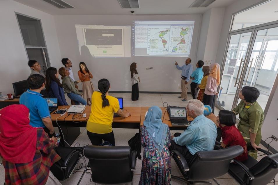
Dr. McNeil and his students analyzing data in the classroom. The projected wall image on the left shows the result of a MODIS data subset using the ORNL DAAC’s Global Subsets Tool. The projected wall image on the right shows thematic maps of daily land surface temperature increase in North and South America and Antarctica using a laterally rotated Mollweide Earth projection. Image courtesy of Dr. McNeil.
For processing and transforming these MODIS data, Dr. McNeil and his students use the Global Subsets Tool. The Global Subsets Tool was developed by NASA’s Oak Ridge National Laboratory DAAC (ORNL DAAC), which is the home for NASA EOSDIS data and information related to biogeochemical dynamics, ecological data, and environmental processes critical for understanding the biological, geological, and chemical components of Earth’s environment.
Dr. McNeil’s students have published a variety of papers that used MODIS data and analysis tools. These include a 2017 study by Wongsai, et al., (doi: 10.3390/rs9121254) that used a natural cubic spline function to examine land surface temperature seasonality and a 2018 study from I. Sharma (doi: 10.22034/IJHCUM.2018.04.02) that examined trends in vegetation and temperature around Nepal.
Through the use of NASA Earth observing data and open-source products like the Global Subsets Tool, Dr. McNeil hopes to widen his students’ research efforts and create a strong and sustainable program that will continue to attract students who want to use science to improve the world. “We are not just interested in local events,” he observes. “Climate and its impact on life on our planet is obviously one of the most important issues in today’s world, so it’s quite important that appropriate methods are used to learn what to do about it.”

