NASA’s Land Processes Distributed Active Archive Center (LP DAAC) and the Advanced Spaceborne Thermal Emission and Reflection Radiometer (ASTER) Science Team at NASA’s Jet Propulsion Laboratory (JPL) have announced a final data processing campaign that will make the entire ASTER data archive freely available and easily accessible to users around the globe.
NASA Begins Final ASTER Data Processing Campaign
The ASTER instrument travels in near-polar orbit aboard NASA’s Terra satellite, the flagship satellite of NASA's Earth Observing System (EOS), which launched in December 1999. Since then, it has collected 25 years’ worth of data used to create detailed maps of radiance, land surface temperature, emissivity, reflectance, and elevation.
“In April 2016, the entire ASTER archive was made freely available to the public. This was the period of on-demand ordering capabilities for ASTER higher-level products like surface reflectance, surface temperature, digital elevation models, and so on,” said Cole Krehbiel, Project Scientist with the U.S. Geological Survey at LP DAAC. “Now we're entering an era where all of these data are not only freely available, but easily accessible in the Earthdata Cloud. We're going to have 4.5 million scenes for each of ASTER’s 11 data products available at users’ fingertips, so they’ll no longer have to submit requests for them to be processed.”
In the parlance of ASTER, a scene is a 60 kilometer (km) by 60 km acquisition or observation of Earth’s surface with 14 bands ranging from the visible to the thermal infrared. However, unlike other space-based instruments that continuously collect observations as they orbit Earth (e.g., the Moderate Resolution Imaging Spectroradiometer (MODIS) aboard the Terra and Aqua satellites or the Operational Land Imager (OLI) aboard the Landsat 8-9 satellites), ASTER does not continuously collect data, and only collects an average of 8 minutes of data per orbit, which results in about 650 scenes per day. These acquisitions are selected and scheduled by the ASTER Science Team and generally include areas of interest to the science community. However, they may also include data acquisition requests from users.
The entire ASTER data product archive is searchable via NASA’s Earthdata Search and through LP DAAC, where users can immediately download Level 1T data for all 4.5 million ASTER observations. Users can download the static ASTER Global Digital Elevation Model (GDEM) and Global Water Bodies Database from Earthdata Search and the Japan Space Systems website. Currently, users can submit orders to process Level 1A and Level 1B radiance and higher-level data products, including surface radiance, emissivity, reflectance, kinetic temperature, and by-scene digital elevation models. When the data processing campaign is complete, users will have the complete ASTER data archive available at their fingertips and will no longer have to wait for the data they need.
“Using the same interface, users will be able to look at an ASTER scene, determine the product they want (e.g., the temperature product), and instead of it being produced and then receiving a link to download it, the data will be in the archive and they'll download it immediately,” said Michael Abrams, ASTER Science Team Lead.
Although the final ASTER processing campaign won’t result in the creation of any new ASTER data products, it will yield new versions of existing products that are directly accessible and available to users in the NASA Earthdata Cloud.
NASA's LP DAAC plans to produce final collections for the following products:
Level 1A Reconstructed Unprocessed Instrument Data doi:10.5067/ASTER/AST_L1A.003
Level 1B Registered Radiance at the Sensor doi:10.5067/ASTER/AST_L1B.003
Level 1T Registered Radiance at the Sensor - Precision Terrain Corrected doi:10.5067/ASTER/AST_L1T.003
Level 2 Surface Reflectance - VNIR & SWIR doi:10.5067/ASTER/AST_07.003
Level 2 Surface Reflectance - VNIR & Crosstalk Corrected SWIR doi:10.5067/ASTER/AST_07XT.003
Level 2 Surface Radiance - VNIR & SWIR doi:10.5067/ASTER/AST_09.003
Level 2 Surface Radiance - VNIR & Crosstalk Corrected SWIR doi:10.5067/ASTER/AST_09XT.003
Level 2 Surface Radiance TIR doi:10.5067/ASTER/AST_09T.003
Level 2 Surface Kinetic Temperature doi:10.5067/ASTER/AST_08.003
Level 2 Surface Emissivity doi:10.5067/ASTER/AST_05.003
Level 3 Digital Elevation Model doi:10.5067/ASTER/AST14DEM.003
These new versions will be produced with the same production algorithms (save for a slight change to an atmospheric variable in one of them), the same software, and the same calibration coefficients. The ASTER Level 1T product also includes updates to the input Digital Elevation Model (DEM) sources and Ground Control Points (GCPs) to match Landsat Collection 2.
“Nothing is different,” said Abrams. “The whole point is to be able to have a consistent 25-year record where you can get a scene from day one and you can compare it with a scene from today and the values you get are consistent. This is what makes Terra’s longevity and its data record so incredible and so useful. The data are consistent for a 25-year record of Earth. It’s unparalleled.”
The final ASTER data processing campaign is slated to begin in January 2025, and according to Abrams, it will take approximately 18 months to get through the ASTER data record and archive everything in the cloud before the full collections are available to the public.
Detecting Surface Change for 25 Years and Counting
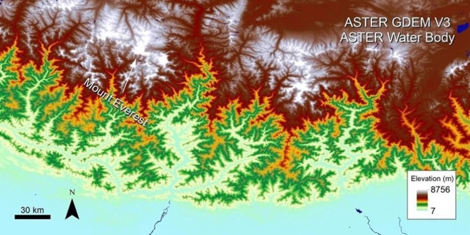
The ASTER mission is a cooperative effort between NASA and Japan's Ministry of Economy, Trade, and Industry (METI). Its three telescopes—visible and near infrared (VNIR), shortwave infrared (SWIR), and thermal infrared (TIR)—capture high-resolution (15 to 90 square meters per pixel) images of Earth in 14 different wavelengths. These capabilities make ASTER particularly useful for the study of Earth’s surface, as the data it collects are used to create detailed maps of land surface temperature, emissivity, and reflectance. Further, because ASTER has both downward- and backward-looking telescopes, the parallax can be used to produce stereoscopic images and detailed models of terrain height.
As previously mentioned, ASTER is unlike the other instruments aboard Terra in that it does not collect data continuously throughout its orbit. This is because Terra’s data storage capabilities are insufficient to hold large amounts of high-resolution data.
“At the time, technology was so rudimentary that the memory capability of Terra could not hold all our data. ASTER is the largest producer of data on Terra and takes half the memory, but our average duty cycle is about 8 percent of an orbit,” said Abrams. “If we ran all the time, we would get about 12 times more data, but there's no place to put it on Terra’s little memory chips. I think my phone has got 10 times the capability of the satellite, both in terms of computing power and memory, but that was the technology in the mid-1980s, when Terra was designed.”
Despite these technical limitations, ASTER has captured millions of scenes over its lifetime, and it continues to function normally, even though Terra has drifted to an earlier equatorial crossing time.
“Terra’s drifting hasn’t impacted ASTER at all,” said Abrams. “The orbit is slowly drifting in its crossing time and slowly getting earlier and earlier. Now it's about 9:30 a.m. and in two more years, it'll reach about 9:00 a.m. It doesn't make a whole lot of difference. The instrument is sensitive enough that it can still operate fine at 9:30 versus 10:15.”
This is not to say the impending end of the Terra mission isn’t a concern, but Abrams appreciates how long the satellite has been in orbit and the amount of data ASTER has been able to collect because of it.
“Terra’s aging. That's our big problem,” he said. “But it's amazing that a mission planned for 6 years has lasted 25. In the space business, that's almost unheard of.”
During that time, the ASTER Science Team has been able to provide the user community with a consistent suite of Level 1, 2, and 3 data products, and after 25 years, some of these ASTER products remain unmatched.
“The digital elevation model is still a unique capability. So is the nighttime thermal infrared for volcano monitoring," said Abrams. “Today, there are many other satellites that look at vegetation with better spectral and better spatial resolution, but at the time and given our capabilities, the digital elevation model, the shortwave infrared data for mineral exploration, and the multispectral thermal products were absolutely unique, and a lot of that has not been replicated or replaced."
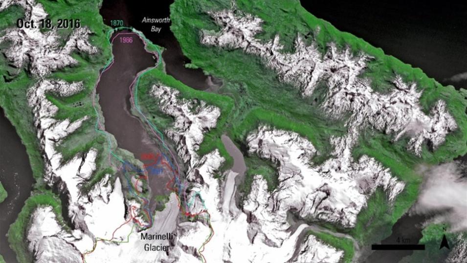
This ASTER Registered Radiance at Sensor Precision Terrain Corrected (AST_L1T) image from October 18, 2016, shows the Marinelli Glacier terminating into Ainsworth Bay. The colored lines indicate the extent of the glacier for a given year, provided by the GLIMS glacier outline database. Credit: LP DAAC.
The importance of ASTER’s unique data is evident in their contributions to entities like the Global Land Ice Measurements from Space (GLIMS) initiative, which monitors the world's glaciers with data from primarily satellite instruments, and JPL’s ASTER Volcano Archive (AVA), which collects high-resolution multispectral ASTER data and makes it available to the public. In addition, ASTER data are used in a wide array of science research and applications such as land surface climatology, vegetation and ecosystem dynamics, hazard monitoring, hydrology, geology and soils, and land surface and land cover change.
Ultimately, this range of uses for ASTER data is what makes the final reprocessing campaign so significant.
“This is kind of a treasure trove of data that, until recently, didn't really exist due to the limitations of on-demand processing. This is a lot of data. To put it into context, we're talking over 44,000,000 granules, which I think will be more than 4 petabytes of data. That's a big archive and now it’ll be in a state that's easily accessible in the cloud,” said Krehbiel. “I think there will be some really unique applications to come out of it, like looking at global elevation change over the last 25 years and analyzing global surface mineralogy maps in preparation for the forthcoming Surface Biology and Geology (SBG) mission.”
Learning Resources
ASTER tools and services at LP DAAC
ASTER e-learning resources at LP DAAC


