Jason and TOPEX/Poseidon are assembling a global, long-term record of sea surface height, which is helping scientists better understand ocean circulation and climate variability. Sea surface height reflects the storage of heat in the ocean: when the ocean warms, it expands, thus raising the sea level, explained Lee-Lueng Fu, chief scientist of the satellite missions from NASA's Jet Propulsion Laboratory in Pasadena. But detection of the recent tsunami is a good example of their secondary benefits, said Fu. "This happened by chance, because the satellites were not designed to make observations of waves moving as fast as a tsunami, which attain the speed of a jet plane in the open ocean," said Fu. "At 500 miles per hour, the waves are moving very quickly and are very hard to detect."
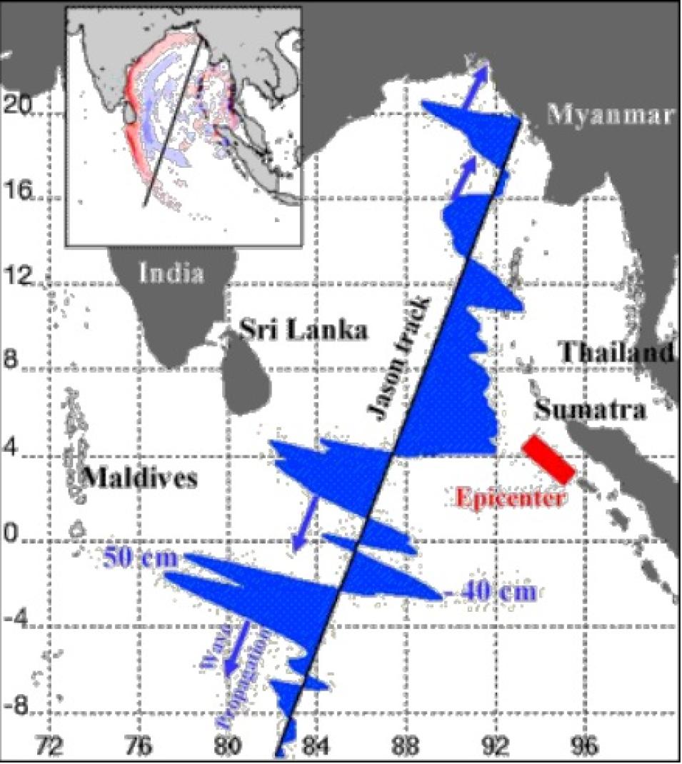
Since the satellites make 13 revolutions around Earth each day, the probability of catching a tsunami in the way that Jason and TOPEX/Poseidon did is about one chance in 50, said Fu. But their ability to detect minute changes in sea surface height enabled them to spot subtle changes in the wave behavior. When the tsunami passed through the Bay of Bengal, the satellites picked up a sea height change of half a meter, which is a huge signal, according to Fu. "This kind of first-hand knowledge is helping researchers better understand how waves propagate in the ocean," he said, "so they can refine their ability to pinpoint where the wave is going to crash over beaches and with how much energy."
To make their measurements, Jason and TOPEX/Poseidon continually bounce radar pulses off the sea surface and record the time it takes for the signal to return. Each radar pulse gives a measure of the satellites' exact location and altitude above the sea surface. Using these measurements, scientists can also calculate the velocity at which ocean currents are moving.
Jason is the satellite credited with making such precise measurements of the recent tsunami event, according to Fu. Its observations included detailed ripples — on the order of 10 centimeters high — spread over a 200-kilometer area. Previously scientists believed tsunamis to be single, fast-moving elevations of the sea surface over a span of several hundred kilometers, according to Fu. Such movement would be akin to the simple rhythmic rise and fall of taking in a deep breath and expelling it. But scientists have learned from Jason's recent observations that tsunami waves in the open ocean are more complicated than that. "This kind of measurement is telling us that a tsunami has a much more complex structure than we used to think," said Fu.
Fu is quick to point out, however, that satellites will never be able to provide a warning system from space because the cost of deploying enough satellites to be at any given point over the ocean within half an hour is prohibitive. "I don't want to give people the impression, 'oh, we caught this tsunami, therefore we should launch more satellites to catch tsunamis.' We just cannot afford to do that," said Fu. Moreover, since Jason and TOPEX/Poseidon data take a minimum of five hours to process, there is a low likelihood of using their data in time to warn coastal residents of an approaching tsunami. But in the rare case that the satellites do record the profile of a tsunami, they provide excellent hindsight because they have a continuous profile of the sea surface height change. "There's no other measurement that can produce such a record," said Fu. Ocean buoys, which are often separated by more than 500 kilometers, don't record a continuous profile.


