A new global dataset at NASA’s Socioeconomic Data and Applications Center (SEDAC) makes it easier to assess areas susceptible to industrial and agricultural development in 13 discrete sectors. The Global Development Potential Indices, v1 (2016) doi:10.7927/k9t6-gh59 consists of 78 GeoTIFF files that are available in both Mollweide and Geographic projections. The 13 sectors shown in the maps relate to renewable energy (concentrated solar power, photovoltaic solar, wind, hydropower), fossil fuels (coal, conventional and unconventional oil and gas), mining (metallic, non-metallic), and agriculture (crop, biofuels expansion).
Global Development Potential Indices Dataset Now Available at NASA’s SEDAC
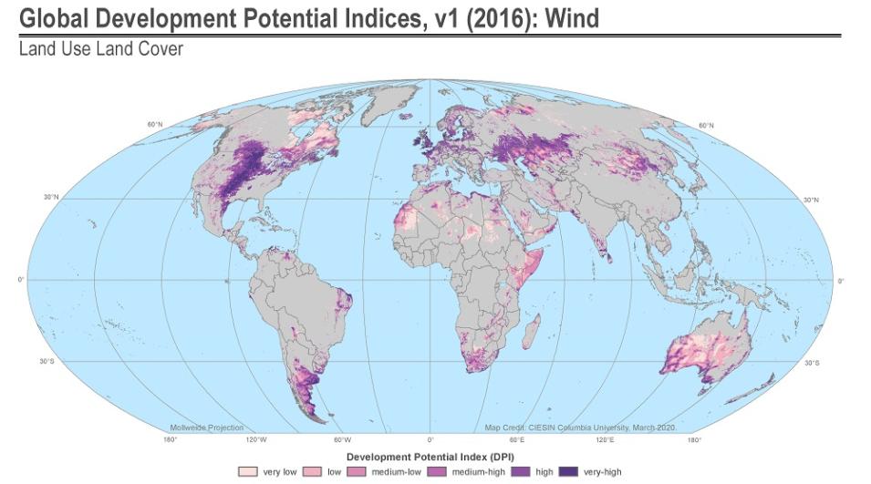
Map from the DPI dataset showing global development potential for wind power ranging from very low (light pink, left side of scale at bottom of image) to very high (dark purple on right side of scale at bottom of image). Click on image for larger view. Image: Oakleaf, J.R., Kennedy, C.M., Baruch-Mordo, S., Gerber, J.S., West, P.C., Johnson, J.A. & Kiesecker. J. (2020). “Global Development Potential Indices.” Palisades, NY: NASA SEDAC. https://doi.org/10.7927/k9t6-gh59.
A land suitability index for each of the 13 sectors, referred to as a “development potential index” (DPI), relatively ranks each 1-km area of land for its likelihood to be modified in the future by that particular sector (e.g., coal, crops, hydropower, etc.). Each sector is then classified on a high to low scale assessing development potential based on its DPI values. The DPI values, shown on the individual maps, can help facilitate broad-scale assessments of potential development patterns, and can help identify high-risk areas where development or expansion in a sector might conflict with biodiversity, climate, or environmental assets.
The new dataset is part of SEDAC’s Land Use and Land Cover (LULC) data collection that includes five global and regional datasets related to the forms of land and the uses of that land, whether natural or influenced by humans. All SEDAC datasets and data collections can be browsed freely, although an Earthdata Login account is required for downloading data.
SEDAC is the NASA Earth Observing System Data and Information System (EOSDIS) Distributed Active Archive Center (DAAC) responsible for archiving and distributing socioeconomic data in the EOSDIS collection, and is hosted at Columbia University’s Center for International Earth Science Information Network (CIESIN). SEDAC synthesizes Earth science and socioeconomic data and information in ways useful to a wide range of decision makers and other applied users, and serves as an “Information Gateway” between the socioeconomic and Earth science data and information domains.
Explore the new Global DPI dataset at NASA’s SEDAC: doi:10.7927/k9t6-gh59
