Frozen Soils and the Climate System
While scientists have learned to interpret receding glaciers as well as changing trends in snow cover, sea ice extent, and sea level as "indicators" of climate change, they are still working to better understand the role that frozen soils play within the Earth's climate system. NOAA Climate and Global Change Program administrators recently funded Tingjun Zhang, research associate at the National Snow and Ice Data Center, Cooperative Institute for Research in the Environmental Sciences, and his colleague, Richard Armstrong, to investigate the seasonal freeze-thaw cycles of soils. Their investigation is an important part of the larger Global Energy and Water Cycle Experiment (GEWEX) Continental-Scale International Project (GCIP) study regions, centered on the Mississippi River Basin.
"Research on the effects of frozen soil indicates that it has a significant influence on land surface and overlying atmospheric processes," Zhang says. "The timing, duration, thickness and distribution of frozen soils are primarily controlled by heat exchange between the atmosphere and land surface. Changes in any of these events are good indicators of climate change."
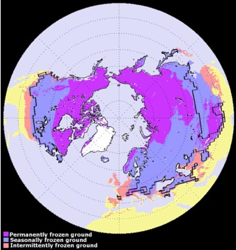
The image above shows the distribution of permafrost and average maximum extent of seasonally and intermittently frozen ground in the Northern Hemisphere. "Seasonally frozen ground" (blue regions) refers to those areas where soil is frozen for 15 days or more per year, while "intermittently frozen ground" (pink regions) refers to areas where the soil is frozen for fewer than 15 days per year. The solid line indicates the average maximum extent of the seasonal snow cover. Permafrost occupies about 22.79 million km-squared or 23.9 percent of the exposed land surface. On average, the maximum extent of seasonally frozen ground is about 55 million km-squared or 55 percent of the total land area, while the maximum snow cover extent is about 47 million km-squared or about 47 percent of the total land surface in the Northern Hemisphere.
According to Zhang, 55 percent to 60 percent of the exposed land surface in the Northern Hemisphere freezes and thaws seasonally, with tremendous impact to ecosystem diversity and productivity. Freezing and thawing cause changes in soil structure, affect the cycle of water on and below the land surface, and regulate the availability of nutrients in the soil for plants and biota that depend upon them.
"Even a thin frozen layer can essentially halt the moisture exchange between the atmosphere and soils," Zhang says. Frozen soil possesses a large apparent heat capacity, consuming or releasing about 80 times the amount of energy in freezing or thawing than is consumed or released by water during heating and cooling.
Additionally, the processes of freezing and thawing soil can affect the decomposition of organic substances in the soil as well as impact the migratory patterns and physiology of biota living in the soil. Greenhouse gas exchange between the atmosphere and land surface may be minimal when soil is frozen, but can increase following spring thaw in a dramatic release noted in research as "respiratory burst."
Unless snow cover is thin, its overall effect is to insulate soil and keep soil water from freezing. Over the past 20 years, snow area extent has decreased in the Northern Hemisphere, leaving more ground exposed to the cooling effects of air temperatures. However, at the same time air temperatures have increased nearly 1 degree Celsius over the same region. Two key questions for researchers are: How will seasonally frozen soils respond to these ongoing changes in climate? and How will the climate, in turn, be affected by the freezing and thawing patterns of the soils?
After an analysis of field measurements taken from sources such as the University of Minnesota, the National Water and Climate Center Natural Resources Conservation Center, and the National Science Foundation Niwot Ridge Long Term Ecological Research Program operated by the University of Colorado, the researchers will expand their study to regional scales. Using EASE-Grid passive microwave satellite data available from NASA's National Snow and Ice Data Center Distributed Active Archive Center (NSIDC DAAC), they expect to improve and validate a remote-sensing algorithm that will detect surface soil freeze-thaw status over snow-free land surfaces. A validated numerical model will be employed to predict soil freeze-thaw status and freeze-depth under seasonal snow cover.
The graphs above show the extent of frozen soils (A) and snow cover (B) over the GCIP regions from October 1, 1997 through January 31, 1998. Frozen soil area (A) over snow-free land increased sharply in the early winter, reached its maximum in mid-November, then declined due to the increase in snow covered area. Zhang and Armstrong will determine soil freeze-thaw status under snow cover using remote sensing techniques and numerical modeling.
Ultimately, Zhang and Armstrong will characterize the climatology — timing, duration, thickness and areal extent — of seasonally frozen soils over the entire GCIP region from 1978 forward. The data set generated will be archived at NSIDC DAAC and made available to researchers.
Reprinted from the Earth System Monitor
References
Skogland, T.S., Lomeland, and J. Goksoyr, 1988: Respiratory burst after freezing and thawing of soil: experiments with soil bacteria. Soil Biol. Biochem., 20, pp. 851-856.
Zhang, T., Roger G. Barry, K. Knowles, J. A. Heginbottom, and J. Brown, 1999: Statistics and characteristics of permafrost and ground ice distribution in the Northern Hemisphere, Polar Geography, 23(2), pp. 147-169.
For more information
NASA National Snow and Ice Data Center Distributed Active Archive Center (NSIDC DAAC)
U.S. Fish and Wildlife Service's Arctic Refuge
| About the remote sensing data used | ||
|---|---|---|
| Data | EASE-Grid | |
| Parameter | frozen ground and ecosystem productivity | |
| DAAC | NASA National Snow and Ice Data Center Distributed Active Archive Center (NSIDC DAAC) | |


