Fathoming Antarctica

Lakes hidden under the Antarctic ice sheet may play a role in its stability.

On a brisk April day in a Colorado Springs lecture hall, geophysicist Robin Bell showed the audience three photographs of water. The first was a placid lake dotted with sailboats. The second was a gushing river. The third was not of a body of water at all, but a thin film of water trapped under a melting ice cube. Bell said, “My colleagues and I wonder whether subglacial lakes in Antarctica look like any of these—minus the sailboats, of course,” and drew a collective chuckle from the audience.

Bell, a senior research scientist at Columbia University’s Lamont-Doherty Earth Observatory in New York, has a knack for inspiring an audience to pause and consider the seemingly inconceivable. Just what does a body of water look like when it is buried under a two-mile thick slab of ice? “Is it calm or turbulent down there?” she asked. “Or is it a very thin film of water, like what would form between an ice cube and your warm hand? What does that tell us about processes happening deep under the Antarctic ice?”

Lake Vostok
Image Caption

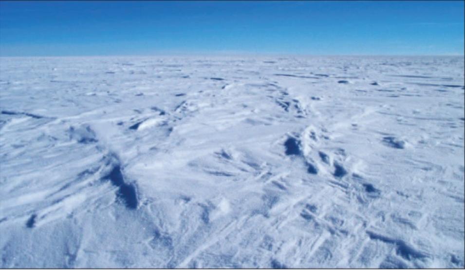
The surface above Lake Vostok, hidden under more than a kilometer of ice, looks like most of Antarctica’s landscape—flat, barren, and icy. The best way to detect a subglacial lake is through remote sensing. (Courtesy M. Studinger, LDEO)

In the last fifty years, researchers like Bell have found unexpected clues about what lies beneath the barren ice desert of Antarctica. One of the most exciting finds has been the detection of subglacial lakes scattered underneath the East and West Antarctic ice sheets. Bell suspects that these mysterious, hidden lakes are key to understanding the interplay between ice sheets and the world’s oceans.

Flat lines in the ice

Antarctica, an island continent larger than Australia, is almost completely covered by ice and remains the most mysterious terrain on Earth. The stormy waters of the Southern Ocean isolate it from other lands. And because it is the coldest, windiest and driest place on the planet, it has been difficult to study and explore. “It seemed at first that the study of Antarctica was falling through the cracks,” Bell said. “Because it was so difficult to get to, the biologists didn’t care, and because the environment was so extreme, the glaciologists didn’t care.”

But some scientists did care. They thought that the ice sheets concealing Antarctica might also conceal clues to the continent, and to the climate in this remote part of the Earth and beyond. In the 1950s, glaciologist Gordon de Quetteville Robin was captivated by the idea that water could be present under the ice sheet. He suggested that geothermal heat from Antarctica’s bedrock could be hot enough to heat the ice sheet base, and that the ice sheet itself could be thick enough to insulate its base from its cold surface. Robin could not prove this until the 1970s, when ice-penetrating radar was developed.

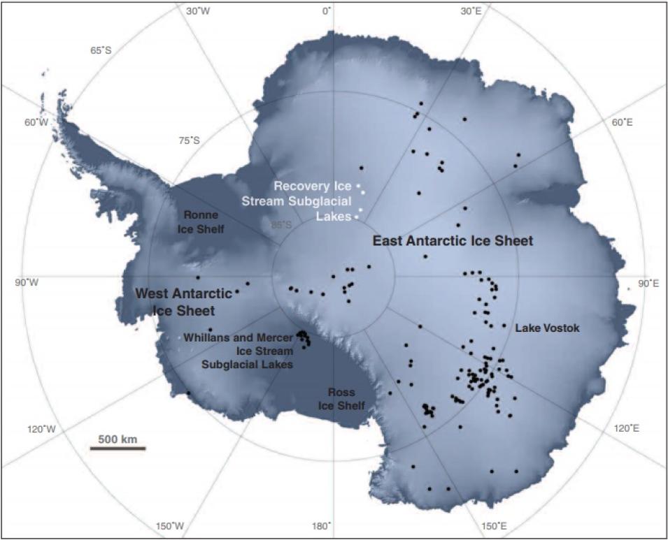
subglacial lake map
Image Caption

In the 1950s, glaciologist Gordon de Quetteville Robin suggested that liquid water could be present between Antarctica’s geothermal bedrock and its ice sheet. More than fifty years later, over 200 subglacial lakes have been discovered underneath the ice of Antarctica, some of which are marked with white and black with dots on this map. (NASA map by R. Simmon, based on data from the RADARSAT-1 Antarctic Mapping Project, T. Scambos, C. Shuman, and M. J. Siegert)

“Scientists flew around Antarctica in C-130 airplanes that sent electromagnetic waves through the ice sheet,” Bell said. “It turns out that an ice sheet is very much like a layer of sedimentary rock. At the bottom were outlines of rugged mountains. But in some places, the layers looked really flat. These were actually subglacial lakes, our first indication that there was indeed water underneath the ice sheet.”

The Lake Vostok surprise

Still, scientists did not know what to make of these mysterious features. “In the 1970s, we thought that those flat layers were tiny, isolated ponds sprinkled around in obscure little canyons, speckles on top of the continent,” Bell said. “Quite frankly they didn’t seem to be important. We didn’t have a sense that the lakes were actually very big.”

To learn more, Bell and colleagues had to wait until the 1990s, when the European Remote Sensing satellite (ERS-1) completed the first comprehensive map of Antarctica’s ice surface, using radar altimetry. European scientists examining the map noticed a curiously flat region in the center of the ice sheet, roughly the size of Lake Ontario in Canada. Bell said, “It turns out that ice stuck on top of a mountain, even when it is a couple of kilometers [1 to 2 miles] thick, will preserve the shape of the mountain underneath. The ice surface will look rugged. But if water is underneath, the ice surface will look very flat.” This enormous subglacial lake was named Lake Vostok, after the Russian research station located on the ice above it.

ICESat profile
Image Caption

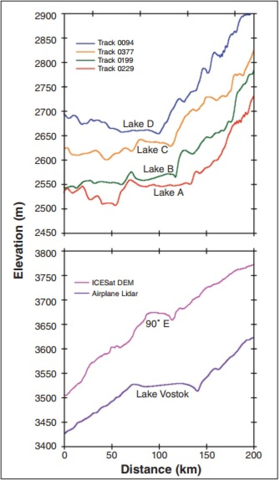
Subglacial lakes show up in satellite data as upstream troughs and downstream ridges bounding relatively flat, featureless regions. At top, ice surface elevation data from the Ice, Cloud, and Land Elevation Satellite (ICESat) show the profiles of the four Recovery subglacial lakes, with blue, yellow, green, and red lines. At bottom, ICESat and aircraft-borne lidar show profiles for Lake Vostok and Lake 90°E, in purple and lavender. Although the profile for 90°E lacks a flat surface, it does show the characteristic depression over the upstream shore line and a ridge over the downstream shoreline. (Courtesy C. A. Shuman and V. Suchdeo, NASA Goddard Space Flight Center)

It would take another decade and improvements in remote sensing technology before scientists could learn more. By that time, other subglacial lakes had been discovered, and scientists were also interested in ice sheet dynamics, the processes that add to or subtract from the mass of an ice sheet, and affect its stability. In 2006, Bell and Chris Shuman, at NASA's Goddard Space Flight Center, obtained new data from the NASA Ice, Cloud, and Land Elevation Satellite (ICESat). The ICESat data, which are archived and distributed by NASA's National Snow and Ice Data Center Distributed Active Archive Center (NSIDC DAAC), had been specially processed at Goddard.

Bell, Shuman, and Michael Studinger, also at the Lamont-Doherty Earth Observatory and Bell’s co-investigator, looked at ice surface elevation profiles for a portion of Queen Maud Land in East Antarctica, a region previously beyond the coverage of many satellites. They found not only one, but four new subglacial lakes. Their location made Bell curious about what role the new lakes might play in the flow of ice from Antarctica’s higher elevations down to sea level, where the ice sheet calves icebergs into the oceans.

Flats, ridges, and troughs

Subtle features in the ICESat data tipped off the researchers to the lakes. Studinger said, “There are a few ways to recognize a subglacial lake. The ice surface is very flat and is bounded by troughs about 2 to 15 meters [7 to 49 feet] deep, and ridges about 2 to 5 meters [7 to 16 feet] high.” Looking at ICESat ice elevation profiles east of Filchner Ice Shelf and the Recovery Ice Stream, the team spotted four features that bore these characteristics.

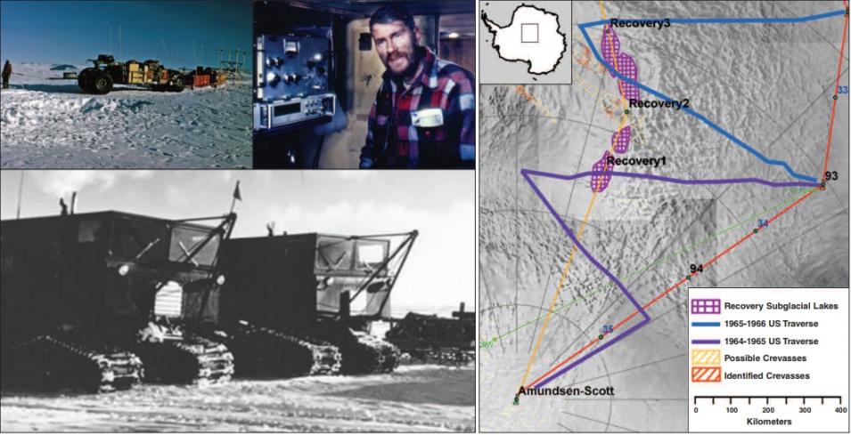
On a hunch, Bell requested unpublished radar data from a 1964 to 1966 surface traverse in Queen Maud Land, a little-explored region of the East Antarctic ice sheet. Bell said, “That traverse went across where these lakes should be, but nobody had ever looked at the data.” She received old, smudged notebooks of radar readings and had the data digitized. True enough, whenever the traverse was over any of the lakes, the logs showed consistent ice thicknesses. “Those researchers in 1964 thought something was terribly wrong because they kept getting the same measurements,” Bell said. “What they didn’t know was that they were over subglacial lakes.”

With the ICESat data and the old traverse notebooks confirming the signal of the lakes, Bell wanted to know how large they were. She sought a larger-scale view of the area, so she consulted a digital image map, constructed from Moderate Resolution Imaging Spectroradiometer (MODIS) data, which are available from NASA’s Level 1 Atmosphere Archive and Distribution System (LAADS) Distributed Active Archive Center (DAAC). The map, called the Mosaic of Antarctica (MOA) and distributed by NASA's National Snow and Ice Data Center (NSIDC) DAAC, is a cloud-free image of the continent composed of 260 orbital swaths of imagery acquired in 2003 and 2004. A close look at the map revealed four slug-shaped depressions on the ice surface with a combined total area of 13,300 square kilometers (5,130 square miles), comparable to that of Lake Vostok at 15,690 square kilometers (6,058 square miles). Each of the new lakes ranked among the largest of all previously identified subglacial lakes in Antarctica.

Queen Maud Land Traverse
Image Caption

The Queen Maud Land Traverse in the late 1960s measured ice thicknesses using radar equipment, dragged across the ice by sledges (upper left) and by tracked all-terrain vehicles (bottom). The data they recorded puzzled the traverse team; only recently have scientists decoded it as evidence of lakes beneath the ice. The traverse crew sat in tight compartments in the Sno-Cat vehicles, taking measurement readings (top, center). The map at right shows the 1964 to 1966 traverse routes in purple and blue. (Upper left photograph courtesy O. Orheim; upper right photograph courtesy J. Clough; bottom photograph courtesy C. Bentley; map courtesy S. Tronstad/Norsk Polarinstitutt)

Giant conveyor belts of ice

Something else was different about these four features. “Instead of being in the middle of the ice sheet like most previously discovered subglacial lakes, they were near a huge and rapidly flowing ice stream,” Bell said. Ice streams are rivers of ice within an ice sheet that transport inland ice into the ocean, like giant conveyor belts that move as fast as 152 meters (499 feet) per year in some areas and as slow as 3 meters (10 feet) per year in others. The proximity of four subglacial lakes to a rapidly flowing ice stream suggested that these bodies of water were more like gushing rivers than the placid lakes she had imagined.

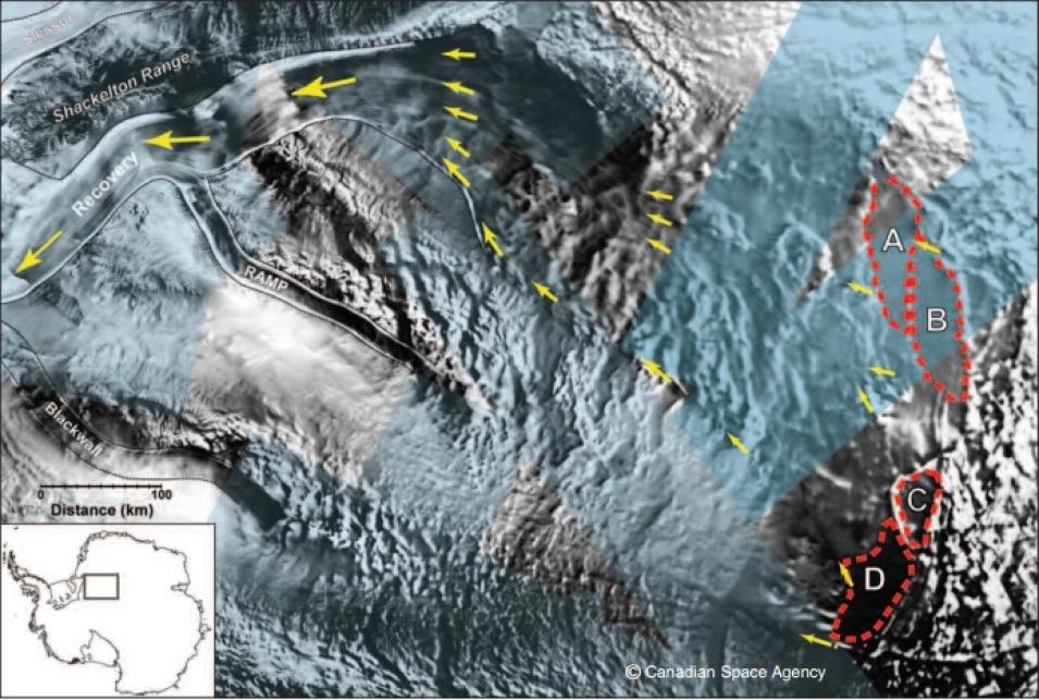
The four new lakes are located where the Recovery Ice Stream widens and accelerates. Ice streams typically get narrower upslope, but the Recovery Ice Stream widens from 30 kilometers (20 miles) to 90 kilometers (60 miles) eastward near the lakes. Ice velocity data from the Synthetic Aperture Radar (SAR) instrument on the RADARSAT-1 satellite, distributed by NASA's Alaska Satellite Facility (ASF) DAAC, showed accelerated ice movement of 20 to 30 meters (70 to 100 feet) per year farther east, downstream of the four lakes. MOA images of this area of accelerated ice flow showed that it was full of crevasses, or open fissures in the ice. “When ice accelerates, it stretches and cracks,” Bell said.

recovery lakes
Image Caption

The Recovery Lakes supply water that lubricates the bottom of Antarctica’s ice sheet, speeding the Recovery Ice Stream’s flow toward the ocean. The lakes are indicated with dotted, red lines and identified with the letters A, B, C, and D.Yellow arrows indicate the Recovery Ice Stream’s flow. Light blue indicates the coverage of Synthetic Aperture Radar data from the RADARSAT-1 satellite, which was used to measure the velocity of the flow. (Courtesy C. A. Shuman and V. Suchdeo, NASA Goddard Space Flight Center)

The researchers now see a strong connection between the four Recovery Lakes and the ice stream. Bell and Studinger concluded that the Recovery Ice Stream originates at the lakes. It is the first time subglacial lakes have been connected to ice streams. “Suddenly these lakes went from being just this cool ecosystem to being a fundamental part of ice sheet dynamics and how ice is delivered to the oceans,” she said. Bell thinks that subglacial lakes warm up the underbelly of an ice sheet. She also suggested that subglacial lakes provide a supply of water that lubricates the bottom of the ice sheet, allowing it to move faster toward the ocean.

To date, over 200 subglacial lakes have been discovered underneath the ice of Antarctica. Studinger said, “What scientists now know is that these lakes are not as isolated as once thought.” Remote sensing has shown that the ice surface above these subglacial lakes can either drop or pop up thirty to forty feet in two months. Based on this information, colleague Helen Fricker suggested that water moves out of one lake and into the next. Studinger said it is important to ask how the presence of water under the ice sheets can impact their stability.

Bell said, “Liquid water plays a crucial and, until quite recently, underappreciated role in the internal movements and seaward flow of ice sheets. Understanding how liquid water forms under an ice sheet, where it occurs and how climate change can intensify its effects on the world’s polar ice are paramount in predicting—and preparing for—the consequences of global warming on sea level.”

References

Bell, R. E., M. Studinger, C. A. Shuman, M. A. Fahnestock, and I. Joughin. 2007. Large subglacial lakes in East Antarctica at the onset of fast-flowing ice streams. Nature 445, doi:10.1038/nature05554.

Bell, R. E. 2008. Unquiet ice speaks volumes on global warming. Scientific American, February 2008, 60.

Scambos, T. A., T. M. Haran, M. A. Fahnestock, T. H. Painter, and J. Bohlander, 2007. MODIS-based Mosaic of Antarctica (MOA) data sets: Continent-wide surface morphology and snow grain size. Remote Sensing of Environment 111(2-3): 242−257, doi:10.1016/j.rse.2006.12.020.

Siegert, M. J. 2000. Antarctic subglacial lakes. Earth-Science Reviews 50:29–50.

Studinger, M., et al. 2002. Origin and fate of Lake Vostok water frozen to the base of the East Antarctic ice sheet. Nature 416: 307−310 (21 March 2002), doi:10.1038/416307a.

For more information

NASA Alaska Satellite Facility Distributed Active Archive Center (ASF DAAC)

NASA National Snow and Ice Data Center DAAC (NSIDC DAAC)

Geoscience Laser Altimeter System (GLAS)

Moderate Resolution Imaging Spectroradiometer (MODIS)

Mosaic of Antarctica (MOA)

About the remote sensing data
Satellites Ice, Cloud, and Land Elevation Satellite (ICESat) Terra and Aqua Terra and Aqua Canadian Space Agency RADARSAT-1
Sensors Geoscience Laser Altimeter System (GLAS) Moderate Resolution Imaging Spectroradiometer (MODIS) MODIS Synthetic Aperture Radar (SAR)
Data sets GLA06 Release 424 MODIS Level 1B Calibrated Radiances MOD02QKM (Terra), MYD02QKM (Aqua) Mosaic of Antarctica (MOA) Antarctic Mapping Mission
Resolution 172 meter along track 250 meter 250 meter 1.0 kilometer (velocity)
Parameters Ice sheet elevation profiles Radiances Digital image map Ice velocity
DAACs NASA National Snow and Ice Data Center Distributed Active Archive Center (NSIDC DAAC) NASA Level-1 and Atmosphere Archive and Distribution System DAAC (LAADS DAAC) NSIDC Antarctic Glaciological Data Center NASA Alaska Satellite Facility DAAC (ASF DAAC)

The table above lists the public NASA archive for these remote sensing data sets. Bell and Studinger used the GLA06 data set with a spatial resolution of 172 meters along track (plus DEM v1, gridded at 500 meters), with additional processing from Goddard.
Details

Last Updated

Published

Data Center/Project

Alaska Satellite Facility DAAC (ASF DAAC)
Level 1 and Atmosphere Archive and Distribution System DAAC (LAADS DAAC)
National Snow and Ice Data Center DAAC (NSIDC DAAC)