Growing Jamaica

Local knowledge plus satellites may help farmers catch a crop.

In scorching heat and dry wind, geographer Donovan Campbell works alongside farmers in St. Elizabeth, Jamaica. It is June and the perennial mid-summer drought has already arrived, as evident by wilted scallions and deflated watermelons dotting the hillside. As farmers dip mason jars into buckets of water to carry to each plant, Campbell presses the record button on his video camera. He interviews them as they spread dried guinea grass over their fields to retain precious soil moisture, and reminisce about years when rainfall was more reliable. He wants to learn how they manage to grow food during a drought, what the farmers call catching a crop. Though their tools and methods are simple, the farmers have a complex understanding of local climate patterns. But these patterns are changing, and to help the farmers survive, Campbell too used a simple tool to bring their local knowledge together with sophisticated satellite data.

Ground-level knowledge

Hoping to study how farmers cope with drought, and to bring science to bear on their situation, Campbell relocated from the University of the West Indies in Kingston to St. Elizabeth in 2007. A native Jamaican from a rural family, Campbell conversed with them in Patois, a creole language that is spoken in many farming communities, but is rarely written. He focused on farmers who tend three acres or less. Their small-scale farms are the backbone of domestic food production. But their farms are in danger of disappearing, pummeled by years of drought, water costs that doubled in just two years, plus higher prices for supplies, like mulch and fertilizer. Such problems all but blotted out Jamaican onion farms in three years, with 800 hectares (2,000 acres) dwindling to a handful by 1999.

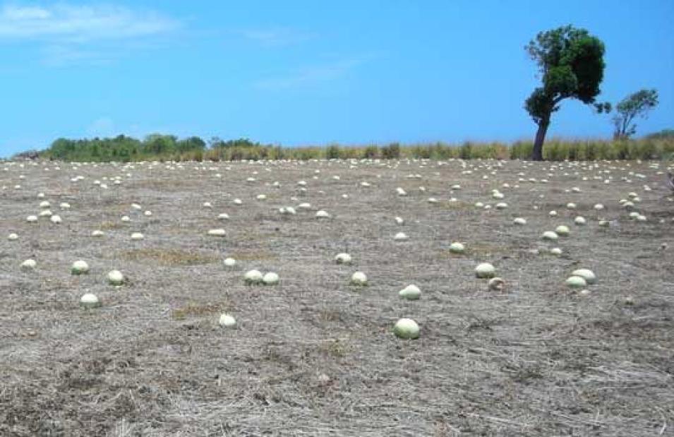
Photograph of a drought-stricken melon field in Jamaica
Image Caption

This photograph shows a melon farm in southern St. Elizabeth, Jamaica destroyed by drought. Of all the challenges farmers in the region face, including crippling storms and floods, drought poses the greatest. In spite of watering and tending his field for weeks, this farmer lost his entire crop. (Courtesy D. Campbell)

Of all these problems, drought is the hardest to solve. To make matters worse, the farmers have noticed the mid-summer drought arriving earlier and sticking around longer. What once seemed extreme, they said, has become the norm. Campbell wondered if he could capture their view in scientific data. He said, “These farmers have lived in the area for many, many decades, so they are more familiar with the conditions than any scientist.” But if scientific measurements also pointed to changing climate patterns, it might help shape solutions or even bring government attention to the situation. So he set about to learn what the farmers experienced, and to find if there were data to support their intuitions.

Shrouded in shadow

Jamaica’s breadbasket is nestled in the southern section of St. Elizabeth Parish, one of the island’s fourteen subdivided counties, where over 70 percent of people depend on farming for their livelihood. Fresh scallion, sweet peppers, melons, and cassava—a root tuber ground into flour and used for making bammies, or flatbread—have fed Jamaicans for generations. Steep farmlands run south from the slopes of the Santa Cruz Mountains to the rocky coast of the Caribbean Sea. As one farmer explained to Campbell, “[Farming] is not a bed of roses these days, but for most of us here in St. Elizabeth, farming is the only thing we know. It is in our blood.”

Ironically, this breadbasket sits in a rain shadow and receives less rainfall than the rest of the island. When prevailing winds flow northeast from the Atlantic across Jamaica, they bring moist, warm air necessary for forming rain clouds. But the Santa Cruz Mountains block the passage of the prevailing winds and the rain systems they bring, leaving southern St. Elizabeth on the dry side of the mountains. 

Talking to the farmers, Campbell learned that they have honed a complex crop schedule over many decades to fit the local climate. Two dry seasons, one in July and one from December through March, interrupt the growing season. So they plant quick-growing crops for April through June, and this early-season harvest finances their late-season cash crops, which they grow from August through November. The cash crop season also coincides with the main hurricane season, which can bring crippling storms and floods.

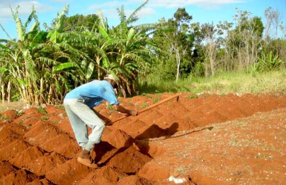
Photograph of a Jamaican farmer hoeing his fields
Image Caption

A hearty 75-year-old farmer in southern St. Elizabeth, Jamaica prepares his field for planting his next crop of potatoes. (Courtesy D. Campbell)

Even so, drought poses a greater challenge, particularly for small-scale farmers who lack running water and irrigation systems. Campbell said, "The difficulty with drought is you don't know when it starts and you don’t know when it ends." So when the dry season arrives, they must tap into limited reserves of water stored in shared stone water tanks, called catchments, and eventually into limited reserves of cash to have these catchments refilled. They also have to pay for more guinea grass mulch in an attempt to lock in soil moisture, and for more fertilizer to coax their ailing crops along. "So a farmer will expend a lot of his resources during a drought," Campbell said. And when below-average rainfall turns the dry season into an extended drought, Jamaica’s shallow aquifers quickly dry up, too, leaving everyone's buckets and mason jars empty.

Verifying local observations

Campbell needed a long series of rainfall records to show that patterns had truly changed. The challenge was finding those records. Farmers' memories of weather events stretched back thirty years or more, but local land-based rain gauge measurements provided spotty data, and for just five to ten years. So he worked with climatologists Doug Gamble at the University of North Carolina Wilmington and Scott Curtis at East Carolina University to obtain satellite data.

At NASA's Goddard Earth Sciences Data and Information Services Center (GES DISC), they found Tropical Rainfall Measuring Mission (TRMM) satellite data and a visualization tool called the GES DISC Interactive Online Visualization and Analysis Infrastructure (Giovanni) that simplified the process of getting and using rainfall data for St. Elizabeth. Curtis said, "You can get the data you want without being overloaded with megabytes of data. And the TRMM data have a fine time and space scale that allows you to zoom in on a particular parish."

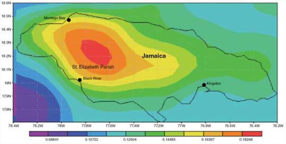
First the team studied average monthly rainfall maps online for the entire island, then focused in on St. Elizabeth in 25-kilometer (16-mile) square chunks. The TRMM record was complete. It provided over thirty years of daily rainfall data, and included other satellite data to fill any gaps. The researchers found that drought events have indeed become more frequent and severe over the past twenty years. Gamble said, "What's most interesting is, if you look at the overall trend of rainfall, yes, there’s a decrease, but that’s not the real story."

Data image showing rainfall patterns over Jamaica
Image Caption

To understand how drought affects farmers in St. Elizabeth, Jamaica, scientists compared farmers’ local knowledge of rainfall patterns with rainfall data from the Tropical Rainfall Measuring Mission (TRMM) satellite. This TRMM data image shows the spatial distribution of rain in millimeters per hour over Jamaica from May 1998 through May 2010. Red, orange, and yellow areas received the most rain. (Courtesy D. Campbell/NASA GES DISC)

The team made a breakthrough when they looked at the data through the farmers' eyes. Gamble said, "If we hadn't talked to the farmers and realized how important the early season is, we wouldn't have broken it into an early season and a late season." Most previous work had focused on the intensity and length of drought as the most threatening factors to crops. But for farmers, timing is critical. Misjudging a season by one week can undermine their ability to bring a mature crop to market, and to finance their next growing season. "So it made us look at the data in a different way and we found something very important, that drought is much more prevalent at the beginning of the year," Gamble said.

Hope of relief

But if the Jamaican government or relief organizations could help these farmers, when would they step in? The data on drought timing provided the answer. Gamble said, "We validated what the farmers said and it gives us a nice foundation. It gives us a way to not only address drought, but to address the early drought as compared to the later drought." Supplemental water delivery to farmers during this critical time, for example, could provide substantial relief. Campbell said, "So it shows you that what the farmers are experiencing in these communities is where we should be focusing our research."

Yet larger questions still loom. What are the best options for helping farmers adapt? Will drought get even worse in the future? To build a clear picture, Campbell continues to work with farmers and is expanding the study area to other agricultural regions in Jamaica. Meanwhile, Gamble and Curtis are busy analyzing satellite vegetation data to understand how drought affects local crops. The team plans to outfit fields with rain gauges and involve farmers in active climate monitoring. They hope that, by strengthening the view from space with what the farmers see in their fields, these questions too will be answered. Gamble said, "I can find a trend within that satellite data, but if the farmers aren’t worried about it, then that trend doesn’t matter."

References

Allen, T., S. Curtis, and D. Gamble. 2010. The midsummer dry spell’s impact on vegetation in Jamaica. Journal of Applied Meteorology and Climatology 49(7): 1,590–1,595, doi:10.1175/2010JAMC2422.1

Campbell, D., D. Barker, and D. McGregor. 2011. Dealing with drought: Small farmers and environmental hazards in southern St. Elizabeth, Jamaica. Applied Geography 31(1): 146–158, doi:10.1016/j.apgeog.2010.03.007

Gamble, D. W., D. Campbell, T. L. Allen, D. Barker, S. Curtis, D. McGregor, and J. Popke. 2010. Climate change, drought, and Jamaican agriculture: local knowledge and the climate record. Annals of the Association of American Geographers 100(4): 880–893, doi:10.1080/00045608.2010.497122

Related Links

NASA Goddard Earth Sciences Data and Information Services Center (GES DISC)

Tropical Rainfall Measuring Mission (TRMM)

GES-DISC Interactive Online Visualization and Analysis Infrastructure (Giovanni) website

Donovan Campbell

Scott Curtis

Douglas W. Gamble

About the remote sensing data used
SatelliteTropical Rainfall Measuring Mission (TRMM)
SensorTRMM Microwave Imager
Data setsTRMM Level 3 Monthly Data Products
Resolution25 degree
ParameterPrecipitation
DAACNASA Goddard Earth Sciences Data and Information Services Center (GES DISC)
The images and data used in this study were acquired using the Giovanni as part of GES DISC.

The photograph in the title graphic shows a Jamaican farmer spreading guinea grass over his field to help the soil hold in moisture. (Courtesy D. Campbell)
Details

Last Updated

Published

Data Center/Project

Goddard Earth Sciences Data and Information Services Center (GES DISC)