SmallSat Coming to AMS

Two IMPACT team members who are part of the Commercial SmallSat Data Acquisition (CSDA) program will be presenting at the American Meteorological Society’s 2022 Annual Meeting.

Coming up quickly in the new year is the American Meteorological Society’s 2022 Annual Meeting on January 23rd. Two IMPACT team members who are part of the Commercial SmallSat Data Acquisition (CSDA) program will be presenting several of the research and projects focused on small satellite imagery data.

Brad Baker will be presenting “Tornado Path Detection Using High-Resolution SmallSat Imagery Data” that demonstrates the use of the normalized difference vegetation index (NDVI) from high resolution commercial imagery to identify tornado damage paths. NDVI is a calculated indicator that provides a baseline for vegetation health by measuring the absorption and reflection of near infrared and red light by plants. Tornadoes can disturb vegetation, and the use of NDVI can potentially detect this disturbance to surface vegetation. This research used PlanetScope imagery to evaluate several tornado events across a range of locations, seasons, and Enhanced Fujita scale tornado intensities. NDVI was calculated using imagery obtained approximately one month or less prior to the event and also from the days following the tornado. NDVI values, calculated using both the before and after images were then differenced to identify the tornado damage paths. This analysis was repeated using three other satellite imagery datasets, MODIS Terra, Landsat 8, and Sentinel-2 which all have lower spatial resolution than the PlanetScope imagery. The results from this analysis show promise for using commercial high-resolution data in the detection of tornado damage paths. Catch this talk on January 27th at 9:30 AM.
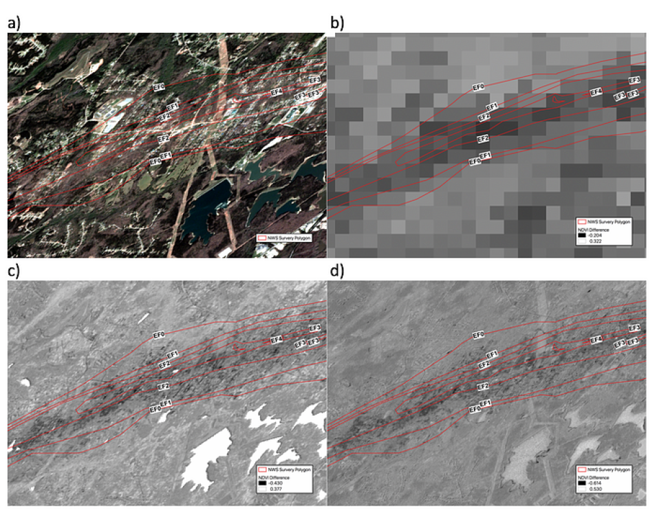
Four raw images of the 25 March 2021 Newnan, GA tornado.
Image Caption

a) Raw image of the 25 March 2021 Newnan, GA tornado. Imagery acquired ten days after the tornado on 6 April 2021 from PlanetScope 4 band, b) NDVI difference image (derived by subtracting the difference between NDVI calculated before and after the tornado) using MODIS imagery taken before (20 March 2021) and after (2 April 2021) the tornado, c) NDVI difference image using Sentinel imagery taken before (20 March 2021) and after (4 April 2021), and d) NDVI difference image using PlanetScope 4-band taken before (22 March 2021) and after (6 April 2021). For each image, the National Weather Service damage survey polygons are represented as red lines and the values correspond to the Enhanced Fujita (EF) tornado intensity scale. The maximum rating of the tornado was an EF4. Raw image © Planet Labs PBC 2021. All rights reserved. NDVI derived images include copyrighted material of Planet Labs PBC. All rights reserved.

Aaron Kaulfus will provide in-depth details on data management activities of the CSDA Program in the presentation titled “NASA’s Commercial SmallSat Data Acquisition Program Data Stewardship and Data Management System.” Initiated in 2017, NASA’s CSDA Program was established to identify, evaluate, and acquire data from commercial SmallSat companies that have the potential to support and complement NASA’s Earth science missions, ongoing research, and applications development goals.

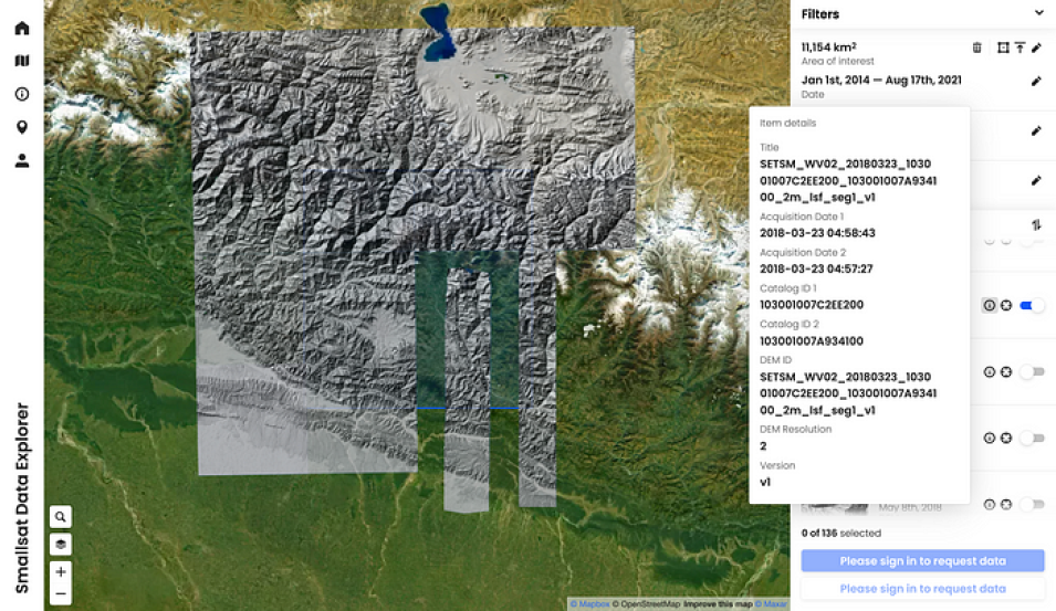
SmallSat Data Explorer showing EarthDEM mosaics and strips from a region over DEMs.
Image Caption

The SmallSat Data Explorer showing EarthDEM mosaics and strips from a region over DEM(s) courtesy of the Polar Geospatial Center. We acknowledge the use of imagery from the SmallSat Data Explore application (https://csdap.earthdata.nasa.gov), part of the NASA Commercial SmallSat Data Acquisition program.

Over the past decade, the Earth observing commercial satellite industry has expanded rapidly. These commercial observing systems often consist of constellations of small satellites, or SmallSats, capable of global scale observations on short time scales resulting in petabyte-scale archives of observations. The SmallSat Data Explorer, developed as part of NASA’s CSDA program, is used to search, discover, and access commercial small satellite (or SmallSat) data that has been acquired by NASA. In order for data acquired through the CSDA program to be made available to the broader scientific research community, the CSDA data team is developing scalable, efficient, continuous, and repeatable data management processes. In addition, the CSDA program seeks to support the search and discovery expectations of the existing community, to actively identify new science communities, and to develop innovative data management capabilities with user interfaces to engage new science users. This presentation will provide an update on CSDA program activities including information about the data availability, with a focus on data stewardship and data management activities, as well as end user support efforts undertaken by the CSDA program.

Details

Last Updated

Published