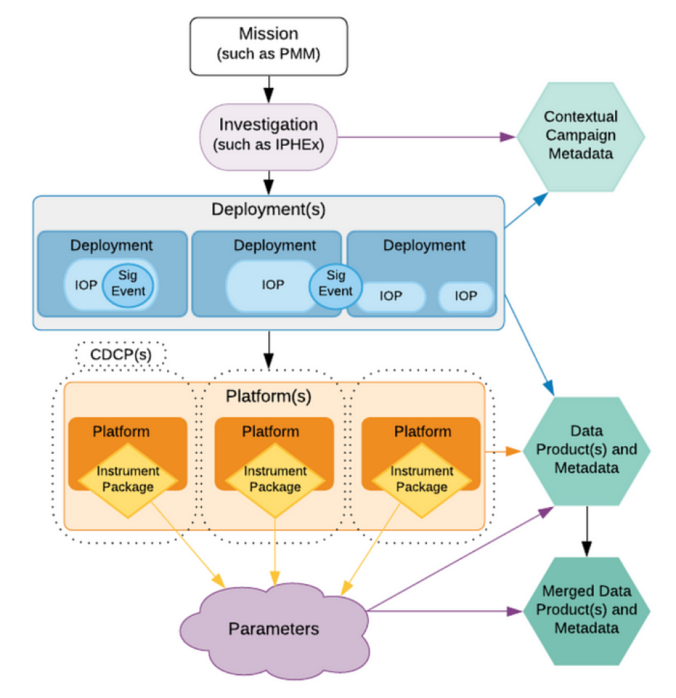
ADMG’s CASEI metadata curation efforts revolve around locating, validating, and recording valuable information on airborne and field investigations. Tracking when and where the campaign occurred, recording the platforms, sensors, and key personnel involved, and even notating the more active time periods in the data, results in a level of curation detail that will mean researchers spend less time locating this information on their own, and allows for easier discovery and cross-investigation comparisons. Slated for release in FY2021, the public-facing CASEI user interface will enable the location of airborne and field investigation datasets in a fraction of the time users currently experience. CASEI users will be directly pointed to the campaign, platform and instrument metadata associated with airborne and field investigations and will have direct access to campaign data products via data product DOIs in the metadata.
Ashlyn Shirey, a graduate student at the University of Alabama in Huntsville and member of ADMG’s curation team, explains why this is important:
"Through the curation of the campaigns/instruments metadata, I have seen how difficult it has been to find much of the information about the campaigns/instruments, so having all this info in one spot for users to access easily is very important. That’s why I enjoy the curation process because it is helping build something that will be beneficial to many users."
The CASEI user interface, once publicly available, will meet the needs of a variety of users. Airborne enthusiasts can use it to locate valuable information ranging from the types of instrument payloads their favorite aircraft carry in a campaign to the unique flight patterns flown to meet targeted science objectives. Chemists and public health researchers can be directed to campaigns involving chemistry and air quality observations. Marine biologists and those in the biogeochemistry field can locate campaigns aimed at furthering our understanding of the dynamic interactions between the ocean, land and atmosphere. Furthermore, individuals that tend to associate NASA only with space exploration can get a glimpse of the complex work the agency does here on Earth. The variety of airborne and field campaigns in ADMG’s CASEI inventory supports scientists investigating various weather phenomena, climate change, carbon cycles, atmospheric chemistry, and numerous other Earth processes such as biogeochemical processes and ecological vulnerability studies.
Deborah Smith, the ADMG lead, sums up the benefits to the user community:
"Finally the airborne and field campaign scientists feel they have support they need and a resource to go to for help in locating information and data — hopefully they will find it is easier to do their important research."
View more information on the ADMG project.
More information about IMPACT can be found at NASA Earthdata and the IMPACT project website.

