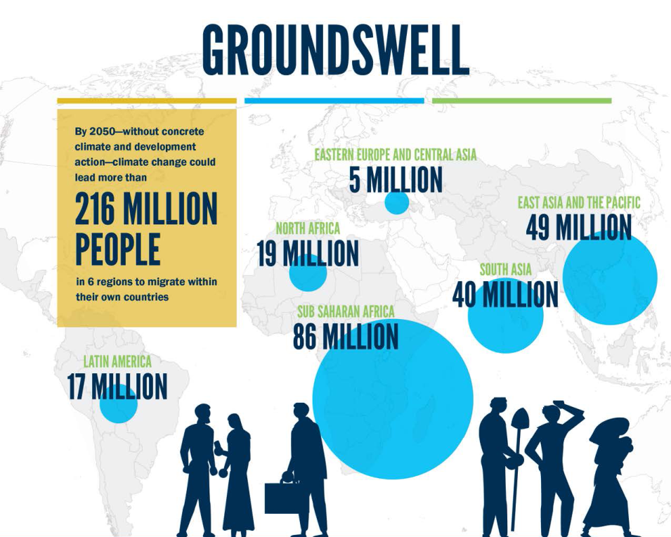
As de Sherbinin points out, anyone interested in scrutinizing the report’s results should note that anytime there are projections of future social dynamics in a complex socio-ecological system there are going to be big uncertainties. “Climate projections have well-documented uncertainties, which are carefully qualified in Intergovernmental Panel on Climate Change reports,” he said. “We take climate projections two steps further: we use sectoral impact models of crop production and water availability that use the climate projections as inputs. Then we calibrate the population gravity model by assessing the sensitivity of past shifts in population distribution to these sectoral impacts and project future shifts in population on the assumption that the population will maintain a similar sensitivity to climate impacts out to the year 2050. This is a big assumption.”
Such uncertainties can be addressed, at least in part, by running multiple scenarios, a common practice in the climate literature. Nevertheless, de Sherbinin advises that Groundswell data should be understood as plausible future scenarios with high levels of underlying uncertainty. An additional uncertainty is the fact that future climate adaptation measures are explicitly not taken into account.
“They might be best thought of as one input among many that a decision-maker might use to inform policies and programs [on] where to invest climate adaptation funding, how much infrastructure to build out in anticipation of population growth, [and forecasts of] where people may be moving towards areas of vulnerability, such as the coastal zone, etc.,” he said.
To that end, de Sherbinin said he could foresee researchers “using the data in conjunction with remotely sensed and other spatial data to understand potential future trends in climate mobility in given geographical zones, such as the low elevation coastal zone, mountainous areas, forest lands, and the like.”
He also suggested that national governments may want to use these data in conjunction with other data to better understand future climate impacts on population distribution.
SEDAC, which is operated by CIESIN, is the NASA Earth Observing System Data and Information System (EOSDIS) Distributed Active Archive Center (DAAC) responsible for archiving and distributing socioeconomic data within the EOSDIS collection. As such, it offers three additional population-focused datasets that, according to de Sherbinin, may serve as a complement to Groundswell data:
- Global One-Eighth Degree Population Base Year and Projection Grids Based on the SSPs, v1.01 (2000 – 2100)
Provides global urban, rural, and total population base year and projection grids based on SSP data at a resolution of one-eighth degree (unlike Groundswell, which uses two SSPs, these provide scenarios according to all five SSPs)
- Global 1-km Downscaled Population Base Year and Projection Grids Based on the SSPs, v1.01 (2000 – 2100)
Provides global urban, rural, and total population base year and projection grids based on the SSPs at a resolution of 1-kilometer (this is essentially a higher resolution version of the dataset above)
- Global Estimated Net Migration Grids By Decade, v1 (1970 – 2000)
Provides estimates of net-migration (in-migration minus out-migration) per one-kilometer grid cell on a decadal basis for the 1970s, 1980s, and 1990s
The Groundswell dataset’s projections of future population distributions with and without climate impacts, along with future estimates of climate migration, have already been used by The World Bank for country consultations related to development planning. Further, using the dataset to anticipate the potential scale of population shifts as a result of climate impacts can be useful to the humanitarian assistance community, which uses forecasts of displacement to locate aid and social services; urban planners, who endeavor to understand the magnitude of future flows from rural areas; and policymakers, who use “what if” scenarios based on alternative futures to anticipate the effects of proposed policies.
Of course, the Groundswell dataset’s projections of future population distributions are just that, projections; how internal climate migration actually plays out during the next half-century will, according to The World Bank, “depend on our collective action on climate change and development in the next few years.” Slowing that migration, the The World Bank says, will require urgent “action to reduce greenhouse gas emissions to reduce the climate pressures that drive internal climate migration.”
The World Bank acknowledges that not all migration can be prevented. However, if well-managed, such shifts in the distribution of populations can become part of an effective adaptation strategy, allowing people to rise out of poverty and build resilient livelihoods. Having the Groundswell dataset freely and openly available from NASA’s SEDAC can benefit the development and management of any internal climate migration plan.
How to Access the Data
The Groundswell Spatial Population and Migration Projections at One-Eighth Degree According to SSPs and RCPs, v1 (2010 – 2050) dataset is available through Earthdata Search as well as from the SEDAC website. At SEDAC, users also will find several maps of Groundswell Projections 1/8th degree SSPs and RCPs (2030, 2050) for Africa, South Asia, and East Asia.
Additional Information
- Groundswell data are available in GeoPackage (GPKG) and Esri File Geodatabase (GDB) formats for each of the 112 countries modeled.
- The countries are listed in Table 5 of the product documentation (see page 24) and each file includes the International Organization for Standards three-character alphabetic code (ISO3 code) listed in the table. The data dictionary includes field names and descriptors for 204 variables found in each file. This is packaged with each download as a separate Excel file.
- Each downloadable file is a compressed zip file containing the GPKG or GDB file, a Microsoft Excel file (XLSX) data dictionary, and PDF documentation.
