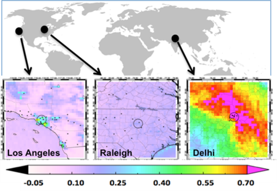
Map showing particulate matter (PM) levels at 3 pilot project cities.
Image Caption

Prakash Doraiswamy, Research Triangle Institute

The term particulate matter (PM) refers to particles of solids and liquids, also known as aerosols, that are suspended in the air. Scientists and health officials are especially interested in PM with diameters less than 2.5 micrometers (PM2.5) near Earth's surface because particles of this size can be especially effective at reducing air quality and be harmful to human health.

Due to their ability to scatter and absorb sunlight, aerosols can be effectively observed by satellites. However, satellites tend to be most sensitive to the integrated light scattering and absorption over the entire depth of the atmosphere, deriving a quantity known as aerosol optical depth (AOD). While AOD can sometimes be used to infer the PM2.5 concentration at the surface, it is not a surface measurement. Since it is far too expensive to provide reference surface measurements everywhere on Earth we must rely on satellites to help fill in the gaps.

The objective of the Air Quality Citizen Science project is to add value to AOD measurements obtained by NASA's suite of orbiting satellites. Citizen scientists are helping to create a network of high quality, low-cost sensors (manufactured by PurpleAir) in three regions with varying levels of air quality: Los Angeles, California; Raleigh, North Carolina; and Delhi, India. The citizen scientists deploy and maintain the sensors and transmit the data that is collected to a central database. This data will help NASA validate and interpret the current state of satellite-derived AOD estimates.

In addition to helping NASA missions, citizen scientists also have the opportunity to use the data to understand their own local air quality. Participants attend workshops where they learn to analyze the data and see how those data are helping NASA. With the participation of local citizen scientists, such sensor networks can provide a cost-effective and sustainable method of data collection, while enhancing NASA's mission to develop the next generation of scientists.


Update October 2019

Air Quality Citizen Science has developed a comprehensive sensor installation toolkit which includes step-by-step instructions, infographics, and guidance on sensor placement. The toolkit is currently being updated to include the basics of remote satellite data, as well as guidelines for how citizen scientists can engage with the project.

As of date, the project has deployed nearly 180 PurpleAir sensors in Southern California, including the sensors deployed during the feasibility study. Generally located northwest and southeast of Los Angeles, these sensors are collecting PM2.5 data and report approximately every two minutes to an open-access database. Two citizen-science workshops were held in Southern California region where volunteers received basic training on sensor installation and sensor data analysis and interpretation.
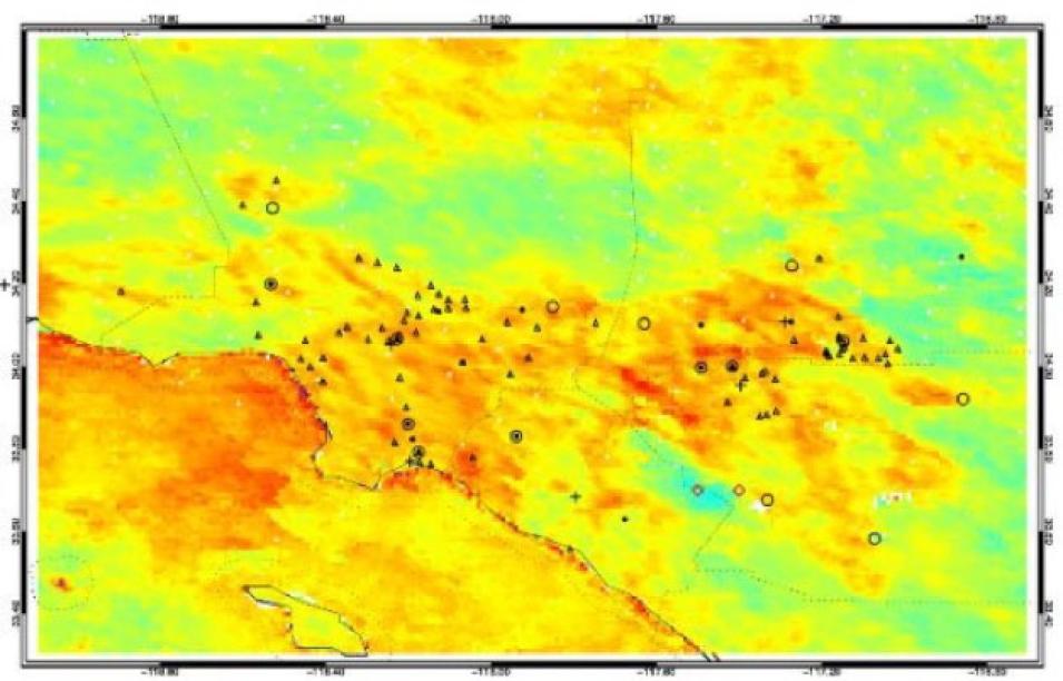
Map of Los Angeles, CA showing PurpleAir sensor deployment.
Image Caption

Los Angeles, California-area image showing an overlay of AOD gradient on sensor locations.

In addition to network deployment, the project is performing field evaluation of the sensors by collocating them next to the Federal Equivalent Method (FEM) monitors at two South Coast Air Quality Management District air monitoring stations, one in Riverside, and the other in downtown Los Angeles. The initial collocated sensor data from our feasibility study are being used to explore the development of suitable machine learning techniques for correcting sensor response.

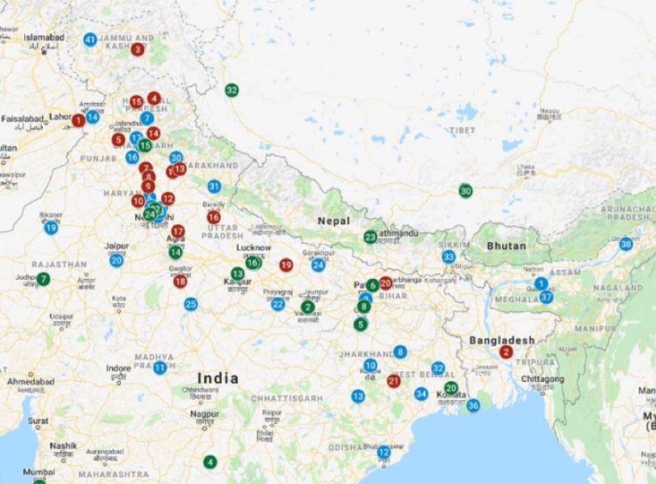
In year two, the team will deploy sensors in networks near Raleigh, NC and along the Indo-Gangetic Plain in North India. In North Carolina, the team is collaborating with the North Carolina Museum of Natural Sciences (NCMNS) to recruit citizen scientists in that region. Citizen scientist recruitment is underway in India and sensor deployment is planned for early 2020. At least 46 sites have already been identified for potential sensor deployment.

Map of northern India showing possible locations for low cost sensors.
Image Caption

Tentative locations identified in India for PurpleAir sensor deployment. Blue indicates locations with contacts identified, red indicates additional locations desired, and green indicates existing regulatory monitors.


Visit the Air Quality Citizen Science site for updates and more information. Read more about NASA's Citizen Science for Earth Systems Program (CSESP).

Presentations and Publications

Gupta, P., Doraiswamy, P., Levy, R., Pikelnaya, O., Maibach, J., Feenstra, B., Polidori, A., Kiros, F., & Mills, K.C. (2018). Impact of California Fires on Local and Regional Air Quality: The Role of a Low-Cost Sensor Network and Satellite Observations. Geohealth 2(6): 172-181. doi:10.1029/2018GH000136

Doraiswamy, P., et al. (2018, June). Using Citizen Scientists and Low-Cost Sensors to Understand Local Air Quality and Improve Satellite Estimates – Lessons Learned. Paper presented at Air & Waste Management Association’s 111th Conference, Hartford, CT.

Doraiswamy, P., et al. (2018, November). Feasibility of Using Low-Cost PM2.5 Sensors for Air Quality Monitoring by Citizen Scientists. Paper presented at the 10th Better Air Quality (BAQ) conference, Kuching, Malaysia.

Gupta P., et al. (2018, November). Role of low-cost sensors and satellite observations in quantifying the impact of fires on local and regional air quality. Paper presented at DST-UKIERI Workshop on ‘Emerging Sensor Technologies and Data Analytics for Air Quality Monitoring’ held at Indian Institute of Technology, New Delhi, India.

Gupta P., et al. (2018). Air Quality, Citizen Science and Capacity Building Powered by Earth Observations. Paper presented at the Indian Institute of Technology, Gandhinagar, India.

Gupta P., et al. (2018). Integration of satellite observations with low-cost air quality monitors: A data science approach to monitor air quality. American Geophysical Union, Fall Meeting.

Gupta P., et al. (2018, November). Impact of California Fires on Local and Regional Air Quality: The Role of a Low-Cost Sensor Network and Satellite Observations. Indian Aerosol Science and Technology Association, Biennial Conference.

Doraiswamy, P., et al. (2018). Engaging Citizen Scientists and Low-Cost Sensors to Understand Local Air Quality. Paper # IN23A-0763, poster presentation at American Geophysical Union, Fall Meeting.

Gupta et al. (2019, June). Integration of satellite observations with low-cost air quality monitors: A Citizen Science Project. Paper presented at the American Meteorological Society annual meeting.

Mills, K., et al. (2019, March). Citizen Science and Low-Cost PM2.5 Sensors for Air Quality Monitoring – Lessons Learned for Engagement. Panel Presentation at the Citizen Science Association Conference, Raleigh, NC.

Gupta et al. (2019, March). Integration of satellite observations with low-cost air quality monitors: A Citizen Science Project. Presented at the Citizen Science Data Working Group (CSDWG) meeting, part of the NASA Earth Sciences Data Working Group, Annapolis, MD.