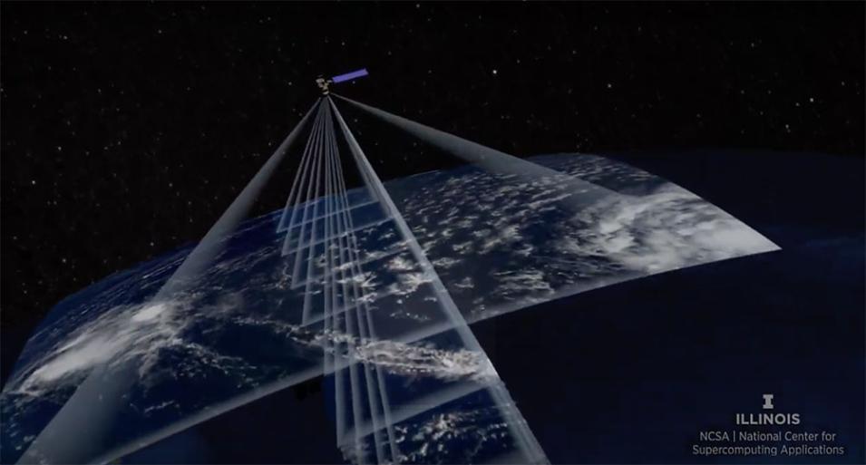
Combining data from Terra’s individual instruments for scientific purposes, however, is difficult. Individual instrument data are stored in different locations with different file formats, granularities, and projections. Additionally, the large volume of Terra data (now more than 1 petabyte and increasing at a rate of close to 2 terabytes a day), makes processing for analysis extremely time consuming.
The ACCESS to Terra Data Fusion Products project combines Terra observations from different instruments and enables scientists to derive new Terra products to examine changes to Earth and the planet’s atmosphere over the course of the Terra mission.
Recent Achievements
Over the past year, project PI Larry Di Girolamo generated and validated the mission-wide Terra Basic Fusion (BF) product. The BF product is currently staged at UIUC’s National Center for Supercomputing Applications as well as on Amazon Web Services (AWS) Glacier. A small subsample is publicly available through the Registry of Open Data on AWS. Dr. Di Girolamo also developed a public toolbox that efficiently generates Terra data fusion products that can be used to address a wide range of Earth science questions.
The Climate Marble product, for example, uses fused Terra data to visualize Earth and its atmosphere from 2000 to 2020 and uses change detection to measure trends. An early example using only Terra’s MISR instrument for the first 15 years of the mission to identify statistically significant trends in the color and spatial texture of Earth as viewed from multiple directions was published in IEEE Transactions on Geoscience and Remote Sensing (doi:10.1109/TGRS.2016.2538723). Dr. Di Girolamo has extended the project to include all five instruments.
In light of the ongoing pandemic, the project team is updating the Terra Level 1 analysis of current data to look for anomalies caused by the novel coronavirus and COVID-19, the disease caused by the virus. These anomalies include changes in pollution, contrails, and other features detected by Terra’s instruments in the Level 1 radiances.
Data fusion may also facilitate new research into air pollution, smoke from wildfires, clouds and aerosols, ocean biology, agriculture and land use, vegetation dynamics, hydrology, Earth’s radiation budget, and other Earth science fields that have traditionally used Terra data.
Publications (listed alphabetically)
Dutta, S., Di Girolamo, L., Dey, S., Zhan, Y., Moroney, C.M. & Zhao, G. (2020). “The reduction in near-global cloud cover after correcting for biases caused by finite resolution measurement.” Geophysical Research Letters, 47(23), e2020GL090313 [doi:10.1029/2020GL090313].
Fu, D. (2018). “Examination of the behavior of MODIS-retrieved cloud droplet effective radius through MISR-MODIS data fusion.” Master of Science (M.Sc.) Thesis, University of Illinois at Urbana-Champaign.
Fu, D., Di Girolamo, L., Liang, L. & Zhao, G. (2019). “Regional biases in Moderate Resolution Imaging Spectroradiometer (MODIS) marine liquid water cloud drop effective radius deduced through fusion with Multi-angle Imaging SpectroRadiometer (MISR).” Journal of Geophysical Research, Atmospheres, 124(23): 13182-13196 [doi:10.1029/2019JD031063].
Wang, Y., Hioki, S., Yang, P., King, M.D., Di Girolamo, L., Fu, D. & Baum, B.A. (2018). “Inference of an optimal ice particle model through latitudinal analysis of MISR and MODIS data.” Remote Sensing, 10(12): 1981 [doi:10.3390/rs10121981].
Wang, Y., Yang, P., Hioki, S., King, M.D., Baum, B.A., Di Girolamo, L. & Fu, D. (2019). “Ice cloud optical thickness, effective radius, and ice water path inferred from fused MISR and MODIS measurements based on a pixel-level optimal ice particle roughness model.” Journal of Geophysical Research, Atmospheres, 124(22): 12126-12140 [doi:10.1029/2019JD030457].
Zhan, Y., Di Girolamo L., Davies, R. & Moroney, C. (2018). “Instantaneous top-of-atmosphere albedo comparison between CERES and MISR over the Arctic.” Remote Sensing, 10(12): 1882 [doi:10.3390/rs10121882].
Zhao, G., Di Girolamo, L., Diner, D.J., Bruegge, C.J., Mueller, K. & Wu, D.L. (2016). “Regional changes in Earth’s color and texture as observed from space over a 15-year period.” IEEE Transactions on Geoscience and Remote Sensing, 54(7): 4240-4249 [doi:10.1109/TGRS.2016.2538723].
Zhao, G., Yang, M., Gao, Y., Zhan, Y., Lee, H-K & Di Girolamo, L. (2020). “PYTAF: a python tool for spatially resampling Earth observation data. Earth Science Informatics.” Earth Science Informatics (2020) [doi:10.1007/s12145-020-00461-w].
