NASA's Global Imagery Browse Services (GIBS) are designed to deliver global, full-resolution satellite imagery to users in a highly responsive manner, enabling interactive exploration of Earth. GIBS provides access through five mechanisms:

  • An Open Geospatial Consortium (OGC) Web Map Tile Service (WMTS) that supports key-value-pair and Representational State Transfer (REST)ful tiled requests
  • An OGC Web Map Service (WMS) that supports a key-value-pair non-tiled requests
  • A Tiled Web Map Service (TWMS), an unofficial extension to the OGC WMS, that supports key-value-pair tiled requests that match the exact geographic tile boundaries
  • Script-level access through the Geospatial Data Abstraction Library (GDAL)

Access to GIBS via the protocols above is explained in the links below. In addition, source code for the GIBS tiled imagery server and tiled imagery storage format is also available.

Explore GIBS

Visually explore the past and present of our dynamic planet through NASA's GIBS. GIBS provides quick access to over 1,000 satellite imagery products, covering every part of the world. Most imagery is updated daily—available within a few hours after satellite observation, and some products span almost 30 years. The satellite imagery can be rendered in your own web client or GIS application.

NASA Global, Full Resolution Imagery

NASA GIBS provides full-resolution visual representations of NASA Earth science data in a free, open, and interoperable manner. Through responsive and highly available web services, it enables interactive exploration of data to support a wide range of applications including scientific research, applied sciences, natural hazard monitoring, and outreach.
Quick and Easy Access to Imagery

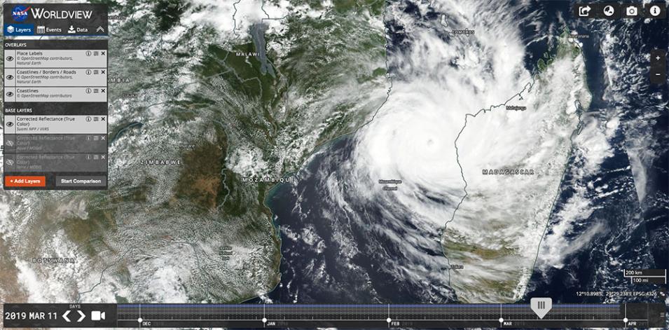
Tropical Cyclone Idai on 11 March 2019 (Suomi-NPP/VIIRS)
Image Caption

Tropical Cyclone Idai in the Mozambique Channel. Image captured by the VIIRS instrument aboard the joint NASA/NOAA Suomi NPP satellite on 11 March 2019, shown in Worldview. Credit: NASA Worldview.

Quickly access satellite imagery of every part of the world in near real-time. Many products are available within 3-5 hours of being observed. The imagery archive is also being expanded to include more historical products along with those from newly-launched sensors. Visit Worldview to see available imagery from GIBS.

Your Client, Your Application

Imagery are available in a variety of standards-based web services to plug into your own web clients and GIS applications, allowing users to tailor it to their needs and the needs of their end users.

Features

Access imagery through standards-based web services and formats:

  • Web Map Tile Service (WMTS)
  • Tiled Web Map Service (TWMS)
  • Web Map Service (WMS)
  • Geospatial Data Abstraction Library (GDAL)

Imagery is provided in several map projections:

  • Geographic / Equirectangular (EPSG:4326)
  • Web Mercator (EPSG:3857)
  • Arctic Polar Stereographic (EPSG:3413)
  • Antarctic Polar Stereographic (EPSG:3031)

View GIBS in action in Worldview, Worldview Snapshots, and Earthdata Search.

Data Use Policy and Acknowledgements

NASA supports an open data policy. We ask that users who make use of GIBS in their clients or when referencing it in written or oral presentations to add the following acknowledgment:

We acknowledge the use of imagery provided by services from NASA's Global Imagery Browse Services (GIBS), part of NASA's Earth Science Data and Information System (ESDIS).

Contact

Please contact us with questions or problems at Earthdata Support and visit the Earthdata Forum to view frequently asked questions and answers provided by our community of experts.

To stay up to date with new capabilities or changes to existing services, follow the Earthdata blog or subscribe to our mailing list by sending an email to eosdis-gibs-announce-join@lists.nasa.gov to join (no subject or text in the body is needed).