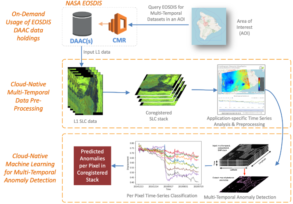
While individual subject matter volcano, flood, and landslide experts will provide their own in-depth analysis for actual events, the value of an automated approach is to automatically process Level 3 time series data covering a broad number of AOIs and then apply machine learning (ML) for detecting potential anomalies that otherwise were not actively being monitored. Any anomalies that pass thresholds can be used to notify these experts for their in-depth analysis.
The team’s NASA Earth Science Technology Office (ESTO) Advanced Information System Technology (AIST) AIST-2011 and AIST-2014 efforts towards an Advanced Rapid Imaging and Analysis (ARIA) data system successfully demonstrated the capability to automate high-volume SAR image analysis in a cloud computing environment. A limiting factor, however, has been the continued need for expert analysis for detection of features in the Level 2 data products as well as transients in the Level 3 time-series data products.
Decision support products are most useful if they are generated rapidly and with simplified information (e.g., damaged/not damaged, flooded/not flooded, etc.). This requires change detection-based approaches utilizing before and after event scenes. These change detection approaches are often processed with threshold values set on the underlying SAR measurement values of either amplitude or coherence. The steps in change detection, which require a human-in-the-loop, have become a bottleneck for rapid and reliable exploitation of geodetic SAR data for both long-term monitoring and event rapid response. Automating these time domain-based feature detection procedures is challenging because of the complexity of processing, the need to process large temporally co-registered data stacks, and the human expertise needed to assess the time domain signals.
ML approaches for Earth science data have typically been applied to single scene feature detection. In the AIST-2014 effort, for example, the team prototyped automated classification of phase unwrapping features in processed Level 2 interferograms from the ESA (European Space Agency) Sentinel-1A/B satellite data streams. For change detection techniques, however, most methods have focused on paired before/after observations.
With the greater availability of low-latency and global multi-temporal remote sensing data, opportunities exist to exploit detection of time-dependent features of highly temporal Earth science observations. Multi-temporal spatial prediction techniques that leverage long-term historical observations can yield more accurate and more interpretable predictions than the more commonly used pair-wise change detection techniques.
This project leveraged a science data system (SDS) approach to automated processing by exploiting Sentinel-1A/B SAR data available through NASA’s Alaska Satellite Facility Distributed Active Archive Center (ASF DAAC) in preparation for the upcoming NASA-Indian Space Research Organization (ISRO) SAR (NISAR) mission. NASA’s provision of the complete ESA Sentinel-1 SAR data archive through ASF DAAC is by agreement between the U.S. State Department and the European Commission (EC).
Sentinel 1-A/B data were used to derive SAR amplitude and displacement signals and process to Level 3 time series data in order to apply ML for automated detection of potential anomalies in the multi-temporal processed SAR data. This work demonstrated real science value in example use cases such as automated landslide detection, automated volcanic uplift early detection, and/or automated detection of pre-event time-series patterns versus co-event flood detection.
Publications and Presentations (listed alphabetically)
Hua, H., Owen, S., Yun, S., Fielding, E., Manipon, G., Linick, J., Karim, M., Bue, B.,Sacco, G., Malarout, N., Bekaert, D., Agram, P., Lucas, M. & Dang, L. (2019). “On the Use of Cloud, Algorithm Catalogs, and Machine Learning for SAR-Based Hazards Monitoring.” 2019 IEEE Geoscience and Remote Sensing Society (IGARSS) Meeting, Yokohama, Japan. Session TH3.R4, “End-to-End New Observing Strategies for Disaster and Environment III,” presented 1 August 2019. (This paper also was accepted for IGARSS 2020 as “Anomaly Detection and On-Demand Algorithm-Based Analysis Center Framework for Multi-Temporal SAR ARDs”.)
Hua, H., Manipon, G., Linick, J., Karim, M., Malarout, N., Owen, S., Yun, S., Agram, P., Sacco, G., Bue, B., Bekaert, D., Fielding, E., Lundgren, P., Liu, Z., Farr, T., Webb, F., Rosen, P. & Simons, M. (2018) “Lessons Learned from Getting Ready For NISAR: Large-Scale Science Data Systems with Machine Learning and Disasters Response from the Cloud.” 2018 American Geophysical Union (AGU) Fall Meeting, Washington D.C. Presented 14 December 2018.
Yun, S., Jung, J., Lin, Y-N, Stephenson, O., Bhardwaj, A., Ulloa, N.I., Gebrehiwot, A., Chin, S.T., Jing, C.T.W., Owen, S.E., Hua, H., Manipon, G., Agram, P., Liang, C., Fielding, E.J., Hill, E., Rosen, P., Webb, F. & Simons, M. (2019). “Future of Rapid Disaster Mapping with SAR Observations.” 2019 AGU Fall Meeting, San Francisco, CA. Presented 10 December 2019.
