Synthetic Aperture Radar (SAR)

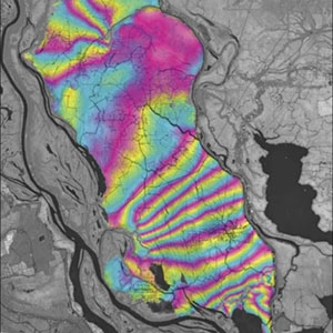
Synthetic aperture radar, or SAR, uses the microwave region of the electromagnetic spectrum. SAR can penetrate cloud cover and “see through” darkness and weather, allowing a unique view of flood inundation, land cover changes, and modifications of Earth’s surface from landslides, earthquakes, and background tectonic motion. NASA’s home for SAR data and imagery is the Alaska Satellite Facility Distributed Active Archive Center (ASF DAAC). 

You Might Also Be Interested In

Filter By

Content type
Over 200 subglacial lakes have been discovered underneath the ice of Antarctica, some of which are marked with white and black with dots on this map.
Article
A researcher checks the calibration of a ground-mounted Global Positioning System (GPS) station on Mount St. Helens.
Article
Lascar volcano in Chile is the most active volcano in the central Andes, with several eruptions occurring during the 1990s.
Article