Essential variables (EV) are variables known to be critical for observing and monitoring a given facet of the Earth system. Many professional organizations—the World Meteorological Organization, the United Nations Environment Program, the International Science Council, and the Group on Earth Observations (GEO) to name a few—have sponsored the collaboration of institutions across the world to identify essential variables in their respective fields of study. These include oceanography, climatology, biodiversity studies, and geodiversity. Having a common set of accurate and sustained measurements with standards for data collection and dissemination ensures the usability of data across multiple platforms and agencies.
Consistent measurements of EVs, as identified by subject matter experts, need to be maintained over time to accurately serve as a means to monitor and assess change to Earth systems, including the atmosphere, biosphere, land, and ocean. Expert panels, consisting of scientific and technical individuals from academia, international space agencies (like NASA and the European Space Agency), government organizations, and non-governmental organizations review the requirements for EV observations, including temporal frequency and spatial resolution, and then match these requirements to the capabilities of existing instruments (from moorings to satellites). Many of NASA’s current missions collect data that meet EV requirements.
Climate
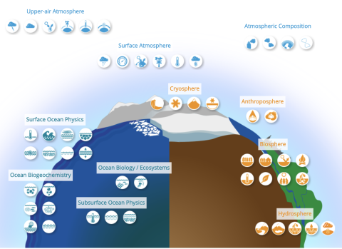
The Global Climate Observing System (GCOS) has identified a set of 54 atmosphere, land, and ocean variables as Essential Climate Variables (ECVs). The atmosphere ECVs cover both surface and upper-air atmosphere, and atmospheric composition. Land ECVs cover the hydrosphere, cryosphere, biosphere, and anthroposphere. Ocean ECVs cover physical, biogeochemical, and biological/ecosystems disciplines.
In order to fully understand Earth’s integrated system and the interactions therein, among various elements that affect climate, the ECVs are accompanied by descriptions of the measurement requirements for spatial and time scales. Also noted are the types of observing platforms currently employed, existing capability gaps, and future observing opportunities. ECVs are periodically reviewed and updated; these updates ensure that newly feasible variables (ones that technology has now made practical) are added as appropriate. Currently, GCOS is in the process of refining ECV requirements and vetting new ECVs proposed through broad community engagement.
Ocean
The ocean covers 70 percent of Earth's surface. It is home to millions of species, plays a major role in the Earth's weather and climate, and affects all of humanity’s water and food supply. Having consistent and reliable measurements of ocean variables is integral to understanding the role the ocean plays in Earth’s climate system. These measurements also help us understand the connection between the ocean and other Earth system elements such as the atmosphere, biosphere, hydrosphere, cryosphere, and anthroposphere.
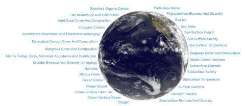
According to United Nations Educational, Scientific and Cultural Organization’s (UNESCO) Global Ocean Observing System (GOOS), critical ocean processes “… include, among others, those linked to ocean circulation; the distribution and transport of heat, salt and other water properties; [and] exchanges of heat, momentum, freshwater, and gasses between the different parts of the climate system.” GOOS has additional information on Essential Ocean Variables (EOVs), with details on the sub-variables, the temporal and spatial scales, the types of observing instruments, and future observing opportunities.
Biodiversity
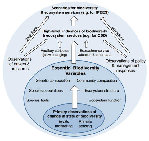
Biodiversity is the variety of life on earth, including the variation of genes, species, and ecosystems. Current estimates for species, for example, suggest that Earth is home to at least 2 million to 6 billion species (Larsen, et al., 2017). These species and their associated ecosystems provide humans with a variety of critical “ecosystem services” including food, fiber, clean water, pollination, flood protection, recreation, and many more. However, ocean pollution and overfishing, land use change such as from agriculture and urbanization, and climate change, are among the causes of a rapid loss of biodiversity. Essential Biodiversity Variables (EBVs) capture the essential dimensions of biodiversity so that the state of biodiversity can be monitored and understood.
The Group on Earth Observations Biodiversity Observation Network (GEO BON) has identified six classes of EBVs—one for genetics, two for species, and three for communities and ecosystems, and several EBVs have initially been identified within each class. To help enable measuring these variables GEO BON facilitates the development of national and regional Biodiversity Observation Networks that actively collect and process the data. These data are then available to decision and policy makers.
NASA has numerous datasets that can be used in assessing EBVs. The Biological Diversity Toolkit provides direct links to those datasets, related webinars on using the data, and data recipes and tutorials. Forthcoming, a Biological Diversity and Ecological Forecasting Data Pathfinder, geared for new users, will provide direct links to commonly used datasets and links to tools for visualizing and analyzing the data. Read Harnessing Remote Sensing Data for Biological and Ecological Research to see how NASA data are being used in research applications.
Geodiversity
The ECVs, EOVs, and EBVs encompass a wealth of information; however, they do not take into consideration the abiotic surface and subsurface geology, geomorphology, and pedology (soil science) of an area. Essential Geodiversity Variables (EGV) are important as they play a significant role in the availability of natural resources and often underpin the other essential variable frameworks.
Geodiversity has significant effects on biodiversity. Geodiversity directly influences the resources available for species, including energy, nutrients and water. Geodiversity also plays a major role in the carbon, nitrogen, phosphorus and sulfur cycles and their interactions with other Earth systems. Remotely sensed data measure many of these essential geodiversity variables and so can help explain the relationships between geodiversity and biodiversity, as well as connections between geodiversity and the other EVs.
For example, simply mapping the distribution of a species is difficult as direct detection through remote sensing for many taxa is impossible. Scientists often rely on geodiversity variables that are known to constrain where a species is likely to survive and thrive, as a proxy variable to estimate likely distribution. They may also use these variables to model suitable habitat by relating known species’ occurrences points (often presence-only) to the surrounding abiotic predictor variables (such as the EGVs). Those models can then be used to map habitat suitability for that species in similar environmental conditions.
Datasets from NASA that can be obtained to assess EGVs are topography, soil moisture, precipitation, groundwater, spectral reflectance, mineralogy, and much more. For a full listing of satellite-based remotely sensed datasets, view the Geodiversity Data Products Table.
Agriculture
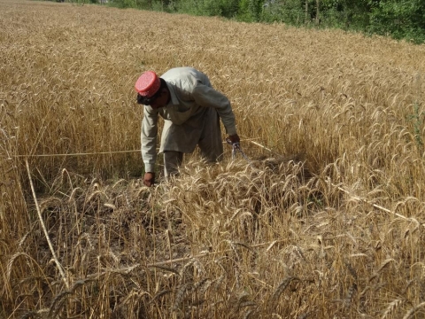
GEO's Global Agricultural Monitoring (GEOGLAM) is in the process of developing Essential Agricultural Variables (EAV) to define the minimum set of variables in order to reinforce the international community's capacity to produce and distribute relevant, timely, and accurate information on agricultural land use and production at national, regional, and global scales.The EAVs considered include vegetation and chlorophyll indices, above ground biomass, surface water mapping, evapotranspiration, land cover, and many more.


