"Crucial." That's how Gordon Seymour, Geographic Information Systems (GIS) and Wildfire Data Technician with Canada's Department of Environment and Climate Change (ECC), describes the value of NASA's Fire Information for Resource Management System (FIRMS) to his work in the South Slave region of Canada's Northwest Territories (NWT).
FIRMS provides rapid access to satellite imagery, information about active fires and hotspots, and related products to assist users in identifying the location, extent, and intensity of wildfire activity. FIRMS tools and applications provide geospatial data, products, and services to support the broader fire management community and to inform the public.
"Having access to [FIRMS] has become an integral part of our work," said Seymour, who's been using FIRMS since the late-2000s. "Because we have such a large territory to cover and few individuals, any kind of technological assistance we can garner to help us keep an eye on things is most welcome. Having FIRMS hotspot detections is absolutely crucial for us to have in our toolbox."
Wildfire in the Northwest Territories

A "large territory to cover" is putting it mildly. Canada's Northwest Territories span more than 1.3 million square kilometers (more than 500,000 square miles) and has an estimated population of 45,000. Approximately 46% of the NWT (~614,000 square kilometers) is forested, and 112,600 square kilometers (approximately 70,000 square miles) of that forestland lies within the boundaries of the South Slave Administrative Region.
"If I were to go out on a detection patrol, usually in a small aircraft, a round trip from my community of Fort Smith to the southeast corner of our region is about 700 miles," Seymour said. "We often don't go that far, but occasionally we'll need to go and have a look to confirm detections that we've noticed."
FIRMS hotspot detection data make this task easier.
"Fire detection is one of the primary things we use FIRMS for," he said. "Basically, we'll go out and physically confirm that a notification we've received is indeed a fire, and ensure they are not possibly false hits."
The vast majority of the fires that start in the NWT are caused by lightning and, in general, the fire season in the South Slave Region runs from around May 1 to October 1. However, Seymour notes that recent fire seasons have started earlier and lasted longer, with active fire activity occurring until the end of October, when snow stays on the ground and finally ends the season.
In addition to lasting longer, fire seasons in the NWT are getting more intense. In fact, the 2023 fire season was particularly noteworthy. In mid-August, there were 236 active fires in the NWT and the threat they posed to communities led the government to declare a territory-wide state of emergency, prompting the biggest evacuation operation in NWT history.
"[2023 was] an unprecedented fire season, certainly in the 40 years that I've lived in the Northwest Territories," he said. "I've never seen anything like it, both in terms of the general extreme drought conditions and the actual fire weather we experienced in those conditions."
A busy fire season can make confirming a deluge of hotspot detections difficult, said Seymour, who noted that in 2023, there were moments when he and his colleagues were receiving 20 to 30 fire notifications an hour. Data from FIRMS helped Seymour and his colleagues decide which fires to prioritize.
Using FIRMS in the Northwest Territories
"The first thing we'll often do is pull up our values database, which shows the locations of structures (e.g., cabins), industrial facilities (e.g., mines), etc. and overlay it with Moderate Resolution Imaging Spectroradiometer (MODIS) or Visible Infrared Imaging Radiometer Suite (VIIRS) detections," he said. "If we receive a notification that's close to a structure, we will prioritize that location and go have a look and assess the situation."
If Seymour and his fellow team members can't immediately get out to confirm a notification, they'll sometimes turn to FIRMS detection data for help.
"If we notice there's two more hits beside the first in the next day, then there's a good chance that there's an active fire," Seymour said. "We'll then often use [satellite] imagery when available from Landsat or Sentinel-2, whose higher spatial resolution gives us a better chance of seeing smoke. If we see smoke on the imagery at the same location, then it's a pretty sure bet it’s an active fire."
Such use of the FIRMS Fire Map and data not only makes Seymour and his department more efficient, it helps them make the most of their often-limited resources.
"Up here, we don't have a lot of roads going everywhere, so often the only way to go out and see things on the ground is to actually fly out there. More often than not that requires a helicopter, and aviation costs have gone right through the roof," Seymour said. "They've probably more than doubled in the last 10 years. So, having tools [like FIRMS] really helps us keep costs down."
FIRMS Foundations
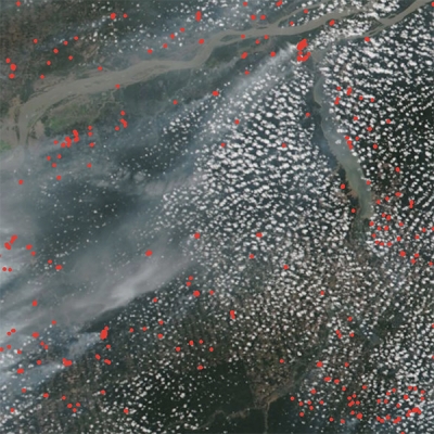
FIRMS' active fire data are derived from the MODIS and VIIRS instruments, both of which can detect radiated energy from their respective orbits approximately 440 and 515 miles (705 and 830 kilometers) above Earth's surface.
MODIS flies aboard NASA's Terra and Aqua satellites, and the Fire and Thermal Anomalies product generated from it is the foundation of FIRMS active fire products. When MODIS detects a thermal anomaly, which could indicate a wildfire or any significant source of heat, a computer algorithm identifies the center of the one square-kilometer area in which the anomaly is detected. This location is plotted and available to fire crews and wildland managers within three hours of observation, providing an approximate location of a potential wildfire or hotspot.
VIIRS flies aboard the joint NASA-NOAA Suomi National Polar-orbiting Partnership (Suomi NPP) and the Joint Polar Satellite System’s (JPSS) NOAA-20 and -21 satellites. The VIIRS I-band (375 meter) Active Fire product is based on the MODIS Fire and Thermal Anomalies product, which means there is good agreement between the two products. However, VIIRS provides better response for smaller fires and improved mapping of large fire perimeters. Further, the VIIRS 375 m product shows a better response in nighttime observations, when fire activity normally subsides.

Globally, FIRMS data products are available in near real-time (NRT), which means within 3 hours of a satellite observation. For the United States and Canada, FIRMS provides active fire detections in real-time (meaning within the hour) and ultra real-time (within 5 minutes). FIRMS also offers:
- A NRT Landsat Fire and Thermal Anomaly active fire product generated with data from the Operational Land Imager (OLI) instrument aboard Landsat 8 and the Operational Land Imager-2 (OLI-2) aboard Landsat 9. These data are available in approximately 30 minutes after a satellite observation and at 30-meter spatial resolution, which is much higher resolution than MODIS and VIIRS products. (Note: This product currently covers only the continental United States and most of Canada and Mexico.)
- A false color composite imagery layer from the Harmonized Landsat and Sentinel-2 (HLS) project. This layer is created with data from the Landsat OLI and OLI-2 instruments and the Multi-Spectral Instrument (MSI) aboard the ESA (European Space Agency) Sentinel-2A and -2B satellites. This product, which is available approximately 2 to 4 days after a satellite observation, aids active fire detection by providing imagery of active fire fronts at the relatively high spatial resolution of 30 meters along with improved delineation of burned areas.
- Geostationary active fire data is available from the Advanced Baseline Imager (ABI) aboard NOAA's GOES-16 and -18 satellites, the Spinning Enhanced Visible and Infra-Red Imager (SEVIRI) aboard ESA's Meteosat-9 and -11 satellites, and the Advanced Himawari Imager (AHI) aboard the JAXA (Japan Aerospace Exploration Agency) Himawari-8 satellite. These instruments provide data with 2 kilometer per pixel spatial resolution at 10- to 15-minute intervals, so they can detect more fire events and capture their growth and change. However, the spatial resolution of geostationary satellite data is coarser than MODIS data (and therefore less sensitive to small fires), and the pixel size expands as one moves from the center of the image toward the poles. (Note: Users can learn more about the characteristics of geostationary data in FIRMS in the FAQs on the FIRMS website.)
Using FIRMS in the NWT
In addition to the real-time fire detection data available from the FIRMS interactive US/Canada Fire Map, Seymour and his colleagues download data from FIRMS, which they import into their proprietary Spatial Precipitation and Risk Calculation System (SPARCS) application.
"[SPARCS] has a mapping component that allows us to have weather and other spatial data in near real-time along with VIIRS and MODIS detection data, which really helps us with our situational awareness," Seymour said. "I'll go and download the active fire detection data, sometimes the 24-hour, or the 48-hour, and sometimes even the seven-day depending on the situation, to feed our own internal product."
They also incorporate FIRMS data into their day-to-day fire operations tasks, which include developing new information products to assist both the firefighters in the field and their managers, as well as members of the public.
"We use [FIRMS data] quite extensively to create interim fire perimeters. Obviously, these are estimates, but frequently we don't have the resources to go to and map every fire to the degree that we would like to while it's occurring," he said. "So, we'll use VIIRS [data] to generate polygons that estimate the fire perimeter and how many hectares a fire is, and then we'll use that operationally to get things going until we can go out and actually map the fire with a helicopter, with personnel on the ground, or with satellite or other remotely-sensed imagery."
These estimations are then shared with firefighting personnel and help managers determine the resources they need in a particular location, where they should position their crews, whether air tankers will be needed, and so on. Seymour also shares estimations with the department's information officers, who serve as the main points of contact for the media and the public, so they can answer questions about the location, size, and spread of current fires and fire-response efforts.

"This winter, I was very busy making mapping and other communication products for community meetings and whatnot. People had a lot of questions and they wanted to know why things happened the way they did [during the 2023 fire season]," Seymour said. "Being able to have that information and share it with them was super important and very effective in bringing people up to speed on what we faced and how unprecedented it was."
The department also shares information about ongoing fires via the active fire footprint and centroid KML/KMZ files available from FIRMS. These files, which can be loaded into Google Earth, offer MODIS, VIIRS, and Landsat active fire detection data, outlines of the estimated fire area, and other fire detection attributes.
FIRMS data also help Seymour and his colleagues with post-fire activities, such as incident investigations. (Note: Users who provide NASA NRT or FIRMS data to a third party are requested to follow the guidelines and provide a link to the NASA NRT data use disclaimer.)
"If you have a structure loss, insurance companies really want to know how it happened, so having time stamps on individual hotspots is very useful for that," Seymour said. "You can make polygons and animate them and really get a good sense of how a fire unfolded, so it's very helpful in analyzing past events."
Taken together, these applications of FIRMS not only make Seymour and his Department of Environment and Climate Change colleagues more efficient, it makes them more capable.
"[FIRMS] helps us punch above our weight and cover a large territory with a relatively small number of people," Seymour said. "Without it, we wouldn’t be nearly as effective. It's become a crucial and integral part of how we do our business here in the Northwest Territories, Canada."

Diane Davies, operations manager for NASA's Land, Atmosphere Near real-time Capability for Earth observations (LANCE), concurs, and notes that FIRMS provides tangible, real-world benefits to a variety of users around the world.
"We typically see spikes in visitors viewing the FIRMS map when there are large fire events, but we are seeing increasing numbers of users who routinely pull the active fire data via FIRMS's web services," Davies said. "The Department of Environment and Climate Change in the NWT's South Slave Region is a perfect example of this. They routinely pull data from FIRMS into a customized application and add value to it by combining it with other geospatial data, which enables them to expand their resources and be more effective on the ground."
FIRMS in NASA's Earth Science Data Systems
FIRMS is part of NASA's LANCE, which provides more than 100 NRT products from instruments aboard Earth observation satellites. LANCE, in turn, is operated by NASA's Earth Science Data and Information System (ESDIS) Project, which is responsible for NASA's Earth science data collection. ESDIS, in turn, is an element of NASA's Earth Science Data Systems (ESDS) Program.
FIRMS was developed in 2007 by the University of Maryland to provide near real-time active fire locations to natural resource managers facing challenges obtaining timely satellite-derived fire information. Funding for FIRMS development was provided by NASA's Applied Sciences Program and the United Nations Food and Agriculture Organization (UN FAO). An earlier version of FIRMS, known as the Global Fire Information Management System (GFIMS), ran at the UN FAO from 2010 to 2012, where it complemented the FAO's existing suite of projects. (GFIMS is no longer actively supported.) The FIRMS US/Canada map service was developed in partnership with the USDA Forest Service and launched in January 2021.
Learn More
Data Tool in Focus: Fire Information for Resource Management System
Webinar: Discover Enhanced Wildfire System Capabilities with NASA’s FIRMS