Winter arrives, snow falls, and lakes freeze. This pattern repeats each year in Canada's lake-riddled northern forests, where two of the region's largest lakes are found. When these lakes freeze a conduit (for the exchange of energy and gases) between the Earth's surface and the atmosphere effectively shuts down for the season.
Because of their large size, the lakes prove difficult to accurately monitor. Traditionally, an on-shore observer collected lake ice information by recording the visible edge of the ice and its perceived thickness. However, because both the Great Slave and Bear Lakes are more than 100 kilometers wide in some spots, the relevancy of shore-based ice observations to ice conditions over the entire lake has been questioned.
Satellite data now offer a low cost, spatially comprehensive solution to both problems. Researchers at Environment Canada's Climate Research Branch now provide enhanced spatial and temporal information on ice conditions for large lakes in northern Canada.
"Using satellite data to monitor lake ice was a natural extension of the snow cover monitoring we already do," said Anne Walker an environmental scientist at the Climate Research Branch.
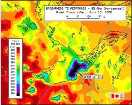
Space-based microwave sensors register the amount of radiation emitted by objects. The sensors react strongly to open water assigning very low "brightness temperatures" (a measure of the intensity of radiation thermally emitted by an object) to sections of the lake free of ice while ice covered surfaces register much higher brightness temperatures, said Walker. Researchers looking at the images, which are color coded to reflect variation in temperature, can readily distinguish between open water and ice cover. However, because of the poor resolution of passive microwave satellite sensors little research had been done with applying this type of remote sensing to lake ice prior to 1987, Walker said.
"The availability of finer resolution satellite sensors, covering more of the globe on a daily basis than previously, allowed us to monitor ice extent and duration on the larger lakes, providing a significant improvement in our current knowledge of the microclimate of the Great Slave Lake," she said.
Images created from National Snow and Ice Data Center (NSIDC) satellite data showing ice formation and melt enhance the feasibility of lake studies for scientists and climate modelers, Walker said. Using NSIDC's passive microwave data set simplifies image analyses for modelers since data points within the images are on a fixed grid, allowing easy comparison of discrete 12.5-square-kilometer areas for any date or time, said Walker.
Lake water evaporation is an important component in short-term climate system modeling, said Walker. Atmospheric water vapor affects the hydrologic cycle and influences climate. Thus, a clear sense of how and when ice forms and melts is essential to understanding short-term climate phenomena, Walker said.
(Note to researchers: The DMSP SSM/I Pathfinder Daily EASE-Grid Brightness Temperatures data set consists of three series produced on CD-ROM, one series each for the EASE-Grid Northern Hemisphere, Southern Hemisphere and Cylindrical (global) projections. Coverage is global and processing is ongoing.)
NASA's National Snow and Ice Data Center Distributed Active Archive Center (NSIDC DAAC) is a data and information resource for researchers studying snow and ice and their importance to the Earth system. NSIDC DAAC archives analogue and digital snow and ice data, creates and distributes data products, and maintains a large library collection in support of snow and ice research. For more information, visit the NSIDC DAAC website.
"We focused our research on Great Slave Lake because other sources of information on freeze-up and break-up were available for comparison with our results. Now that we have determined that we can readily discriminate between areas of open water and ice on the, Great Slave Lake we plan to use the satellite images to monitor ice on Great Bear Lake," Walker said.
Scientists at the Climate Research Branch created a series of images tailored for researchers who model the interactions between the surface and atmosphere. These images reveal the timing of Canadian lakes freeze and break-up. The launch of the Advanced Microwave Scanning Radiometer (AMSR), a satellite equipped with a higher resolution sensor, may allow retrieval of lake ice information from the myriad of smaller lakes.
References
Walker, A. E., and M. R. Davey. 1993. Observation of Great Slave Lake ice freeze-up and break-up processes using passive microwave satellite data. Proceedings of the 16th Canadian Symposium on Remote Sensing, p. 233-238.
For more information
NASA National Snow and Ice Data Center Distributed Active Archive Center (NSIDC DAAC)
| About the remote sensing data used | ||
|---|---|---|
| Sensor | Defense Meteorological Satellite Program (DMSP) Special Sensor Microwave Imager (SSM/I) Equal-Area Scalable Earth Grid (EASE-Grid) |
|
| Parameter | lake ice | |
| DAAC | NASA National Snow and Ice Data Center Distributed Active Archive Center (NSIDC DAAC) | |

