The United Nations (U.N.) Climate Change Conference being held November 30 to December 12, 2023, (known as COP28) marks the conclusion of the first United Nations Framework Convention on Climate Change (UNFCCC) Global Stocktake (GST). The stocktake is a five-year effort to create a global climate inventory, and, as noted on the U.N. Climate Change Portal, looks at everything related to where the world stands on climate action and support to identify gaps and chart a course forward.
A unique platform created through a NASA/ESA (European Space Agency) collaboration—the Multi-Mission Algorithm and Analysis Platform (MAAP)—will play a key role in assessing global biomass stocks and changes as part of this U.N. work. Recently published NASA-funded research supported by the Committee on Earth Observation Satellites (CEOS) and utilizing MAAP explores how biomass maps from multiple sources can be harmonized and used collectively.
Biomass and Biomass Maps

Biomass refers to the living part of vegetation systems, and it plays a crucial role in Earth’s climate. Destruction of vegetation releases carbon dioxide, a greenhouse gas, to the atmosphere. At the same time, vegetation pulls carbon dioxide out of the atmosphere and stores it as biomass. Biomass changes, especially in forests, can be both a key cause of climate change as well as a way to mitigate it.
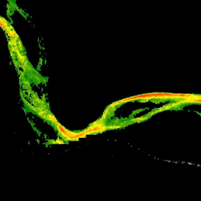
Using open data from missions and initiatives conducted by multiple space agencies is one way global biomass can be consistently and periodically assessed. Biomass-related airborne and satellite missions include NASA’s Global Ecosystem Dynamics Investigation (GEDI) and Ice, Cloud, and land Elevation Satellite-2 (ICESat-2); ESA’s Sentinel missions; the joint NASA/ESA AfriSAR airborne mission; and the upcoming ESA BIOMASS and NASA/Indian Space Research Organization Synthetic Aperture Radar (NISAR) missions. In addition, undertakings such as ESA’s Climate Change Initiative (CCI) combine a suite of satellite data and provide higher-level products, including global biomass maps.
While NASA, ESA, and other national space agencies, along with the NewSpace commercial sector, are producing a wide range of biomass maps, transparency in biomass map products, flexibility of definitions, and the assessment of their inherent uncertainties are required for these maps to be useful in national policy-related biomass reporting, which supports undertakings like the GST. Analyzing how biomass maps from multiple sources can be harmonized for global use is a research objective perfectly suited for MAAP.
“The faster the science of space-based biomass estimation advances, the greater the risk of products being disparate, and hence disregarded or incorrectly used in the policy domain, which is detrimental to any contribution to efforts towards climate change mitigation,” says Dr. Neha Hunka, assistant research professor in the Department of Geographical Sciences, University of Maryland, and principal author on the research. “MAAP is a platform that brings both transparency and collaboration between teams involved in forest biomass estimation, allowing them to work through datasets consistently and comparably, and to communicate a clearer message on forest biomass stocks.”
MAAP Overview
MAAP is an ongoing NASA and ESA effort and reflects the cooperation between the two agencies under the NASA and ESA Joint Program and Planning Group (JPPG) Joint Working Group (WG) on Ground Segment and Operations. MAAP was designed to support collaborative research, and brings together relevant data, algorithms, and computing capabilities in a common cloud environment to address the challenges of sharing and processing data from field, airborne, and satellite measurements. In keeping with NASA open data policies, all MAAP data, services, and software are available to research and applications communities, private industry, academia, and the general public.
MAAP in Action: Comparing Biomass Estimates from Satellite Data
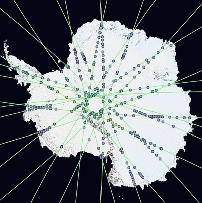
The CEOS Biomass Map Harmonization effort, which is funded by MAAP and NASA’s Terrestrial Ecology Program, used MAAP to comparatively assess two sets of aboveground biomass density (AGBD) estimates: one set derived from NASA GEDI data and another set provided by ESA’s CCI. The objective of the work was to ensure that the biomass estimates from these two sources can potentially be used to inform subsequent cycles of GSTs.
MAAP provided direct access to the biomass maps used as well as access to some of the underlying data that went into the production of these maps. The flexible algorithm development and rapid computation provided by the platform allowed the intercomparison of the underlying methods and assumptions used in production of the maps. In addition, the platform facilitated the production of national and sub-national estimates of forest biomass in a transparent, coherent, and consistent manner. As noted by the research team, MAAP’s open-science approach has fostered the first open-dialogue and open-data collaboration between various science teams involved in forest biomass estimation.
MAAP was used to intercompare two of the latest (as of April 2023) estimates of forest biomass, generate sub-national estimates for countries with varying forest definitions and ecoregions, and subset GEDI footprint-level relative vegetation height metrics for ecoregions that needed a closer investigation—all within the same platform with access to every necessary dataset. This unique functionality allowed assessments to be conducted within days of the public release of new biomass maps.

Backed by Amazon Web Service (AWS) cloud-computing services, MAAP enabled algorithms that would traditionally be run either in sequence or manually to run in parallel. The research team notes that the ability to conduct work in parallel in the cloud cuts global-scale analyses to 1/10,000th of the time it would have taken using a non-cloud-based system.
“MAAP is critical for this type of research as it allows full transparency into biomass map intercomparison and validation, which will be increasingly important in the years to come as we have more and more satellite-based approaches to biomass mapping and monitoring,” says Dr. Laura Duncanson, assistant professor in the Department of Geographical Sciences, University of Maryland. “MAAP enables collaboration across different research groups and agencies, which is demonstrated here between the NASA GEDI and ESA CCI teams working together to align their respective products to policy needs.”
Next Steps
Hunka notes that the next objectives in the MAAP biomass harmonization effort are to make global biomass maps directly useable for national reporting. This involves creating unambiguous and transparent guidance and source code for comparing biomass estimates to national forest inventories, the integration of biomass estimates and inventories, and the estimation of uncertainty when using biomass maps as either stand-alone datasets or as auxiliary information to national forest inventories. In addition, the research team plans to release source code for the presentation of estimates from biomass maps in a manner directly comparable to, and usable in, the guidelines of the Intergovernmental Panel on Climate Change (IPCC).
MAAP also continues its evolution, and the MAAP team will maintain the fruitful NASA/ESA collaboration. The platform is being integrated with the developing suite of NASA visualization and analysis tools that are part of the agency’s Visualization, Exploration, and Data Analysis (VEDA) dashboard. MAAP also is playing a key role in upcoming missions by demonstrating capabilities for developing higher level products incorporating synthetic aperture radar (SAR) data in biomass and forest structure products for the upcoming NISAR launch.