The oceans and the atmosphere are eternally intertwined in a game of give-and-take. Each reacts to changes in the other. These reactions and counter-reactions can snowball until the system builds to a point where everyday people notice the effects.
In the fall of 1996, easterly winds raced across the Pacific Ocean, keeping warm water bottled up near Indonesia. Waters off the coast of Peru remained cool. In December, however, a quick burst of wind shot eastward toward Peru, against the normal flow of the trade winds. In retrospect, this wind reversal was the first sign of the devastatingly strong 1997/1998 El Niño that would later be blamed for destroying homes, taking lives and consuming vast acres of normally damp forest.

The December westerly wind burst set the stage for a second wind spurt in March 1997. This westerly wind cleared a path eastward for a wave of warm water — a "Kelvin Wave." When this warm water pulse reached South America, it disrupted the normal easterly trade winds, diminishing them enough to allow even more warm water to migrate eastward. By May of 1997, the trade winds had ceased, and a pool of warm water continued to build in the eastern equatorial Pacific. El Niño was underway.
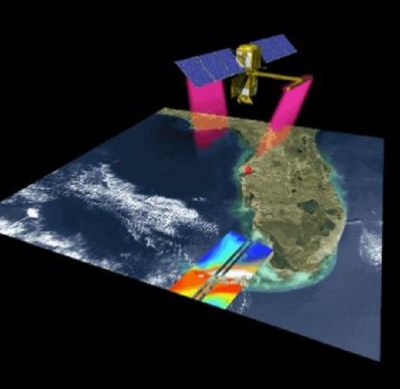
Scientists monitoring the ocean were announcing El Niño in May. TOPEX/Poseidon, the Jet Propulsion Lab's satellite launched in 1992 to measure sea level rise, had seen the gradual build-up of warm water in the eastern equatorial Pacific.
According to JPL research oceanographer Victor Zlotnicki, a change in sea level is directly correlated to a change in thermocline depth. "Near the equator, when sea level rises one inch, the thermocline goes down 200 inches," he said. The thermocline is a sharp separation of warm upper water from cold deeper water in the ocean. The lower the thermocline, the more heat stored in the water. So, by measuring the amount of sea level rise in the Eastern Pacific, TOPEX/Poseidon allows scientists to determine the amount of heat stored in the water.
In 1997, using TOPEX/Poseidon, scientists saw as much as a 16 inch rise in sea level in the eastern equatorial Pacific and nearly a 350 foot dip in the thermocline, both unmistakable signs of El Niño.

Plans for a follow-up mission are already set, said TOPEX/Poseidon Chief Scientist, Lee Fu. "We want to understand many cycles of El Niño, so we want to extend the data stream by launching a sequence of missions like TOPEX/Poseidon," he said.
The next mission, called Jason-1, is, like TOPEX/Poseidon, a joint effort of the United States and France. It is planned for launch in 2000 and will also collect sea level data, but with perhaps greater accuracy. "The goal is to reach one centimeter accuracy," Fu said.
The need for an ocean monitoring system became apparent when the 1982/1983 El Niño, the strongest of the century, arrived undetected by the science community. In response, under the auspices of the Tropical Ocean Global Atmosphere program, scientists developed a collection of buoys to measure large-scale changes in the ocean and to help detect El Niño events as they develop. These 70 buoys, called the Tropical Atmosphere Ocean Array, sit stationary in the tropical Pacific giving scientists a daily record of ocean changes.
Because each buoy in the array only measures the water in which it sits, the system gives a dotted view of the ocean, unlike the full ocean view TOPEX/Poseidon provides. "The buoys occupy a very narrow strip along the equator in the Pacific," Fu said. "El Niño is a very large-scale phenomenon. Just knowing the information along the equator is not enough. The Topex/Poseidon data give a global view of the Pacific." Still, the buoys are a major piece in the El Niño monitoring system. Because of TOPEX/Poseidon's global monitoring capabilities, the 1997/1998 El Niño was the earliest detected El Niño event ever. "This is the first time we saw it right from its beginning," said William Patzert, research oceanographer at JPL.
Ants Leetma at the National Oceanic and Atmospheric Administration used TOPEX/Poseidon data in a prediction model that enabled him to detect El Niño in March of 1997, months before the rest of the scientific community.
For the first time, preparations were made in the summer before an El Niño winter. "This forecast was distributed early, and it was taken seriously," Patzert said. "There was so much information available that preparations were made all across the country at a local, state and national level. The loss of life and property in this particular event definitely could have been much worse than it was." Although Leetma's model was the first to detect El Niño in March, a true prediction of the event would have come in the fall, before the appearance of the first Kelvin Wave. But scientists are not yet able to predict El Niño before its first signs show in the ocean, according to Patzert. "There will be no prediction unless there is a major revolution in our thinking and major advances in the way we model these events," he said. "The present generation of models is primitive. I think we are ten years away (from a prediction of El Niño)."
If these predictions come to fruition, we will be talking about El Niño for more than a year before we feel its atmospheric effects. In the winter of 1997/1998, the talk began six months before the weather.
Although the current detection abilities provide a six-month warning for the continental United States, science does not benefit the Southern Hemisphere as much. In these areas, El Niño's effects come in June, directly on the heels of a detection in May. Therefore, South America and Indonesia have the most to gain from long-term El Niño predictions.
The 1997/1998 El Niño has been called the most destructive in recent history in tropical latitudes. The Brazilian government has spent hundreds of millions of dollars fighting fires that have destroyed hundreds of thousands of acres of forest and savanna. In Indonesia, farmers continued their normal agricultural burning practices expecting the seasonal rains to extinguish the fires. The rains never came, and the forests burned out of control. Ecuador and Peru saw months of almost non-stop torrential rain starting in June 1997 that destroyed more than 30 percent of the countries' infrastructure, according to Patzert. The 1997/1998 El Niño was so devastating in these regions because the May warning did not allow enough preparation time.
The accumulation of TOPEX/Poseidon data from one El Niño to the next gives scientists the best conditions in which to develop forecast models that would give the Southern Hemisphere more warning. "The more events we collect data on, the better the models will become," Patzert said. "The observations will lead the models into the first generation of meaningful prediction."
For more information
NASA Physical Oceanography Distributed Active Archive Center (PO.DAAC)
| About the remote sensing data used | ||
|---|---|---|
| Sensor | TOPEX Poseidon | |
| Parameter | ocean monitoring system | |
| DAAC | NASA Physical Oceanography Distributed Active Archive Center (PO.DAAC) | |