Former President Richard Nixon created the United States Environmental Protection Agency (EPA) on December 2, 1970, to protect human health and the environment. That same year, the U.S. Congress passed the Clean Air Act (CAA), which empowered the EPA to regulate six criteria air pollutants: particulate matter (PM, also known as particle pollution), ozone (O3), sulfur dioxide (SO2), nitrogen dioxide (NO2), carbon monoxide (CO), and lead (Pb). As a result of the CAA's tighter regulations on the emissions of these pollutants from cars and industrial activity, the air quality of the United States improved significantly. The same can be said for the air quality in Europe following the passage of similar regulations in Britain and other European nations.
"The data show us that the U.S. and Europe have some of the highest emissions in the world," said former President Barack Obama. "But it also shows us that, in the last 25 years, NO2 levels have dropped by up to 50% in both regions, thanks in large part to new rules that protect our air. [Satellite] Imagery . . . can help us see what actions are working, and where we need to focus additional international efforts."
As this quote suggests, observations from sensors such as the Ozone Monitoring Instrument (OMI) aboard NASA's Aura satellite, the agency's third flagship Earth Observing System satellite mission behind Terra and Aqua, have been critical for measuring criteria pollutants such as O3, NO2, SO2, and ozone-destroying chlorofluorocarbons (CFCs). Further, these observations have been instrumental in allowing both policymakers and scientists around the globe to determine whether regulations like the CAA and the Montreal Protocol on Substances That Deplete the Ozone Layer are having their desired effect.
Aura launched in 2004, and since then instruments aboard other satellites, such as the Ozone Mapping and Profiler Suite (OMPS) aboard the NASA/NOAA Joint Polar Satellite System (JPSS) series of satellites, the TROPOspheric Monitoring Instrument (TROPOMI) aboard the ESA (European Space Agency) Sentinel-5P spacecraft, and the Earth Polychromatic Imaging Camera (EPIC) aboard the Deep Space Climate Observatory (DSCOVR) spacecraft orbiting on Lagrange point L1 between Earth and Sun, have become the primary sources for daily global hyperspectral observations of pollutants, trace gases, and other aerosols. Now, NASA has taken the next step in air quality monitoring with the April 7, 2023, launch of the Tropospheric Emissions: Monitoring of POllution (TEMPO) mission.

TEMPO is an ultraviolet and visible spectrometer designed to observe the chemical components of the atmosphere over North America with more detail, precision, and timeliness than ever before. From its geostationary position 22,000 miles above Earth's equator, TEMPO is providing hourly measurements of O3, NO2, and other key elements of air pollution over its entire Field of Regard (or field of view), from the Atlantic to the Pacific, and from the Yucatan Peninsula to the Canadian oil sands.
"The instruments in low Earth orbit like OMI, TROPOMI, and OMPS can only observe a particular location once per day; but TEMPO, which is sitting in geostationary orbit over the equator, can measure most of North America on an hourly basis in normal operation," said Dr. Xiong Liu, senior physicist at the Smithsonian Astrophysical Observatory and deputy principal investigator for the TEMPO mission. "Also, in special observation mode you can sacrifice coverage of TEMPO's entire field of regard to focus on a particular location, such as a large wildfire, to take measurements every 10 minutes."

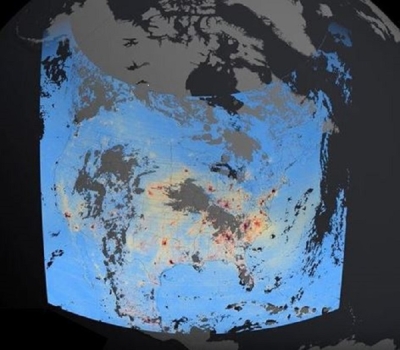
NASA offered a glimpse of TEMPO's capabilities when it released the first data maps from the instrument on August 24, 2023. These maps, which show concentrations of NO2 pollution over North America on August 2, present six hourly scans acquired between 11:15 am and 5:15 pm, EDT. Included among them are closeups of the I-95 corridor along the U.S. Atlantic Coast, central and eastern Texas to New Orleans, and the southwest U.S. from Los Angeles to Las Vegas.
As these maps suggest, TEMPO's enhanced spatial and temporal resolution—hourly measurements from east to west of its entire field of view and 2-kilometer (km) per pixel resolution north to south and 4.75-km per pixel resolution east to west at the center of the field of regard—will allow scientists, air quality agencies, public health officials, and other stakeholders to pinpoint areas of pollution and track pollution movement.
"On average, TEMPO has twice the spatial resolution of TROPOMI, our most advanced instrument in low Earth orbit, and with hourly observations compared to just one per day, it will allow us to understand a lot more about air pollution, including where [the pollution] comes from and where it goes," said Liu. "It will also give us more information about the rapidly varying emissions, chemistry, and transport of atmospheric pollution, such as the locations and movement of pollution during rush hours. Geostationary measurements are the primary way to get insights into the processes that effect air quality throughout the day."
Dr. Hazem Mahmoud, science lead at NASA's Atmospheric Science Data Center (ASDC), agrees. "The satellites in low Earth orbit have shown us that, since the passage of the Clean Air Act in 1970, there has been a reduction in atmospheric pollution," he said. "But we can do better, and I think TEMPO is going to take us to the next level because we'll no longer be monitoring pollutants daily, we’ll be doing it hourly. This will let us see how the sources and concentrations of pollution change throughout the course of the day."
The TEMPO instrument was built by Ball Aerospace and flies aboard the Intelsat 40e satellite built by Maxar Technologies. Since its launch, teams from the Smithsonian Astrophysical Observatory (SAO), NASA's Langley Research Center, Intelsat, Maxar, and Ball have been checking and calibrating TEMPO’s systems and components. The instrument began full operations in late 2023 and, following the successful completion of calibration and validation exercises, the mission will begin releasing data products starting with Level 1B geolocated, calibrated solar radiances.
"The Level 1B radiances will be used to produce five baseline Level 2 products: total ozone, ozone profile, cloud fraction and pressure, NO2, and formaldehyde," said Liu. "The ozone profile product, which will provide measurements of ozone near the surface in the 0 to 2-km range, is based on an ozone profile algorithm developed for the OMI instrument, which only has O3 bands in the ultraviolet (UV) [wavelength spectrum]. TEMPO has additional O3 bands in the visible [wavelength spectrum], which provides additional retrieval sensitivity to measure ozone in the lower troposphere."
According to Liu, the Level 1B product will be available in February 2024. The release of Level 2 TEMPO data products is planned for April 2024.
In addition, Liu and his colleagues plan to produce additional data products in the coming years after the baseline mission is complete. These include products pertaining to aerosols, sulfur dioxide, water vapor, glyoxal, bromine monoxide, UVB, ocean color, and a suite of synergistic TEMPO/GOES-R products.
To help policymakers, researchers, and others become better acquainted with TEMPO's forthcoming data products and how TEMPO data might advance their work, the TEMPO Early Adopter program generated a dataset of TEMPO proxy data that interested users could practice with in their current analysis tools and workflows to learn how they could potentially use the upcoming TEMPO data. The TEMPO Early Adopter team has actively engaged with a range of end-users within the air quality and public health communities to maximize use of TEMPO data for societal benefit once the data are available publicly.
"The TEMPO Early Adopters group has been using the proxy data products to simulate what the actual data from the instrument will look like, so users can work that into their current processes and analysis techniques," said Matt Tisdale, a data scientist at NASA's ASDC, which will be NASA's archive for TEMPO data. "In return, the user community has been providing the [TEMPO] science team with a lot of input about how they plan to use TEMPO data once it becomes operational."

Liu notes that the Early Adopters program will help further expand the use of TEMPO data.
"The objective of the TEMPO Early Adopter program is to accelerate and broaden the application of TEMPO data," said Liu. "There are approximately 550 Early Adopters and we plan to begin releasing data products within six months of the start of normal operations. That’s very early compared to similar missions, so by training people on how to work with TEMPO data, we’re accelerating its application."
The TEMPO proxy trace gas products are generated from chemical transport models including the realistic Goddard Earth Observing System Model Nature Run (GEOS-NR) and the GEOS Composition Forecasting (GEOS-CF). These products account for the sensitivity, physics, and uncertainties associated with the trace gas retrievals. Proxy aerosol data are derived from current remote sensing observations. The proxy data are provided to the Early Adopter community in netCDF4 format following the file structure of the planned operational data. (Note: Users can get a glimpse of the TEMPO NO2 proxy data via the NASA Short-term Prediction Research and Transition Center (SPoRT) Viewer on the NASA Earth Science Office website.)
According to Tisdale, multiple agencies are interested in adding TEMPO data to their methodologies to improve their air quality forecasts. Regulators stand to benefit from the data as well, as the data will help them identify potential point sources of pollution within their states or communities.
As a case in point, along with being publicly available through the ASDC website and NASA's Earthdata Search, TEMPO data will also be accessible via the U.S. EPA Remote Sensing Information Gateway (RSIG) data tool, which allows users to subset large datasets from satellites, models, and in-situ sensors; integrate their selected datasets into a unified visualization; and distribute the data they've selected.
"RSIG is a tool that EPA uses, so we’ll be feeding TEMPO data to it," Tisdale said. "It has some re-gridding and other capabilities that are specific to the EPA, and there are users who are familiar with that tool, so on the back end, we’ll just feed TEMPO data products into it so they can be used by the EPA and its stakeholders."
The addition of TEMPO data to RSIG will also supplement data the EPA receives from its AirNow system, which is composed of thousands of monitoring stations on the ground across the United States, Mexico, and Canada. This system distributes national, real-time air quality reports for monitoring and forecasting air quality; however, the system’s ground stations are not all-encompassing.
"NASA and the EPA are working very hard to add TEMPO data to RSIG because, although the EPA has ground stations distributed around the United States, there aren't [many] data for the areas between them," said Hazem. "These two datasets will inform each other, and the TEMPO data are going to fill in the gaps for air quality researchers throughout North America."

Of course, the data TEMPO provides will be of interest to people far beyond the United States or even North America. Along with South Korea's Geostationary Environment Monitoring Spectrometer (GEMS), and the forthcoming ESA Copernicus Sentinel-4 instrument, TEMPO will be part of a global geostationary air quality (Geo-AQ) satellite constellation.
The combination of data from Geo-AQ and the global, but less frequent observations, from the existing instruments in low Earth orbit will allow researchers to track pollution transport between cities, states, countries, and even continents, significantly improving air quality forecasting in the most densely populated areas.
"In addition to these instruments in low Earth orbit, we already have GEMS over Asia, which launched in 2020, and we’re going to have Sentinel 4 in early 2025," said Liu. "These measurements can be used to validate TEMPO and the other geostationary satellites [in the Geo-AQ constellation]. All of these measurements can be used together to provide air quality coverage over the entire globe."
NASA's ASDC is located within the Science Directorate at NASA's Langley Research Center in Hampton, Virginia. ASDC manages, archives, and distributes NASA Earth science data related to radiation budget, clouds, aerosols, and tropospheric composition in NASA's Earth Observing System Data and Information System (EOSDIS) collection, and provides tools and applications for working with these data, which are important for understanding the causes and processes of global climate change and the consequences of human activities on Earth's atmosphere and climate.
Learn more
For more information about TEMPO, see the mission's website.