Lars Bromley is the principal analyst and a research advisor at the United Nations Institute for Training and Research - Operational Satellite Applications Programme
Research interests: Bromley helps to improve the integration of satellite imagery and geospatial data in supporting global UN operations and activities in the areas of disaster response, humanitarian support, human security, and human rights. His work also involves using Moderate Resolution Imaging Spectroradiometer (MODIS) thermal anomaly data products to monitor violent conflicts and for human rights applications. “Imagery from MODIS and Landsat plays an almost daily role in UNOSAT activities,” says Bromley.
Current Research/Work: Bromley monitors conflict dynamics and humanitarian operations in Syria, South Sudan, and elsewhere to support UN and non-governmental organization (NGO) operations. He recently completed an analysis of commercial high-resolution imagery in the eastern Democratic Republic of the Congo to document possible 2002-2003 settlement destruction to support the Office of the Prosecutor at the International Criminal Court. Bromley also is developing a Web-based system for analyzing the MODIS record of thermal anomalies to enable crowdsourced conflict monitoring and is advising a European Union-funded computing project that is developing tools for crowdsourced analysis of media from disasters, refugee settlements, and other issues of interest to the UN.
Data Products and Tools Used:
- MODIS Active Fire data, distributed by NASA's Fire Information for Resource Management System (FIRMS)
- MODIS Near Real-Time (NRT) imagery (250 m resolution, twice daily) that can be accessed at /lance/rapid-response
- Landsat 5, 7, and 8 imagery acquired from http://earthexplorer.usgs.gov
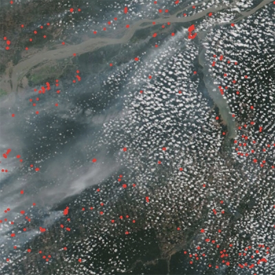
Research Findings: Bromley’s research linked MODIS-detected fires and thermal anomalies to reports of violence in the Darfur region of Sudan in 2003-2004, which formed the basis for the use of MODIS and other thermal anomaly detection systems for monitoring violent conflict. This method has been used to understand conflict dynamics in remote areas. Bromley presented these findings as evidence at the International Criminal Court in 2014 in relation to the 2007-2008 post-election violence in Kenya.
Read About the Research:
Bromley, L. (2010). Relating violence to MODIS fire detections in Darfur, Sudan. International Journal of Remote Sensing, 31(9). doi:10.1080/01431160902953909
Bromley, L. (2009). Eye in the sky: Monitoring human rights abuses using geospatial technology. Georgetown Journal of International Affairs, 10.1. Available online (link).
For more information
- Fire Information for Resource Management System (FIRMS)
- Near Real-Time (NRT) data
- Moderate Resolution Imaging Spectroradiometer (MODIS)