Dr. Rachel Albrecht, Professor, Department of Atmospheric Sciences, University of São Paulo, Brazil
Research interests: Cloud electrification, lightning, nowcasting of severe weather, cloud-aerosol-precipitation interactions (CAPI), and local circulation effects in deep convection.
Research highlights: If you live an 80-year life, your odds of being struck by lightning are 1 in 13,500, according to the National Weather Service, with a 1 in 1,083,000 chance of being struck in a given year. But lightning seems to play favorites, both for people and locations.
Roy Sullivan, for example, had what could be described as an attractive personality. Sullivan (1912-1983), a park ranger in Shenandoah National Park in Virginia, was reportedly struck by lightning seven times between 1942 and 1977. Aside from his hair catching on fire (several times) and burns from the strikes, he was otherwise unharmed. Or take the Empire State Building in New York City. This architectural landmark is hit an average of 23 times a year, according to the NWS.
And then there is Lake Maracaibo in Venezuela.

Recent research by Dr. Rachel Albrecht and her colleagues shows that Lake Maracaibo is Earth’s lightning hotspot. Using 16 years of lightning flash data collected by the Lightning Imaging Sensor (LIS) aboard the joint NASA/Japan Aerospace Exploration Agency Tropical Rainfall Measuring Mission (TRMM) - operational 1998 to 2015 - the research team determined that the lake has a Flash Rate Density (FRD) of more than 233 lightning flashes per square kilometer per year, surpassing the previous lightning hotspot of Kabare in the Democratic Republic of the Congo (which has a FRD of 205 flashes/km2/year). Albrecht’s research shows that lightning hotspots are created by local air circulations and the interactions of these circulations with surrounding topography. She also notes that the top 30 lightning hotspots identified by her research are related to complex terrain.
So why is Lake Maracaibo a natural lightning rod? Albrecht identifies several factors that work together to make the lake conducive to storms with an unusually high amount of lightning. For one, the lake is quite large (13,210 km2), with warm waters surrounded by mountains. The mountains channel mountain-valley and land-lake breezes over the lake at night where these air masses gain moisture from the lake as they are lifted. The result of this moist, unstable, uplifted air is localized nocturnal thunderstorms that persist over the lake.
Of course, you can’t have a thunderstorm without lightning. As these storms rise into much colder air high above the ground, the cloud droplets freeze and ice crystals, graupel, and hail form. When these ice crystals, graupel, and hail pellets collide within the cloud, the cloud's electrical charge becomes separated. After millions of collisions, so much charge is built up that a lightning discharge occurs, temporarily returning the cloud to a neutral charge. This process rapidly repeats as frozen droplets continue to collide.
Of the 500 global lightning hotspots ranked by Albrecht and her colleagues, 283 occur in Africa, which is the continental landmass with the highest number of hotspots (hotspots in other continental landmasses: Asia, 87; South America, 67; North America, 53; Oceania, 10). As a professor at the University of São Paulo, Albrecht notes that the top Brazilian lightning hotspot is found in the Amazon on the eastern shore of the Rio Negro River a few hundred kilometers from Manaus. Along with investigating the origins of this hotspot and the influence of river breezes on thunderstorm development, she also is investigating the impact of human-caused pollution on these thunderstorms.
For her atmospheric work in the Amazon, Albrecht integrates remotely-sensed satellite data with field data collected using two unique research tools - the Amazonian Tall Tower Observatory (ATTO) and the High Altitude and Long range research aircraft (HALO).
Located 150 km northeast of Manaus, Brazil, the ATTO is a joint German/Brazilian project soaring 325 meters (more than 1,000 feet) above the forest canopy and studded with instruments for measuring various greenhouse gases, analyzing aerosols, and collecting weather data. Research conducted at the tower is designed to collect data on the influence of the Amazonian rainforest on climate; understand sources and sinks of greenhouse gases such as carbon dioxide (CO2), methane (CH4), and nitrous oxide (N2O); investigate the formation of aerosols and their role in cloud formation; and study long-range transport processes of air masses and the influence of the Amazonian forest on these air masses.

The HALO aircraft soars even higher above the forest canopy. With its cruising altitude of more than 15 km (almost 50,000 ft.), a payload of up to three tons, and a range of more than 8,000 km (almost 5,000 miles), this unique German research aircraft facilitates continental-scale atmospheric measurements at altitudes as high as the lower stratosphere.
Albrecht points out that the Amazon is one of the few continental areas where it is still possible to observe atmospheric conditions during the wet season that resemble those that existed in pre-industrial times, especially in regard to aerosol concentrations. “Aerosol” is the term used to describe minute solid particles or liquid droplets that are suspended in air. Common aerosols include dust, water vapor, and smoke.
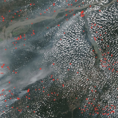
During the Amazon dry season, a majority of regional aerosols are from biomass burning. In addition, the city of Manaus in the heart of the Amazon is a source for aerosols from urban pollution throughout the year. These human-created aerosols serve as cloud condensation nuclei around which water vapor collects to form cloud droplets and, when large enough, rain and ice. The interaction of aerosols with cloud condensation nuclei and the impact of this on precipitation is referred to as Cloud-Aerosol-Precipitation Interactions (CAPI), which is a focus of Albrecht’s research.
Albrecht was part of a large multi-national campaign called the Aerosol, Cloud, Precipitation, and Radiation Interactions and Dynamics of Convective Cloud Systems (ACRIDICON), which used the HALO aircraft for atmospheric sampling across northern Brazil over Amazonia. ACRIDICON was conducted in conjunction with another campaign called Cloud processes of the main precipitation systems in Brazil: A contribution to cloud resolving modeling and the Global Precipitation Measurement (CHUVA) (chuva is the Portuguese word for rain). The CHUVA campaign collected data for the precise localization of intra-/inter-cloud and cloud-to-ground lightning in and around São Paulo and contributed data to the joint NASA/Japan Aerospace Exploration Agency Global Precipitation Measurement (GPM) mission (operational 2014-present). The goal of ACRIDICON-CHUVA was to quantify CAPI and thermodynamic, dynamic, and radiative effects of CAPI processes by combining field measurements with remotely-sensed satellite data.
One important finding from this campaign is that aerosols from urban pollution lead to a higher concentration of cloud condensation nuclei, which compete with water vapor to form cloud droplets. As a result, clouds in more polluted areas have a higher number of very small cloud droplets. The small size of these cloud droplets suppresses the process necessary for these small droplets to combine into large raindrops. This suppression, in turn, can result in no rain at all or it can give the cloud the extra time necessary to grow vertically to freezing temperatures and for the cloud droplets to freeze. As noted above, it is the collision of these frozen particles that leads to a separation of electrical charge in the cloud and the resulting lightning discharge.
Albrecht calls the Amazon a living laboratory for her studies of CAPI, cloud electrification, and lightning. As her research shows, certain areas have the right combination of ingredients to create hotspots for these powerful electrical displays—a fact the lightning-prone Roy Sullivan knew all too well.
Representative data products used:
- TRMM LIS 0.1 Degree Very High Resolution Gridded Lightning Climatology Data [doi:10.5067/LIS/LIS/DATA306]; available through the Global Hydrometeorology Resource Center Distributed Active Archive Center (GHRC DAAC)
- MODIS/Terra valueadded Aerosol Optical Depth [Short Name: MODAODHD; doi:10.5067/MODIS/MODAODHD.NRT.006]; available through the Level 1 and Atmosphere Archive and Distribution System DAAC (LAADS DAAC)
- Various data products from the National Oceanic and Atmospheric Administration’s Comprehensive Large Array-Data Stewardship System (CLASS)
- Data from the GoAmazon dataset; available through the U.S. Department of Energy’s Atmospheric Radiation Measurement (ARM) Climate Research Facility
- Data and research from the Amazonian Tall Tower Observatory (ATTO)
- HALO data from the ACRIDICON-CHUVA mission; available through the HALO database
Read about the research:
Braga, R.C., Rosenfeld, D., Weigel, R., Jurkat, T., Andreae, M.O., Wendisch, M., Pöschl, U., Voigt, C., Mahnke, C., Borrmann, S., Albrecht, R.I., Molleker, S., Vila, D.A., Machado, L.A.T. & Grulich, L. (2017). Aerosol concentrations determine the height of warm rain and ice initiation in convective clouds over the Amazon basin. Atmospheric Chemistry and Physics (in review). doi:10.5194/acp-2016-1155
Cecchini, M.A., Machado, L.A.T., Andreae, M.O., Martin, S.T., Albrecht, R.I., Artaxo, P., … Wendisch, M. (2017). Sensitivities of Amazonian clouds to aerosols and updraft speed. Atmospheric Chemistry and Physics, 17(16): 10037-10050. doi:10.5194/acp-2017-89
Albrecht, R.I., Goodman, S.J., Buechler, D.E., Blakeslee, R.J. & Christian, H.J. (2016). Where Are the Lightning Hotspots on Earth? Bulletin of the American Meteorological Society, 97(11): 2051–2068. doi:10.1175/bams-d-14-00193.1
Wendisch, M., Pöschl, U., Andreae, M.O., Machado, L.A.T., Albrecht, R., Schlager, H., … Afchine, A. (2016). ACRIDICON–CHUVA Campaign: Studying Tropical Deep Convective Clouds and Precipitation over Amazonia Using the New German Research Aircraft HALO. Bulletin of the American Meteorological Society, 97(10): 1885–1908. doi:10.1175/bams-d-14-00255.1
Machado, L.A.T., Silva Dias, M.A.F., Morales, C., Fisch, G., Vila, D., Albrecht, R., … Tokay, A. (2014). The Chuva Project: How Does Convection Vary across Brazil? Bulletin of the American Meteorological Society, 95(9): 1365–1380. doi:10.1175/bams-d-13-00084.1
Albrecht, R.I., Morales, C. A. & Silva Dias, M.A.F. (2011). Electrification of precipitating systems over the Amazon: Physical processes of thunderstorm development. Journal of Geophysical Research, 116(D8). doi:10.1029/2010jd014756
For more information
- Lightning Imaging Sensor (LIS)
- Tropical Rainfall Measuring Mission (TRMM)
- Amazonian Tall Tower Observatory (ATTO)
- High Altitude and Long range research aircraft (HALO)
- Aerosol, Cloud, Precipitation, and Radiation Interactions and Dynamics of Convective Cloud Systems (ACRIDICON)
- Atmospheric Radiation Measurement (ARM)
- Global Precipitation Measurement (GPM)