Dr. Kristine M. Larson, Professor of Aerospace Engineering Sciences, University of Colorado, Boulder, CO
Research interests: Plate tectonics and geodesy, with work developing new ways of using the Global Positioning System (GPS) to study Earth and the water cycle.
Research highlights: For many, GPS is a box that guides them around town or across the country. Thinking outside the GPS box, however, opens up this technology to innovative and extremely useful applications. The groundbreaking GPS research by Dr. Kristine M. Larson provides a good example of how a technology like GPS can be used for applications beyond its original intent.
Of course, like many serendipitous research discoveries, Larson’s work developing a technique called GPS Interferometric Reflectometry, or GPS-IR, began with her efforts to deal with unwanted GPS signal noise interfering with her research into plate tectonics and ground movement during earthquakes.
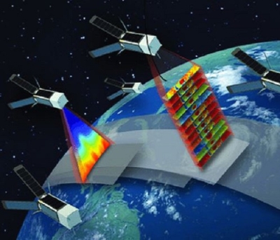
GPS is an excellent technology for measuring minute changes in elevation or distance, such as displacement caused by an earthquake or the continuous shifting of tectonic plates as they imperceptibly slide across Earth’s surface. GPS is the U.S. version of a Global Navigation Satellite System (GNSS). Other countries maintain similar systems, such as the European Galileo GNSS and the Russian Federation’s Global Navigation Satellite System (GLONASS). NASA’s home for GNSS data is the Crustal Dynamics Data Information System (CDDIS) at NASA’s Goddard Space Flight Center in Greenbelt, MD.

A GNSS system like GPS has three components: satellites in well-known orbits with synchronized clocks, ground controllers, and a ground segment providing data to users. As of February 16, 2018, the U.S. GPS constellation comprises 31 operational satellites orbiting more than 20,000 km above Earth, according to the federal GPS.gov website. Each satellite completes two orbits every day and sends out a unique one-way signal. Ground controllers keep track of satellite orbits and ensure that the clocks aboard each satellite are synchronized (the U.S. Air Force develops, maintains, and operates GPS space and ground control segments). Satellite signals are collected by a global network of receivers that detect, decode, and process these signals. Using signals from four satellites, a precise location in three-dimensions (within millimeters or less) along with precise time can be determined. By comparing measurements over time, minute elevation and distance changes at a station can be calculated. This is where Larson’s work started.
By training, Larson is a geodesist, which is the name given to scientists who measure and monitor the Earth to determine the exact coordinates of any point (the overall field of study is called geodesy). She initially used GPS data to measure deformation caused by plate tectonics, then began using GPS to study more dynamic signals, such as ground motions caused by earthquakes. While examining GPS seismic data, she noticed numerous errors caused by the GPS signals as they bounced on the ground before arriving at her scientific instruments. Erroneous signals outside the data being collected are called noise; for Larson, these erroneous GPS signals created an interference pattern that could be accounted for when analyzing her data. Still, this GPS noise was frustrating.

When Larson and her colleagues looked more closely at the GPS noise, though, they realized that the interference patterns they observed with ordinary GPS instruments correlated with the water content of the reflecting surface in the vicinity of the receiving antenna. By reverse-engineering the GPS reflections, Larson and her co-investigators were able to calculate a wide range of water cycle measurements, including soil moisture, vegetation water content, and snow depth and snow water equivalent (SWE). The technique they developed for using reflected GPS signals as a source for environmental data is called GPS Interferometric Reflectometry (GPS-IR).
Fortuitously, the development of GPS-IR coincided with the installation of the EarthScope Plate Boundary Observatory (PBO). EarthScope is a National Science Foundation (NSF) initiative to study the structure and evolution of the North American continent and the processes that cause earthquakes and volcanic eruptions. The PBO is a component of EarthScope that uses a large GPS network to precisely measure Earth deformation resulting from the constant motion of the Pacific and North American tectonic plates in the western U.S. Larson and her colleagues use PBO GPS data to measure shallow soil moisture variations, snow depth, vegetation water content, and water loading in a project called PBO H2O. PBO H2O soil moisture data were used to help validate sensor data from NASA’s Soil Moisture Active Passive (SMAP) mission, and PBO H2O snow data are archived at the National Snow and Ice Data Center Distributed Active Archive Center (NSIDC DAAC).
Building on their initial work, Larson and her colleagues used GPS-IR to measure water levels by seeing if a GPS receiver could be used as a tidal gauge. In an experiment conducted in Kachemak Bay, Alaska, the research team compared tidal coefficients acquired using GPS with tidal coefficients estimated from records acquired using a traditional tide gauge about 30 km away. Data from the two sources showed an agreement of 2.3 cm, indicating that GPS can be used to measure long-term sea-level changes. This water level methodology is now being used by geoscientists around the world.
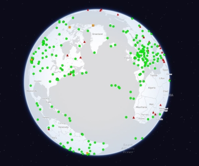
Larson notes that one great benefit of her GPS reflection studies is that they use existing GPS instrumentation and infrastructure. This global infrastructure currently includes a network of more than 12,000 continuously-operating GPS systems in every biome. In some cases, Larson has been able to use GPS data that have been archived for more than a decade and turn these data into new environmental products.

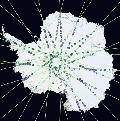
GPS-IR is now being used on every continent on Earth, including Antarctica, where it is being used to measure both snow accumulation and tides. In recognition of the significance of this work, the GPS Reflections Group led by Larson shared the 2014 Prince Sultan bin Abdulaziz International Prize for Water (PSIPW), Creativity Prize. The Creativity Prize is one of five biennial awards that are part of the PSIPW, and recognized the GPS Reflections Group for their “development of a new, unexpected, and cost-effective technique . . . to measure soil moisture, snow depth, and vegetation water content.”
Along with being a means of navigating from point to point, the innovative GPS and GNSS work and research by Larson and her colleagues broadens the use of this technology in ways far beyond those originally envisioned. What was once “noise” to Larson has now become a harmonious new way of assessing Earth’s water resources.
Representative data products used:
- Various GNSS data and orbit products; these data and products are available through CDDIS
- Daily Snow Depth and SWE from GPS Signal-to-Noise Ratios, Version 1. doi:10.5067/Z02Y1HGNFXCH; available through NSIDC DAAC
- Data from the North American Land Data Assimilation System (NLDAS) Forcing Dataset; these data are available through the Goddard Earth Sciences Data and Information Services Center (GES DISC)
- GPS data archived at UNAVCO, a non-profit university-governed consortium that facilitates geoscience research and education using geodesy
- Data from the PBO H2O project; available through the PBO H2O Data Portal
Read about the research:
Larson, K.M. (2016). GPS Interferometric Reflectometry: Applications to Surface Soil Moisture, Snow Depth, and Vegetation Water Content in the Western United States. Wiley Interdisciplinary Reviews: Water (WIREs Water), 3(6): 775-787. doi:10.1002/wat2.1167
Larson, K.M., Wahr, J. & Kuipers Munneke, P. (2015). Constraints on Snow Accumulation and Firn Density in Greenland Using GPS Receivers. Journal of Glaciology, 61(225). doi:10.3189/2015JoG14J130
Larson, K.M., Ray, R.D., Nievinski, F.G. & Freymueller, J.T. (2013). The Accidental Tide Gauge: A Case Study of GPS Reflections from Kachemak Bay, Alaska. IEEE Geoscience and Remote Sensing Letters, 10(5): 1200-1204. doi:10.1109/LGRS.2012.2236075
For more information
- Global Navigation Satellite System (GNSS)
- EarthScope Plate Boundary Observatory (PBO)
- PBO H2O Project
- Soil Moisture Active Passive (SMAP)