The annual wet season brings heavy rainfall to the densely populated country of Bangladesh. It also brings a fatal illness. Cholera, a bacterial infection spread by contaminated water, strikes the region twice a year, hitting once in the dry season when river flow is low, and then again during the fall wet season, when heavy rains swell the rivers to overflowing, often flooding the low-lying Bengal Delta region. In other areas of the world, cholera outbreaks tend to appear at the worst possible time, often following disasters that devastate sanitation systems.

Modern medicine has managed to control or eradicate a number of diseases, such as smallpox and polio, which used to kill people around the world. So why does cholera remain untamable? “Cholera is a bacteria that has learned how to survive in the environment,” said Shafiqul Islam, a Tufts University researcher who is studying the disease. “What that means is that there is no way we’re going to get rid of it.” While many diseases are spread primarily by human transmission, the bacteria that cause cholera lurk in the environment, breaking out and sickening people only when a specific mix of conditions appears. Islam and his research team think that the best way to attack the disease may be to take a new look at the environmental conditions that contribute to its spread—and use that data to develop ways to avert outbreaks.
An environmental disease
Cholera is a bacterial disease that causes uncontrollable diarrhea. It hits its victims fast: if untreated, people with cholera can die in less than twenty-four hours, as the fluid drains from their bodies. William Greenough, professor of medicine and international health at Johns Hopkins University, is a cholera expert. He said, “The infection operates through a powerful toxin that causes the intestinal tract to secrete and not absorb body fluids.” Once ill, people with cholera quickly become dehydrated, and soon die of circulatory collapse. Cholera is also incredibly contagious. Since it usually occurs in places with poor sanitation, or in places where a disaster has occurred, once people become infected it spreads through the population at an explosive rate.
In the early 2000s, University of Maryland biologist Rita Colwell discovered that cholera bacteria was not just spread through people: it also lived in the guts of microscopic aquatic animals called copepods, which float around in ocean waters feeding on algae and other tiny plants. Cholera could survive in the open ocean for months to years, making the jump to infect humans only when conditions became right for the cholera bacteria to reach the drinking water supply.

But exactly what environmental conditions lead to cholera outbreaks? If researchers knew what caused the cholera bacteria to flourish and spread, they might be able to prevent many deaths. Antarpreet Jutla, a Tufts graduate student, is working on cholera research with Islam. He said, “Three to four million people are affected by cholera around the world every year. But we still cannot predict it.”
Prelude to an outbreak
The researchers decided to start their project in Bangladesh, because it is home to the longest time series of cholera data. Hospital records there follow the twice-annual outbreaks back to 1980, providing some of the most detailed data on cholera in the world.
But despite the wealth of data on outbreaks, nobody knows when exactly they will happen. Earlier studies had found potential connections between cholera outbreaks and a number of environmental factors, but most of those studies had focused on specific locations and short time periods. For example, researchers would sample water from only one village, or record water temperatures in just a few locations surrounding an outbreak. Ali Akanda, another PhD student working with Islam and Jutla, said, “They would not know what is happening in the next village or next country, where there might be similar environmental conditions.”
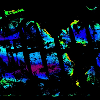
The researchers wanted to explore those environmental factors from a broader perspective. While the link between copepods and cholera was clear, they did not know what factors allowed copepods to multiply and spread the disease from ocean waters into drinking water. Copepods cannot be measured directly over a large area; the tiny animals are invisible to the human eye. But the brilliant green phytoplankton, which copepods rely on for food, gives them away. “Phytoplankton contain chlorophyll, which gives greenness to the ocean waters that we can measure from satellites,” Islam said.
Islam, Akanda, and Jutla combined the long-term disease data with environmental data including air and ocean temperature, salinity, and precipitation, and ten years of chlorophyll data from NASA's Sea-Viewing Wide Field-of-View Sensor (SeaWiFS), from NASA's Ocean Biology Distributed Active Archive Center (OB.DAAC). The SeaWiFS data indicated the amount of copepod-supporting phytoplankton in the water.
In the spring, when hot temperatures and arid weather dry up the Bengal delta region, cholera outbreaks were strongly linked to both chlorophyll levels and salinity in the river waters, two factors that help support the copepods that carry cholera. Akanda said, “In the dry season, the freshwater flow from rivers upstream is low. So there is a lot of salt water intrusion in coastal areas.” The movement of ocean waters upstream brings the copepods from the oceans to the rivers, while the extra salt creates a welcoming home for the algae and the copepods that feed on them. “What happens is a huge area—around 20 percent of the area around Bangladesh—becomes good for bacteria growth,” Akanda said.
In contrast, during the rainy fall season, the team discovered, cholera outbreaks were instead linked to flooding and rainfall, which spread dirty water and contaminated wells. Jutla said, “Our results suggest that we could predict two seasonal outbreaks in Bengal Delta, two to three months in advance, with a very high accuracy.”

Outsmarting an outbreak
In places like Bangladesh, cholera is not going away. Akanda said, “If you go to that part of the world, the rivers are ways of life.” People bathe, wash, fish, and cook in river water, and in times of need they even drink it. But the very persistence of the disease has actually helped efforts to fight it. While deadly, cholera is easy and inexpensive to treat. There is a vaccine, good for short-term protection, but most people need only to drink a specific mixture of sugar, salt, and water known as oral rehydration solution, to survive the infection. In Bangladesh, the mortality rate from cholera is now less than one percent. Greenough said, “Knowledge in the population ahead of time is the best defense against death due to cholera.”
But in other parts of the world, cholera appears unexpectedly and can catch vulnerable populations unprepared. In Haiti, for example, cholera appeared months after a massive earthquake reduced cities to rubble. Before that outbreak, Haiti had not seen cholera for a hundred years. The disease spread to more than 400,000 people in Haiti in the few months after it started and by March 2011, it had killed 4,600. Knowing a few months ahead of time that cholera would strike could have given aid workers enough time to intervene. Greenough said, “In areas where you identify the risk, you could get in well ahead of time and immunize the population at a very low cost and provide accurate information about making and using oral rehydration therapy solutions.”
Islam and his team are now expanding their research to other regions that see occasional cholera outbreaks, and other underdeveloped areas where a cholera outbreak can cause massive illness and death. Islam said, “We want to create actionable knowledge. We want to be able to predict what will be the next Haiti.”
References
Akanda, A. S., A. S. Jutla, M. Alam, G. C. de Magny, A. K. Siddique, R. B. Sack, A. Huq, R. R. Colwell, and S. Islam. 2011. Hydroclimatic influences on seasonal and spatial cholera transmission cycles: implications for public health intervention in the Bengal Delta. Water Resources Research, doi:10.1029/2010WR009914.
Jutla, A. S., A. S. Akanda, and S. Islam. 2010. Tracking cholera in coastal regions using satellite observations. Journal of the American Water Resources Association 46 (4):651-662, doi:10.1111/j.1752-1688.2010.00448.x.
Kuehn, B. M. 2010. Use of Earth-observing satellite data helps us predict, prevent disease outbreaks. Journal of the American Medical Association 303 (5):403-405, doi:10.1001/jama.2010.32.
For more information
NASA Ocean Biology Distributed Active Archive Center (OB.DAAC)
Sea-Viewing Wide Field-of-View Sensor (SeaWiFS)
| About the remote sensing data used | |
| Satellite | GeoEye OrbView-2 |
| Sensor | Sea-Viewing Wide Field-of-View Sensor (SeaWiFS) |
| Data sets | SeaWiFS Monthly Chlorophyll Data |
| Resolution | 9 kilometer |
| Parameter | Chlorophyll concentration |
| DAAC | NASA Ocean Biology Distributed Active Archive Center (OB.DAAC) |