Since the launch of the joint NASA/Japan Aerospace Exploration Agency Tropical Rainfall Measuring Mission (TRMM) in 1997, NASA has continually collected global precipitation data using orbiting satellites. The most recent precipitation mission, the joint NASA/JAXA Global Precipitation Measurement (GPM) Core Observatory, launched in 2014. GPM expands NASA precipitation data to the mid-latitudes, and includes measurements of both liquid and frozen precipitation. Ensuring that these data meet GPM mission requirements as well as user needs in terms of content, quality, and availability is a critical task that is managed by GPM Project Scientist Dr. Gail Skofronick-Jackson. As Dr. Skofronick-Jackson observes, NASA precipitation data have far ranging uses for both science and society.
Your Ph.D. is in electrical engineering, yet a majority of your GPM work involves meteorology and physical processes. Do you see yourself as an electrical engineer, a meteorologist, or a combination of these two fields?
My background is all electrical engineering. But I don’t build instruments. I’m a pure scientist who looks at science from a modeling point of view, an engineering point of view, an instrument point of view. I think this is my greatest strength—knowing how the instruments take these data and how these measurements relate back to the physical properties that are being measured. I understand how to take the physical measurements and model these into what the satellite sees. This is a really important aspect, because if you don’t understand this relationship, you can’t have good algorithms.
What is the significance of TRMM and GPM data?
We can use these data for scientific research and societal applications. Scientifically, this is really important information. We can put it into weather forecast models and climate change models because both of these [models] have a fairly simplistic representation of the snow and the ice within the cloud.
On the societal benefit side, the more data that you have in terms of where, when, and how precipitation—rain and snow—is falling, the better idea you have of where floods might occur, where landslides are more probable, and where there are droughts. With the data we get over the oceans you can see exactly where the hurricane eyes are located and where they are likely to make landfall.
How are these precipitation data collected?
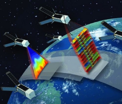
TRMM and GPM data are collected using two different instruments that help us understand the storms, precipitation, and storm structure. One instrument is a radiometer. With the radiometer, the measurements are integrated through the precipitating cloud, so you can see total columnar intensities of rain and ice that provides horizontal structure of the precipitating event.
The other instrument is a radar. The radar allows us to see layer-by-layer within the storm. Every 250 meters vertically you can see the characteristics of the precipitating particles; essentially their size distributions. Through the radar data you can tell where the melting layer is because these frozen drops, which tend to be bigger than the liquid drops, get coated with liquid and appear like large raindrops leading to this big bulge in the data identifying the melting layer. You can tell different parts of the storm with the radar and you can see the storm three-dimensionally. Now, I’ve made this all seem so easy! In reality, the radar and radiometer measure reflectivities and brightness temperatures, respectively, that need sophisticated retrieval algorithms to convert them into precipitation information.
How does NASA’s Precipitation Processing System aid in producing precipitation information?
Our Precipitation Processing System (PPS) takes the data and converts them into the rain rates. Since the measurements from the radar are radar reflectivities and the measurements from the radiometer are brightness temperatures, you need to have an algorithm that converts these measurements into rain rates. There are science teams and algorithm teams leading investigations to develop the algorithms. PPS puts these algorithms into production so you can get rain rates.
The other really important thing through PPS is that we have near real-time (NRT) products. This started with TRMM. It was not part of the TRMM requirements, but it is part of the GPM requirements. Our products are out anywhere from an hour to four hours after we get the data. These NRT products are very helpful for monitoring on-going storms and for short-term forecasting.
Tell me about your data users.
We have two user communities. We have the sophisticated science users who have been working with satellite data forever and they know exactly how and where to go to get their data and analyze these data. These science users may want 25 flavors of the precipitation data. But there’s a whole other community out there that is the applications community. They are used to their own applications area; they know they want precipitation data, but they don’t necessarily know all the very fine attributes that the hard-core science users are requesting. The applications users just want to know what the rain rate is right now and which rain rate is the best to use for their specific application. It’s interesting to work with two different user communities. The users have been very receptive to our intensive efforts to communicate how to access the data.
What can data users expect in terms of new GPM data enhancements or products?
The snow algorithm has fairly high error bars right now since snow retrievals from space are in their infancy and [snow] rates are very difficult to measure on the ground so you can actually validate the GPM data. These snow particles are all different shapes and sizes and they flutter as they fall. This makes it very difficult to accurately determine snow rate. We’re trying to improve this algorithm to eliminate some of these error bars.
In terms of new products, we’re looking more at applications-related products and application activities. We’re also trying to get data to these types of users so they understand how to use it. We have workshops for applications users about once a year where we say here are the data, here’s how you can go and get them, here are some plotting routines, and here are some completed plots. Our overall goal is to make sure that the science and application communities know how to use the data and get to the data.
Along with your work on GPM, you also are Chief of the Mesoscale Atmospheric Processes Laboratory. Tell me about this lab and the products available through this lab.
This lab is an interesting mix of people. We have the hard-core GPM scientists who are developing algorithms for GPM and TRMM and who are using the data scientifically. We have a group of modelers who develop cloud models that are used for GPM and to predict the weather for field campaigns and other modeling projects. One of our lab groups developed the Cloud-Aerosol Transport System (CATS) instrument on the International Space Station, which is looking at cloud particles. We also have a group looking at aerosols and the whole spectra of how clouds form. We have people building instruments for air and space, we have people doing science with satellite data, and we also have some ground validation people. There also are four labs within our lab where equipment is tested and built.
As an electrical engineer, do you ever want to get more hands on in the lab?
Oh yes, I love this! I’d like to think that the engineers in this lab appreciate that I understand some of these things.
Do you ever miss not being as hands-on as you were as an electrical engineer?
I really enjoyed the days when GPM was being built here at Goddard. I was much more immersed in the engineering and the science. I understood what was going on with the engineering. I was the GPM Deputy Project Scientist at the time, and the current project scientist was much more of a pure scientist who did not have engineering training. I could sit on the fence and say, oh, engineers are having a problem and I think this is how this problem might affect the science. So I was a translator between the engineers and the science team.
What are the next steps in using satellites to measure global precipitation? Where do we go from GPM?
The GPM team submitted a recommendation to the 2017 Earth Science Decadal Survey for a new precipitation mission that is not a GPM follow-on, but a step beyond GPM in that we would look at clouds and precipitation. In TRMM and GPM, the instruments were only sensitive to precipitation-sized particles; we couldn’t see stuff that’s not precipitating. So we put in a request for a mission to look at cloud particles and the precipitating particles. You want to know what water is being retained in the atmosphere and what falls out. What’s retained is what affects the cloud patterns which, in turn, affects the energy budget. Depending on the type of cloud, sunlight gets trapped or it gets reflected. This tells us more about both the hydrologic cycle and the energy budget cycle for global warming and the role that clouds play with that.
The next step beyond GPM also would be to sample at even higher latitudes. TRMM covered the tropics, GPM covers the mid-latitudes. The next step is to measure from pole-to-pole the sources of precipitation contributing to glaciers and sea ice.
What are some of the highlights of your role as GPM project scientist?
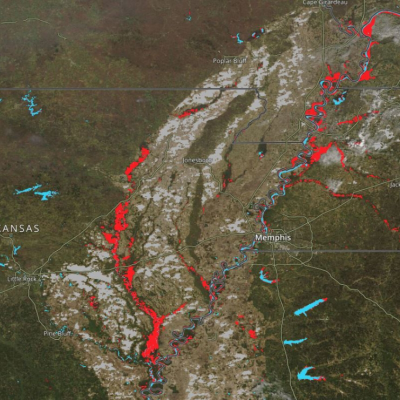
My professional background is falling snow, so I’m really excited that GPM can measure falling snow. In fact, just two-and-a-half weeks after launch we got one of the most visually compelling snow estimates we’ve ever seen during a snowstorm in the Washington, D.C., area. It’s just really rewarding to see the snow!
Also, there’s a large GPM science team out there. We have 60 principal investigators who are using TRMM and GPM data to further precipitation science and benefit society. Every time one of these scientists makes a new discovery or publishes a paper using these data it’s really rewarding to know that I had a small part in making this happen.
Sharing GPM with the science community and the public through outreach events and through Hyperwall presentations is also a highlight of my work. People understand the importance of precipitation; it’s essential for life on Earth.
You attended the GPM launch. Tell me about that experience.
My gosh, it was great! It was the first NASA launch I had ever seen and it was in Japan, a nighttime launch. My heart was pounding. It was beautiful; it was absolutely beautiful.