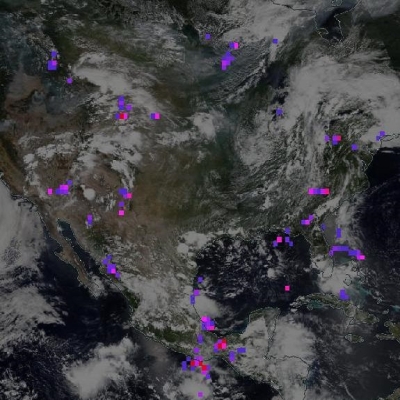
Knowing where fires are occurring when they are occurring—especially in remote and hard to reach areas—is one of the many benefits provided by NASA’s fleet of Earth observing satellites. Through the Earth Observing System Data and Information System (EOSDIS) Land, Atmosphere Near real-time Capability for EOS (LANCE), those concerned with managing, forecasting, and coping with wildfires have a new near real-time fire management data product to add to their tool box: the Active Fire product from the Visible Infrared Imaging Radiometer Suite (VIIRS).
The VIIRS I-band (375 m) Active Fire product and Corrected Reflectance imagery are the newest near real-time products available through LANCE. In addition, images created from these VIIRS data products are available through the Global Imagery Browse Services (GIBS) for viewing using EOSDIS Worldview and similar clients. The new VIIRS images available through GIBS are Corrected Reflectance (True Color; Bands M3, I3, and M11; and Bands M11, I2, and I1) and Fires and Thermal Anomalies (day/night).
LANCE VIIRS near real-time fire and reflectance products generally are available within three hours of data collection. While near real-time products are not recommended for use in scientific research, they are invaluable tools for managing ongoing events, such as tracking the spread of wildfires or mapping ice concentrations in shipping lanes. Products available through GIBS have a slightly longer latency, but generally are available within four to five hours of an observation.
VIIRS is one of five instruments aboard the joint NASA/NOAA Suomi National Polar-orbiting Partnership (Suomi NPP) satellite, which was launched in October 2011. Suomi NPP observes the Earth’s surface twice every 24-hours (once in daylight and once at night) from a polar orbit 824 km (512 miles) above the planet. The Suomi NPP satellite is part of the Joint Polar Satellite System (JPSS), which collects global environmental data.
 data collected on January 4, 2012 over six orbits of the Suomi-NPP satellite. Image: NASA GSFC.")
VIIRS is a scanning radiometer that collects visible and infrared data in 22 channels, and provides radiometric measurements of the land, atmosphere, cryosphere, and oceans. VIIRS data are used to measure cloud and aerosol properties, ocean color, sea and land surface temperature, ice motion and temperature, fires, vegetation status, and Earth’s albedo, among other terrestrial physical properties.
If the data collected by VIIRS sound similar to the data collected by the Moderate Resolution Imaging Spectroradiometer (MODIS) instrument aboard the Terra and Aqua Earth observing satellites, this is no accident. The VIIRS I-band (375 m) active fire algorithm builds on the heritage MODIS Fire and Thermal Anomalies product, and VIIRS data expand upon and enhance the MODIS applications to fire and air quality monitoring, agriculture monitoring, carbon modeling, and flood and sea ice mapping.
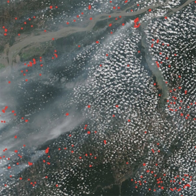
For fire detection, VIIRS and MODIS complement each other well. Both the VIIRS 375 m data and the MODIS fire product show good agreement in hotspot detection. However, VIIRS provides an improved response for smaller fires and provides improved mapping of large fire perimeters. In addition, the VIIRS 375 m data show a better response in nighttime observations, when fire activity normally subsides. These benefits make VIIRS fire data well-suited for use in near real-time alert systems, such as the LANCE Fire Information for Resource Management System (FIRMS). As a result, FIRMS now includes hotspot detections from both MODIS and VIIRS 375 m products. (While a VIIRS M-Band 750 m active fire data product also is available, FIRMS has opted to distribute the 375 m product rather than the 750 m product due to the increased spatial resolution and increased number of fires detected by the 375 m product.)
, 750 m VIIRS (center) and 375 m VIIRS (right) data at the Taim Ecological Reserve in southern Brazil. The data cover the period 26 - 31 March 2013. The white outline shows represents the burned area mapped using 30 m Landsat-7 on 31 March. This figure is reproduced here courtesy of Wilfrid Schroeder, University of Maryland.")
Starting later this year, VIIRS standard products produced by the Suomi NPP Land Science Investigator-led Processing System (Land SIPS) will be available from the Land Processes Distributed Active Archive Center (LP DAAC) and National Snow and Ice Data Center DAAC (NSIDC DAAC). Standard products are designed for use in scientific research and require at least 24 to 48 hours to process.
While only the VIIRS near real-time fire and reflectance products currently are available through LANCE, additional VIIRS near real-time products are expected to be added. For more information, please visit the following websites: