Atmospheric Science Data Center (ASDC)
Now Available: New Global Energy and Water Exchanges Program Data Product
NASA's ASDC released an updated version of the Global Energy and Water Exchanges (GEWEX) Program Surface Radiation Budget (SRB) Integrated (Release-4) Longwave Monthly Average by Local Land-only Fluxes data product. The fluxes include all-sky, clear-sky, and pristine-sky top-of-atmosphere upward fluxes (outgoing longwave radiation), all-sky, clear-sky, and pristine-sky upward and downward fluxes at the tropopause, 200hPa, 500hPa, and surface. The temporal range is July 1983 through December 1987, and the data are temporally averaged on local solar time.
Access the GEWEX SRB data product and more information

New CERES Terra and Aqua Data Products Available
A new Clouds and the Earth's Radiant Energy System (CERES) Cloud and Radiative Swath One Degree (CRS1deg) Hour Terra-MODIS Edition 4A data product is available. This product provides instantaneous footprint data hourly on a 1-degree latitude and longitude global grid from the Terra CERES Flight Model 1 (FM1) or FM2 CER_CRS_Terra-FM1-Moderate Resolution Imaging Spectroradiometer (MODIS) Edition4A instantaneous footprints. The data provide instantaneous averages of computed top of atmosphere (0.01-hPa), within the atmosphere (850-, 500-, 200-, and 70-hPa), and surface fluxes. The data have been processed from January 1, 2018, to December 31, 2022, and are available in daily netCDF4 files.
ASDC also has released a related product that provides hourly data on a 1-degree latitude and longitude global grid from the Aqua CERES Flight Model 3 (FM3) or FM4 CER_CRS_Aqua-FM3-MODIS_Edition4A instantaneous footprint data.
Access the new CERES data products and more information
TRACE-A DC-8 In-Situ Trace Gas Datasets Released
ASDC released several datasets from the Transport and Atmospheric Chemistry near the Equator–Atlantic (TRACE-A) suborbital campaign, which was conducted in the Atlantic from September 21 to October 24, 1992. The aim of the TRACE-A campaign was to determine the cause and source of high concentrations of ozone that accumulate over the Atlantic Ocean between southern Africa and South America from August to October. The campaign used a DC-8 aircraft equipped with 19 instruments to collect data. Included among those instruments were the Differential Absorption Lidar (DIAL), the Laser-Induced Fluorescence, the O3-NO Ethylene/Forward Scattering Spectrometer, the Modified Licor, and the DACOM IR Laser Spectrometer. The campaign also used ozonesondes that were dropped from the aircraft to gather data on ozone, temperature, and atmospheric pressure.
More information about the TRACE-A dataset
- DIAL instrument Data
- Trajectory Data
- Supplementary Satellite Data
- Sondes Data
- Brazil Data
- Meteorology and Navigation Data
- Merge Data
Goddard Earth Sciences Data and Information Services Center (GES DISC)
AIRS Joint Single Footprint Retrieval Algorithm Data Product Released
NASA's GES DISC and the Atmospheric Infrared Sounder (AIRS) Project released the Joint Single Footprint Retrieval Algorithm (JoSFRA) Level-2 data product derived from infrared spectra obtained by the AIRS instrument aboard NASA's Aqua satellite.
The product includes atmospheric temperature and water vapor profiles, surface temperature, cloud-top temperature/pressure, effective cloud optical depth, and effective cloud particle radius, and associated metadata. Further, the product is divided into a series of 6-minute time segments, or granules, with each granule making up one file. For the initial release of Version 2, a limited test dataset is provided.
Access JoSFRA data and more information

TROPESS Chemical Reanalysis Products Now Available
Tropospheric Ozone and Precursors from Earth System Sounding (TROPESS) Chemistry Reanalysis Version 2 (TCR-2) datasets for trace gasses of ozone (O3), carbon monoxide (CO), hydroxide (OH), sulfur dioxide (SO2), peroxyacetyl nitrate (PAN), nitric acid (HNO3), nitric oxide (NO), nitrogen dioxide (NO2), formaldehyde (CH2O), aerosols (SO4, NH4, and NO3), and emission sources of nitrogen oxide (NOx), CO, and SO2. TCR-2 features a chemical reanalysis technique that combines observational information and provides comprehensive information on tropospheric composition variations using data assimilation from multiple satellite instruments. These instruments include the Ozone Monitoring Instrument (OMI), the Global Ozone Monitoring Experiment-2 (GOME-2), the Scanning Imaging Absorption Spectrometer for Atmospheric Cartography (SCIAMACHY), the Microwave Limb Sounder (MLS), the Tropospheric Emission Spectrometer (TES), and the Measurements Of Pollution In The Troposphere (MOPITT).
Access TROPESS TCR-2 datasets and more information
Level 3 Single Field-of-View Sounder Atmospheric Products Data Product Released
GES DISC and the NASA Sounder Science Investigator-led Processing Systems (SIPS) at NASA's Jet Propulsion Laboratory (JPL) released the Level 3 Single Field-of-View Sounder Atmospheric Products (SiFSAP). These products are derived from the Cross-track Infrared Sounder (CrIS) and Advanced Technology Microwave Sounder (ATMS) instruments aboard the Suomi National Polar-orbiting Partnership (Suomi NPP) satellite and contain a variety of geophysical parameters, including atmospheric temperature profiles, water vapor, ozone profiles, clouds, and surface properties.
Access the new Suomi NPP data products and more information
OCO-2 Version 11.2 Forward Processing Datasets Released
GES DISC and the Orbiting Carbon Observatory-2 (OCO-2) Project released Version 11.2 forward processing datasets. Version 11.2, which was put in place for all data produced on and after April 2, 2024, includes two significant changes: 1) a transition in the meteorological data products used as inputs to the Level 2 retrievals, and 2) a continuation of the transition to a new digital elevation model first introduced in the version 11.1 Lite data products.
The primary change involves the meteorological data inputs that are used for the OCO-2 Level 2 retrievals. The OCO-2 science team made the decision to switch from using the GEOS FP-IT product to the GEOS-IT products in the forward processing and retrospective processing on April 1, 2024, and to switch to the new data label of V11.2. All OCO-2 products prior to April 1, 2024, will remain as V11.1 products that use the GEOS FP-IT meteorological data as input for the retrievals.
Access OCO-2 V11.2 products and more information
NASA Western North America Land Data Assimilation Version D1.0 Product Now Available
GES DISC and the NASA Goddard Space Flight Center's Hydrological Sciences Laboratory (HSL) released the Western North America Land Data Assimilation (WLDAS) Version D1.0 data product.
The WLDAS uses NASA's Land Information System (LIS) to configure and drive the Noah Multiparameterization (Noah-MP) Land Surface Model to simulate land surface states and fluxes. WLDAS incorporates meteorological observables including precipitation, incoming shortwave and longwave radiation, near surface air temperature, humidity, wind speed, and surface pressure, along with parameters such as vegetation class, soil texture, and elevation as inputs to simulate land surface energy and water budget processes. Outputs of the model include 1-kilometer spatial resolution daily soil moisture, snow depth and snow water equivalent, evapotranspiration, and soil temperature, as well as derived quantities such as groundwater recharge and anomalies of the state variables from 1979 to 2023. WLDAS data are archived in netCDF format.
Access WLDAS Version D1.0 data and more information

Global Hydrometeorology Resource Center Distributed Active Archive Center (GHRC DAAC)
Turbulent Air Motion Measurement System (TAMMS) IMPACTS Dataset Now Available
NASA's GHRC DAAC released the Turbulent Air Motion Measurement System (TAMMS) Investigation of Microphysics and Precipitation for Atlantic Coast-Threatening Snowstorms (IMPACTS) dataset, which consists of wind speed, wind direction, and cross wind speed measurements from the TAMMS instrument onboard the NASA P-3 aircraft used during the IMPACTS field campaign. Data are available from January 18, 2020, through February 28, 2023, and are in ASCII format.
Access TAMMS IMPACTS data and more information
Land Processes DAAC (LP DAAC)
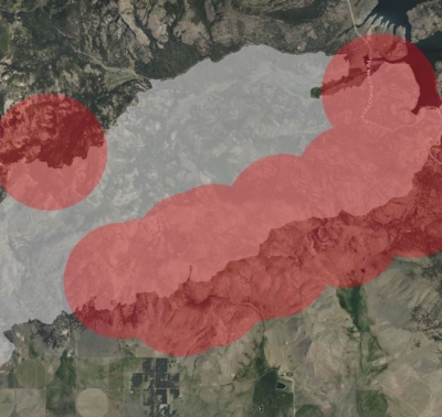
OPERA Land Surface Disturbance Annual Version 1 Data Product Released
NASA's LP DAAC released the Observational Products for End-Users from Remote Sensing Analysis (OPERA) Land Surface Disturbance Annual from Harmonized Landsat and Sentinel-2 (HLS) Version 1 data product. The product summarizes vegetation and generic disturbances collected from the Operational Land Imager (OLI) aboard the Landsat 8 and Landsat 9 satellites and the Multi-Spectral Instrument (MSI) aboard the Sentinel-2A/B satellites for the OPERA Disturbance Alert data product.
The Disturbance Annual product tracks changes at a yearly scale, aggregating changes identified in the OPERA Disturbance Alert product. Only confirmed disturbances from the associated year are reported together with the date of initial disturbance. Data are distributed at 30-meter spatial resolution.
Access OPERA Land Surface Disturbance Annual data and more information

New EMIT Resources Available
LP DAAC released two Python Jupyter notebooks demonstrating how to work with the Earth Surface Mineral Dust Source Investigation (EMIT) Level 2B Methane Enhancement Data 60-meter and Level 2B Estimated Methane Plume Complexes 60-meter data products. The notebooks can be found in LP DAAC's EMIT Data Resources Repository.
More information about the EMIT Jupyter notebooks
VIIRS Version 2 Vegetation Indices and ECOSTRESS Tiled Calibrated Radiance Data Products Now Available in AppEEARS
The Visible Infrared Imaging Radiometer Suite (VIIRS) Version 2 Vegetation Indices product suite from the Suomi NPP and NOAA-20 satellites is now available in Version 3.53 of the Application for Extracting and Exploring Analysis Ready Samples (AppEEARS) data tool. In addition, the ECOSTRESS Tiled Top of Atmosphere Calibrated Radiance Instantaneous Level 1C Global 70 meter (ECO_L1CT_RAD) Version 2 data product is now available in AppEEARS version 3.51.
More information about the VIIRS Product Suite
More information about the ECOSTRESS product
LP DAAC Products to be Removed from USGS EarthExplorer
LP DAAC data products will be removed from USGS's EarthExplorer on August 30, 2024, and will no longer be distributed from EarthExplorer. A list of products that will be affected can be found on the LP DAAC website. Users are encouraged to familiarize themselves with NASA's Earthdata Search for downloading these products.
More information about the removal of LP DAAC-distributed data from EarthExplorer
Forward Processing for VIIRS Version 1 Ends June 30, 2024
Suomi NPP VIIRS Version 1 (Collection 1) land data products will cease forward processing on June 30, 2024. VIIRS Version 1 data products will remain available for distribution, but users are encouraged to transition to VIIRS Version 2. The VIIRS Earth Science Data Records for Version 2 offers new data products from both the Suomi NPP and the NOAA-20 satellites to provide continuity with MODIS land science products. Suomi NPP VIIRS Version 1 data products will remain accessible for download as additional Version 2 data products are released.
More information about the Suomi NPP VIIRS Version 1 land data product processing
Level 1 and Atmosphere Archive and Distribution System DAAC (LAADS DAAC)
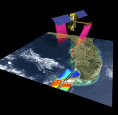
New Geostationary Earth Orbit–Low-Earth Orbit Dark Target Aerosol Data Products Suite Now Available
NASA's LAADS DAAC released a GEO-LEO Dark Target Aerosol data products suite. The Geostationary Earth Orbit (GEO), Low-Earth Orbit (LEO) Dark Target Aerosol suite of global aerosol products is produced from data acquired by both geostationary and low-Earth orbit satellites between January 2019 and December 2022 that shows aerosol movement across the globe every 10 minutes.
The GEO-LEO Dark Target Aerosol project uses a special version of the MODIS Dark Target (DT) aerosol retrieval algorithm to produce Aerosol Optical Depth (AOD) and other aerosol parameters derived independently from four geostationary and four low Earth orbit sensors aboard eight different satellites. The addition of the low Earth orbit sensors strengthens a major goal of this project, which is to render a consistent science maturity level across dark target aerosol products derived from both types and sources of orbital satellites.
More information about the new Dark Target Aerosol products
National Snow and Ice Data Center DAAC (NSIDC DAAC)
Near Real-Time MODIS/Terra Dataset Released
NASA's NSIDC DAAC released the Near Real-Time MODIS/Terra Level 3 Global Daily 500-meter SIN Grid Snow Cover, Grain Size, and Dust Radiative Forcing, Version 1 dataset. This dataset represents an updated version of the MODIS Snow Covered Area and Grain-size (MODSCAG) and MODIS Dust Radiative Forcing in Snow (MODDRF) datasets previously produced by NASA's JPL. Dataset parameters include snow fraction, snow grain size, vegetation fraction, rock fraction, ice fraction, shade fraction, deltavis, radiative forcing, and optical snow grain size over areas of the western United States. The dataset's temporal range is October 19, 2023, to present. Daily processing will begin in the next few months; until daily processing begins, files will be updated monthly.
Access the new near real-time MODIS/Terra snow cover dataset
Updated MEaSUREs Greenland Image Mosaics and 6- and 12-day Ice Sheet Velocity Mosaics Dataset

The Making Earth System Data Records for Use in Research Environments (MEaSUREs) Greenland Image Mosaics from Sentinel-1A and -1B, Version 4 and Greenland 6- and 12-day Ice Sheet Velocity Mosaics from synthetic aperture radar (SAR), Version 2 datasets available through NASA's NSIDC DAAC have been updated. The temporal coverage for the image mosaics has been extended until January 31, 2024, and the 6- and 12-day velocity mosaics now spans until January 19, 2024.
Accesss Greenland Image Mosaics data
New ICESat-2 Dataset Available
The Ice, Cloud, and land Elevation Satellite-2 (ICESat-2) Derived Sea Ice Melt Pond Characteristics from the Density-Dimension Algorithm, Version 3 dataset is now available. This dataset provides locations and depths of melt ponds in the Multi-Year Arctic Sea Ice Region (MYASIR) calculated from the Advanced Topographic Laser Altimeter System (ATLAS)/ICESat-2 Level 2A Global Geolocated Photon Data, Version 5 dataset using an auto-adaptive algorithm. The dataset's temporal range is June 4 to August 28, 2020.
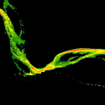
High Mountain Asia Flood Dataset Released
The High Mountain Asia 30-meter and 8-meter Flood Geomorphic Potential, Version 1 dataset is now available. This dataset contains Flood Geomorphic Potential (FGP) at 30-meter (m) resolution for the High Mountain Asia region and 8-m resolution over Nepal. FGP is a digital elevation model (DEM)-derived index that provides high-resolution flood mapping based on bankfull elevations, defined in terms of river widths, and elevation differences between points under examination and the closest bankfull elevations in the river network. The temporal coverage corresponds to the publication dates of the DEMs used to produce the corresponding FGP indices. For the 30-m files, this date is April 22, 2021; for the 8-m files, it is July 16, 2017.
Access High Mountain Asia FGP data
New SnowEx23 Dataset Available
The SnowEx23 University of Wyoming Ground Penetrating Radar, Version 1 dataset is available from NASA's NSIDC DAAC. This dataset contains the results of ground-penetrating radar surveys conducted at the Arctic Coastal Plain site and the Upper Kuparuk/Toolik site in northern Alaska during the SnowEx23 field campaign. Data include two-way travel time, derived snow depth, and derived snow water equivalent. Temporal range is March 8, 2023, to March 14, 2023.
Access the SnowEx23 Ground Penetrating Radar, Version 1, data
SnowEx20-21 Cameron Pass Dataset Released
The SnowEx20-21 Cameron Pass Derived Snowpack Relative Permittivities and Densities from Ground Penetrating Radar, Version 1 dataset is now available. This dataset contains the results of ground-penetrating radar surveys conducted at Cameron Pass, Colorado, during the SnowEx20 campaign. Data include two-way travel time, lidar-measured snow depth, derived snow water equivalent, derived snow density, and derived relative permittivity. Temporal range is December 18, 2019, to May 27, 2021.
Access the SnowEx20-21 Cameron Pass Dataset
New MODIS/Terra Snow Cover Climatology Dataset
A new MODIS/Terra Global Annual 0.01 Deg Climate Modelling Grid Snow Cover Climatology, Version 1 dataset at NASA's NSIDC DAAC presents new global snow cover classification regimes derived from the MODIS/Terra cloud gap-filled Normalized Difference Snow Index data, elevation, and temperature climatology inputs. Temporal range is March 1, 2000, to July 31, 2023.
Access the new MODIS/Terra Snow Cover Climatology dataset
New IceBridge Airborne Topographic Mapper (ATM) Dataset
The IceBridge Airborne Topographic Mapper (ATM) Waveform Derived Snow Effective Grain Radius, Version 1 dataset is now available. This dataset contains surface grain size estimates of snow and ice derived from waveform measurements from ATM narrow-swath and wide-swath instrumentation. The spatial extent spans the Arctic with the majority of data occurring on the Greenland ice sheet. Temporal coverage spans from July 17, 2017, to September 11, 2019.
Access the IceBridge ATM dataset and more information
ATLAS/ICESat-2 ATL14 and ATL15 Datasets Retired
The ATLAS/ICESat-2 Level 3B Gridded Antarctic and Arctic Land Ice Height (ATL14), Version 2 and ATLAS/ICESat-2 Level 3B Gridded Antarctic and Arctic Land Ice Height Change (ATL15), Version 2 datasets have been retired as of April 29, 2024. Access to the data is no longer available. Dataset documentation will remain accessible for future reference. Users should transition to Version 3 of these datasets.
More information about the ATL14 and ATL15 dataset retirement
Physical Oceanography DAAC (PO.DAAC)
GHRSST Level 2P NOAA-20/NOAA-21 VIIRS Version 3.0 Sea Surface Temperature datasets from NAVO Now Available
NASA's PO.DAAC released the Naval Oceanographic Office (NAVO) VIIRS Level 2P v3.0 Sea Surface Temperature (SST) datasets from the VIIRS instruments aboard the Joint Polar Satellite System (JPSS) NOAA-20 and NOAA-21 satellites. The Level 2P datasets are reported in the instrument native swath projection with 750-meter (along) x 750-meter (across) spatial resolution, and provide global near daily-coverage of SST at 1-meter depth.
These new datasets complement the existing NAVO Suomi NPP VIIRS Level 2P dataset, and are produced with NAVO's Level-2 SST processor version 3.0. The datasets are formatted in netCDF4 and are compliant with the Group for High Resolution Sea Surface Temperature (GHRSST) Data Processing Specification v2.0. Detailed information regarding the GHRSST L2P products is available from PO.DAAC's GHRSST mission webpage.
Access the new NAVO SST datasets and more information
Updated SWOT Jupyter Notebook Tutorials and Resources in the PO.DAAC Cookbook
The Jupyter notebook tutorials and resources for the Surface Water and Ocean Topography (SWOT) mission in the PO.DAAC Cookbook have been updated. The cookbook now includes the recent SWOT data release on March 6, 2024, and offers ample tutorials to help users explore SWOT hydrology and oceanography datasets in the cloud or on their local machines.
Select Jupyter notebooks in the cookbook's SWOT Chapter include:
- Access SWOT Hydrology data in the cloud | SWOT Hydrology data locally
- Access SWOT Oceanography data in the cloud | Oceanography data locally
- SWOT Raster Multifile Access & Quality Flag Application in the cloud | Raster Multifile Access & Quality Flag Application locally
- SWOT River Shapefile Exploration locally
- Transform SWOT Datetime field for use in GIS Software locally
- Data Story: Retrieving river attributes and plotting a longitudinal profile in the cloud
- SWOT Quality Flag Application (Tutorial)