Even on a good day, the Egyptian capital and its neighboring Nile Delta cities suffer from some of the worst air pollution on Earth. Two million cars prowl the traffic-clogged streets, while a thousand factories belch smoke into the air. On top of the everyday pollution, farmers outside the city burn leftover rice husks at the end of the growing season, adding smoke to already smoggy air.
On a bad day, the smog in the city is unbearable. And those bad days now happen like clockwork, appearing every fall since 1999 and lasting days at a time. As the summer heat fades, a so-called “black cloud” settles over the city, smothering the Nile Delta in a black-brown haze that burns people’s eyes and throats.

How can Egyptians get rid of the black cloud? The first problem was, as Heba Marey, a scientist at Alexandria University in Egypt, said, “Researchers didn’t have a firm cause for the black cloud formation.” In 2009, as a doctoral student studying remote sensing, Marey realized that satellite data might lead to a clear answer that would be key to reducing the pollution at its source.
Worst pollution on the planet
In 2007 the World Bank ranked Cairo’s air worst in the world for pollution by particulates, the tiny fragments of soot or dust that are most damaging to human lungs. High emissions contribute to the problem, but Cairo’s topography and climate make the pollution even worse. The city lies in a valley surrounded by hills, which hold the poisoned air like water in a bowl. In the fall, frequent temperature inversions settle over Cairo—a weather phenomenon that occurs when a warmer, lighter air mass moves over a colder, denser air mass, trapping a layer of air close to the ground. The inversions still the winds, creating a stagnant soup of unmoving air. Meanwhile, an extremely dry climate means that cleansing rainstorms rarely appear.
But the black cloud is different from the pollution that plagues the city every day. It appears only once a year, in September or October. And it is much more intense than the regular pollution, darkening the sky into a foreboding smog. The black cloud brings pollution levels up to ten times the limits set by the World Health Organization, and can persist for days or weeks at a time. It sends people to the hospital with exacerbated lung infections and asthma attacks at unusually high rates, and contributes to cancer and other long-term health problems.
Before Marey started her research, the source of the pollution cloud was a mystery. People in the city blamed farmers’ fires, while many farmers, who live a hundred miles outside Cairo, argued that their smoke could not feasibly travel all the way to Cairo, and that the cause must instead be the cars and factories in the city itself. In 2004, authorities banned rice husk burning and introduced other pollution-reducing measures, but the annual cloud continued.
Marey wanted to look at the problem from a different perspective. Even though people had guesses about the reasons for the black clouds, the ground data available in Egypt only gave people the same information that they could already see with their own eyes: air pollution got much worse during the black cloud events.
Marey had received a research fellowship to study abroad as part of her PhD work, and decided to use it to learn more about the black cloud. She contacted John Gille at the National Center for Atmospheric Research (NCAR) in Colorado and proposed that they work together. “NCAR is the best place in the world for atmospheric remote sensing science,” Marey said. “It was a wonderful opportunity to work there.”
When she arrived in Colorado, Gille helped Marey learn more about remote sensing and explore the available data. Then she moved on to put the pieces together for her study. Gille said, “She was very enterprising. She talked to a lot of people, asked a lot of questions, and found the data sets she needed to answer her questions.”

New view of pollution
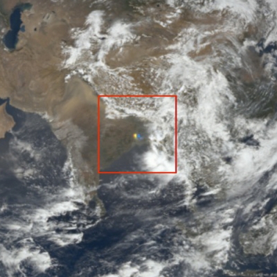
Marey started by looking at the agricultural fires that burned outside Cairo each fall, using NASA Moderate Resolution Imaging Spectroradiometer (MODIS) fire count maps, which showed the locations and intensity of fires. The data showed that fires were closely linked in time with the pollution, preceding the black cloud’s arrival by just six to nine hours.
The timing of the fires was a strong clue, but it did not prove that the smoke from the fires reached Cairo. To trace the path of the smoke plumes, Marey used Multi-Angle Imaging Spectroradiometer (MISR) data from NASA's Atmospheric Science Data Center (ASDC). Using a tool called the MISR Interactive Explorer (MINX), and trajectory analysis models, she combined the plume data with the fire data and atmospheric models to learn where the smoke plumes originated, and where they traveled. As it turned out, the plumes blew directly towards Cairo.
Those two findings showed that smoke plumes were contributing to the black cloud. But it did not explain why the pollution was so persistent. Using temperature, meteorological data, and models that described the movement of smoke and pollution, Marey found an explanation. After rice husk burning was made illegal, farmers started burning it at night and early in the morning, when they are less likely to get caught. The fires now burn at the worst possible time for Cairo’s air. “The pollution reaches Cairo after sunset, which is just when the temperature inversion starts to form,” she said. Marey also found that the black cloud lurks low to the ground, concentrated in the bottom 500 meters (1,600 feet) of the atmosphere. Since the pollution hangs low as it travels, it slides into the city close to the ground, where it can be trapped by the temperature inversion.
All the clues pointed to agricultural fires as the source of the black cloud. But if that was true, why did the black cloud not appear before 1999? Marey only had satellite data back to 2000, so she could not use it to look at the differences between the decades. Instead, she turned to agricultural statistics, which showed a sharp growth in rice production between 1990 and 2000. Rice production increased from about three million tons in 1990 to nearly six million tons in 2000. As rice production grew, farmers had more tons of rice husks to burn. At the same time, farmers were upgrading their homes to cook with gas stoves rather than burning rice husks for fuel, which meant they had more leftover plant material to get rid of all at once.
Clearing the air
Marey’s results were surprising in their clarity. “She put together data from sources in a new way, to get an unequivocal answer,” Gille said. “Where there are fires, there is a black cloud.”
How to clean up the black cloud is a far murkier question. One idea is to use the waste as biofuel. Other efforts have focused on composting the waste. But the government will need to find a way to provide incentives for farmers to dispose of the waste in a different way, which might take them more time. Marey said, “The cheapest and easiest way for them to get rid of it is just to burn it in the open.”

With the 2010 revolution in Egypt, it is unclear who will step in to replace the old government, and societal questions such as how to deal with air pollution are up in the air. Marey believes it is a mistake to focus all the attention on biomass burning when the Nile Delta cities are already so polluted. Instead, she says, the country needs to reduce emissions overall, from cars and industry as well as agriculture, and to better plan for the continued growth of cities like Cairo.
“Cairo’s air has become overloaded,” Marey said. “It’s like when you have a cup of water, and you add sugar and more sugar—eventually the water can’t absorb any more sugar.”
References
Marey, H. S., J. C. Gille, H. M. El-Askary, E. A. Shalaby, and M. E. El-Raey. 2010. Study of the formation of the “black cloud” and its dynamics over Cairo, Egypt, using MODIS and MISR sensors. Journal of Geophysical Research 115, D21206, doi:10.1029/2010JD014384.
Safar, Z. and M. W. Labib. 2010. Assessment of particulate matter and lead levels in the Greater Cairo area for the period 1998-2007. Journal of Advanced Research 1: 53-63, doi:10.1016/j.jare.2010.02.004.
For more information
NASA Goddard Earth Sciences Data and Information Services Center (GES DISC)
NASA Atmospheric Science Data Center (ASDC)
Multi-Angle Imaging Spectroradiometer (MISR)
Moderate Resolution Imaging Spectroradiometer (MODIS)
National Center for Atmospheric Research
| About the remote sensing data used | ||
| Satellite | Terra | Terra |
| Sensor | Multi-Angle Imaging Spectroradiometer (MISR) | Moderate Resolution Imaging Spectroradiometer (MODIS) |
| Data sets | Terrain Radiance, Terrain Height, and Aerosol | Fire Count |
| Resolution | 275 meters or less | 1 kilometer |
| Parameter | Aerosols | MODIS thermal anomaly product |
| DAACs | NASA Atmospheric Science Data Center (ASDC) | NASA Goddard Earth Sciences Data and Information Services Center (GES DISC) |
| Data were acquired through the MISR Interactive Data Explorer (MINX) at ASDC. | ||
Photograph in title graphic shows a camel rider looking back at the smog blanketing Cairo, Egypt. The geography and climate of Cairo conspire to worsen air pollution. The city lies in a valley between two mountain ranges, which slows wind flow and traps dirty air. Frequent temperature inversions stifle airflow further, and infrequent rainfalls mean dirty air rarely gets washed away by a cleansing storm. (Courtesy D. Evers)